Difference between revisions of "Category:Online Data"
m |
|||
| (One intermediate revision by the same user not shown) | |||
| Line 1: | Line 1: | ||
These pages give an introduction to the origin of the datasets available through the EMD / WindPRO internet server services. These services are implemented in order to aid the access to global or regional datasets of: | These pages give an introduction to the origin of the datasets available through the EMD / WindPRO internet server services. These services are implemented in order to aid the access to global or regional datasets of: | ||
| + | *[[:Category:Bathymetry Models|Bathymetry models (water depths)]] | ||
| + | *[[:Category:Existing Turbines|Databases on existing wind turbines]] | ||
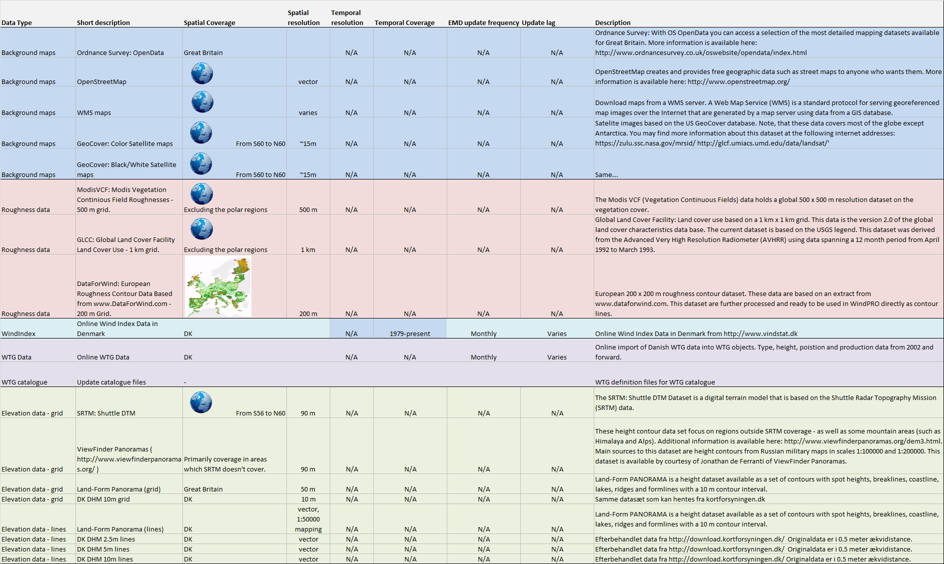
*[[:Category:Digital Elevation Models|Height contours]] | *[[:Category:Digital Elevation Models|Height contours]] | ||
*[[:Category:Digital Roughness Data|Roughness data]] | *[[:Category:Digital Roughness Data|Roughness data]] | ||
| + | *[[:Category:Forest Maps|Forest maps (tree heights)]] | ||
*[[:Category:Maps|Map data]] | *[[:Category:Maps|Map data]] | ||
| + | *[[:Category:Solar Data|Solar radiation data]] | ||
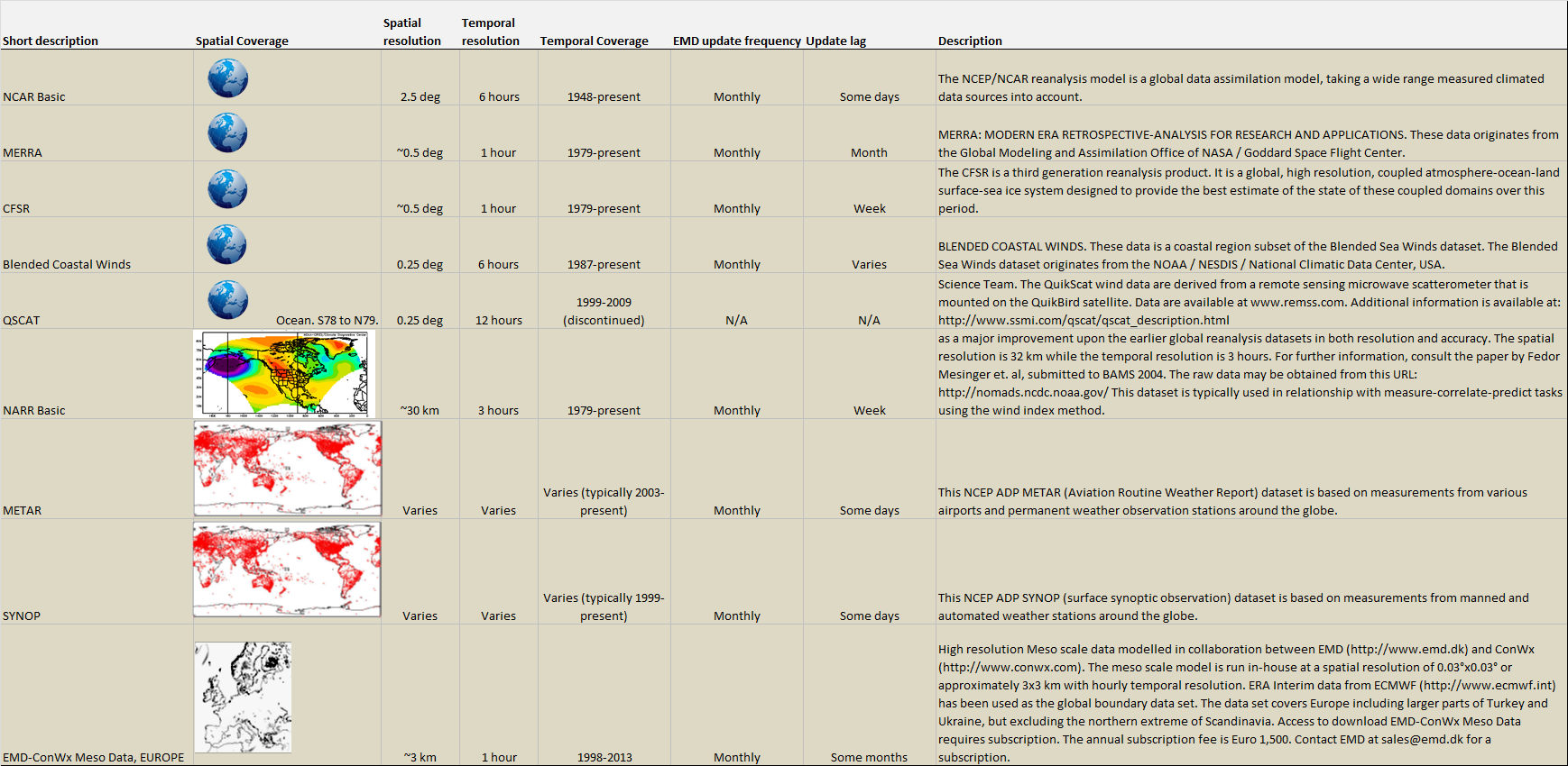
*[[:Category:Wind Data|Wind data]] | *[[:Category:Wind Data|Wind data]] | ||
| − | + | ||
| − | |||
Most of these datasets are available directly from the individual objects in WindPRO holding the dataset of interest, e.g. roughness data are loaded from the ‘Online Data’ button in the area object of WindPRO. Note, that even if the datasets delivered may be convenient to use in many wind turbine projects, then a critical review of the data is always needed, as these are typically delivered from remote sensing devices, where the accuracy is not as high as typically required within such applications. Due to the global or large regional coverage of these datasets, another issue is that erroneous data are bound to exist, even if automated quality checks have been performed – as well as site-specific evaluations of the data by the WindPRO team. Thus, when working on a specific site, it is crucial that you do a quality evaluation of the online-datasets that you choose to use. | Most of these datasets are available directly from the individual objects in WindPRO holding the dataset of interest, e.g. roughness data are loaded from the ‘Online Data’ button in the area object of WindPRO. Note, that even if the datasets delivered may be convenient to use in many wind turbine projects, then a critical review of the data is always needed, as these are typically delivered from remote sensing devices, where the accuracy is not as high as typically required within such applications. Due to the global or large regional coverage of these datasets, another issue is that erroneous data are bound to exist, even if automated quality checks have been performed – as well as site-specific evaluations of the data by the WindPRO team. Thus, when working on a specific site, it is crucial that you do a quality evaluation of the online-datasets that you choose to use. | ||
Revision as of 23:06, 16 March 2020
These pages give an introduction to the origin of the datasets available through the EMD / WindPRO internet server services. These services are implemented in order to aid the access to global or regional datasets of:
- Bathymetry models (water depths)
- Databases on existing wind turbines
- Height contours
- Roughness data
- Forest maps (tree heights)
- Map data
- Solar radiation data
- Wind data
Most of these datasets are available directly from the individual objects in WindPRO holding the dataset of interest, e.g. roughness data are loaded from the ‘Online Data’ button in the area object of WindPRO. Note, that even if the datasets delivered may be convenient to use in many wind turbine projects, then a critical review of the data is always needed, as these are typically delivered from remote sensing devices, where the accuracy is not as high as typically required within such applications. Due to the global or large regional coverage of these datasets, another issue is that erroneous data are bound to exist, even if automated quality checks have been performed – as well as site-specific evaluations of the data by the WindPRO team. Thus, when working on a specific site, it is crucial that you do a quality evaluation of the online-datasets that you choose to use.
These pages give a brief introduction to all of the datasets, as well as references to their origin. Before using the datasets, please consult the individual dataset descriptions and internet resources to clarify the details and limitations for these data and any restrictions in their application in the commercial field.

Subcategories
This category has the following 8 subcategories, out of 8 total.
Pages in category "Online Data"
The following 139 pages are in this category, out of 139 total.
B
C
D
E
- EMD-ConWx Meso Data Europe
- EMD-Global Wind Data (based on ERA-Interim)
- EMD-WRF Benchmarks
- EMD-WRF Europe+ (ERA5)
- EMD-WRF India
- EMD-WRF Indonesia
- EMD-WRF Middle East
- EMD-WRF On-Demand and Custom-Area
- EMD-WRF On-Demand ICING
- EMD-WRF South Africa
- EMD-WRF South Korea (ERA-Interim)
- EMD-WRF South Korea - ERA5
- ERA5 Gaussian Grid
- ERA5(T) Rectangular Grid
- Estonian Canopy Heights
- Estonian Elevation Models
- Estonian Topographic Map
- EU-DEM
- European EMODnet Bathymetry
F
- Faroe Islands Elevation Models
- Faroe Islands Orthophotos
- Faroe Islands Topographic Map
- Finnish Elevation Model
- Finnish LUKE Forest Map
- Finnish Orthophoto Mosaic
- Finnish Topographic Map
- Finnish Wind Turbines
- FR Wind Turbines Georisques
- French Elevation Models
- French Orthophoto Mosaic
- French Raster Map
G
- GASP Global
- GeoCover Images
- German Bavaria Elevation Models
- German Berlin Elevation Model
- German Brandenburg Elevation Model
- German DGM datasets
- German Hamburg Elevation Model
- German Hessen Elevation Models
- German NRW Elevation Model
- German Saxony Elevation Models
- German Saxony-Anhalt Elevation Models
- German Thuringia Elevation Models
- German Topographic Maps and Ortophotos
- Glob Cover
- Global AW3D30
- Global Bathymetry GEBCO
- Global Land Cover Characteristics
- Global Sentinel-2 10m Canopy Height ETH
- Google Earth Export
I
L
N
- NASA-DEM
- National Elevation Dataset
- National Land Cover Database 2011
- NCEP / NCAR Global Reanalysis Data
- NCEP North American Regional Reanalysis Data
- Near-Global Forest Canopy Heights GLAD
- Netherlands Elevation Models
- New European Wind Atlas (NEWA)
- NORA3
- Norwegian Elevation Models
- Norwegian SR16 Forest Heights
- Norwegian Topographic Map