Difference between revisions of "Main Page"
| Line 40: | Line 40: | ||
* [[UK-Wales_Elevation_Model|UK - Wales Elevation Model]] | * [[UK-Wales_Elevation_Model|UK - Wales Elevation Model]] | ||
* [[National_Elevation_Dataset|US National Elevation Dataset (NED)]] | * [[National_Elevation_Dataset|US National Elevation Dataset (NED)]] | ||
| − | |||
<br> | <br> | ||
'''[[:Category:Digital_Roughness_Data|Digital Roughness Models (DRM)]]'''<br><hr> | '''[[:Category:Digital_Roughness_Data|Digital Roughness Models (DRM)]]'''<br><hr> | ||
| Line 75: | Line 74: | ||
<br> | <br> | ||
'''[[:Category:Existing_Turbines|Databases on Turbines]]'''<br><hr> | '''[[:Category:Existing_Turbines|Databases on Turbines]]'''<br><hr> | ||
| − | |||
* [[Danish_Wind_Turbines|Danish Turbines (makes, positions, productions)]] | * [[Danish_Wind_Turbines|Danish Turbines (makes, positions, productions)]] | ||
| + | * [[Finnish_Wind_Turbines|Finnish Turbines (positions)]] | ||
* [[OSM_Turbines|Open Streep Map Turbines (positions only)]] | * [[OSM_Turbines|Open Streep Map Turbines (positions only)]] | ||
* [[US_Wind_Turbines|Turbines in the United States]] | * [[US_Wind_Turbines|Turbines in the United States]] | ||
| − | * [[ | + | * [[WTG_Catalogue|WindPRO Wind Turbine Catalogue]] |
|'''[[:Category:Maps|Digital Map Data - Orthophotos]]'''<br><hr> | |'''[[:Category:Maps|Digital Map Data - Orthophotos]]'''<br><hr> | ||
* [[Danish_Orthophoto_Mosaic|Danish Orthophoto Mosaic]] | * [[Danish_Orthophoto_Mosaic|Danish Orthophoto Mosaic]] | ||
Revision as of 16:34, 13 November 2019

This WindPRO-Wiki currently contains a description of all the online-datasets that are available directly from within WindPRO. This wiki seeks to describe the remote sensing data and other data available for download or which can be accessed from WindPRO. Since more online-datasets become available in-between WindPRO releases, then EMD has decided to release the online dataset documentation in a dynamic wiki-format. This enables a more dynamic (and frequent) update of the associated datasets and their documentation.
Please note: This page describes the datasets available within WindPRO 3.3.
WindPRO Documentation on Online Data
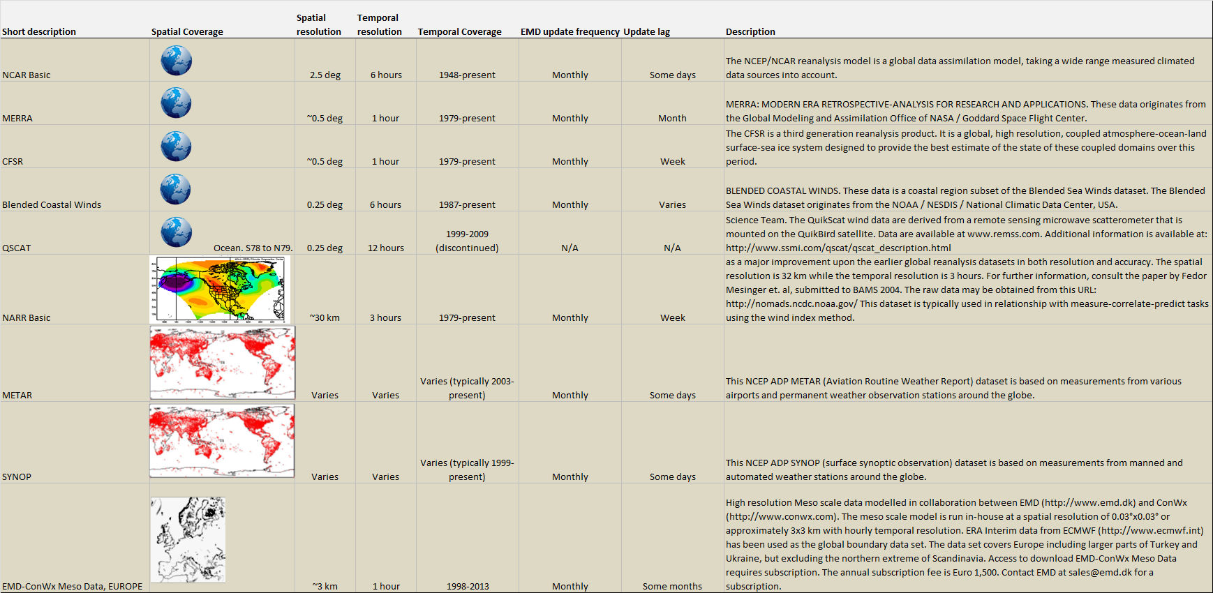
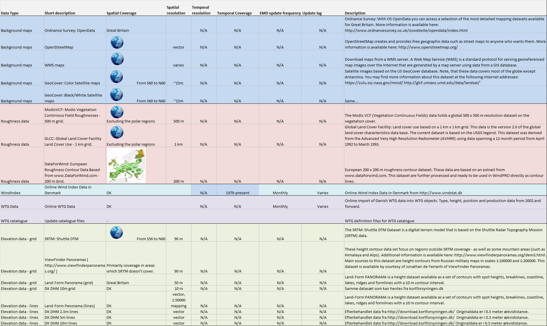
In the table below, you can find the complete list of online services and datasets available from within WindPRO. A graphical/tabular overview of the datasets with update frequencies, coverage and resolutions is also available for wind data and remaining data. In the section Other Sources we have added brief descriptions on datasets that you may download from external internet resources.