CFS- and CFSR Data
Introduction
The CFSR is a third generation reanalysis product. It is a global, high resolution, coupled atmosphere-ocean-land surface-sea ice system designed to provide the best estimate of the state of these coupled domains over this period. The CFSR includes (1) coupling of atmosphere and ocean during the generation of the 6 hour guess field, (2) an interactive sea-ice model, and (3) assimilation of satellite radiances.
Dataset Overview
- Content:: Renewable energy focused data subset of CFSR data at different spatial distributions and distributed through 3 individual datasets CFSR, CFSR-E and CFSv2.
- Spatial Resolution:
- CFSR-E: 0.5 degree resolution
- CFSR: 0.3 degree resolution
- CFSv2: 0.2 degree resolution
- Temporal Resolution: Hourly values.
- Coverage:
- Coverage is global for land-areas and coastal regions.
- In windPRO, offshore coverage is at a distance of approximately 50 km from any known coastlines.
- Period:
- CFSR-E: 1979-2018.02
- CFSR: 1979-2010
- CFSv2: 2011-present
- Update schedule:
- EMD updates the dataset once a month. Due to processing time, the data from the previous month is typically available with a delay of 2 weeks.
Notes:
- Currently all 3 datasets are available in WindPRO, but caution is advised when utilizing the CFSR-E data set. (See "Data Experiences below")
- The CFSR-E dataset is actually a version of the CFSR that has been extended with data from CFSv2. According to NCEP, this can be regarded as a 'seamless' extension (however, see our experiences below).
The Model
The CFSR global atmosphere resolution is ~38 km (T382) with 64 levels. The global ocean is 0.25° at the equator, extending to a global 0.5° beyond the tropics, with 40 levels. The global land surface model has 4 soil levels and the global sea ice model has 3 levels. The CFSR atmospheric model contains observed variations in carbon dioxide (CO2), together with changes in aerosols and other trace gases and solar variations. With these variable parameters, the analyzed state will include estimates of changes in the Earth system climate due to these factors.
More information available at: https://climatedataguide.ucar.edu/reanalysis/climate-forecast-system-reanalysis-cfsr
Data Availability in 0.5 degree Dataset
CFSR data on the 0.5 degree grid is commonly available within WindPRO with a time-tag of 1-2 months. This is due to the processing time of the data at NOAA and the subset-processing at EMD. When the data has been processed at EMD, then the following parameters are available from within the online-dataservices WindPRO.
| Parameter | Description | Unit |
|---|---|---|
| time | UTC time stamp | YYYY-MM-DD HH:MM |
| wSpeed.10 | Wind speed at 10 m above surface | m/s |
| wDir.10 | Wind direction at 10 m above surface | deg |
| wSpeedAtPressure.500 | Wind speed at 500 hPa pressure level (approx 5500 m) | m/s |
| wDirAtPressure.500 | Wind direction at 500 hPa pressure level (approx 5500 m) | deg |
| wSpeedAtPressure.850 | Wind speed at 850 hPa pressure level (approx. 1500 m) | m/s |
| wDirAtPressure.850 | Wind direction at 850 hPa pressure level (approx. 1500 m) | deg |
| temperatureAtPressure.1000 | Wind direction at 1000 hPa pressure level (approx. at sea level) | celcius |
Data Experiences
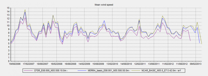
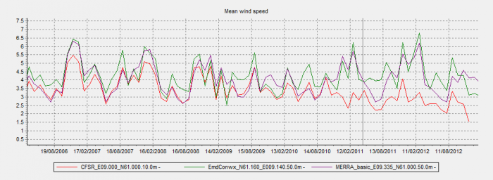
The CFSR-Extended dataset may suffer from inconsistencies if periods before and after end of 2010 are compared, even if NOAA has described the extended data as "seamless". Such inconsistencies are probably due to different native model resolutions of the CFSR and CFSv2 (0.3 degrees and 0.2 degrees). Please investigate this consistency issue thoroughly, if you are using CFSR-Extended data in your wind farm project.
Attribution
If data from this dataset is used within any private or public disseminations, then EMD and its data providers must be acknowledged.
Source: This dataset was developed at the Environmental Modeling Center at NCEP. Distribution through EMD and windPRO - EMD International A/S, 2020.
CFSR: Saha, Suranjana, and Coauthors, 2010: The NCEP Climate Forecast System Reanalysis. Bull. Amer. Meteor. Soc., 91, 1015.1057. doi: 10.1175/2010BAMS3001.1
CFS v2: Saha, Suranjana and Coauthors, 2014: The NCEP Climate Forecast System Version 2 Journal of Climate J. Climate, 27, 2185–2208. doi: http://dx.doi.org/10.1175/JCLI-D-12-00823.1
External Links
- The full CFSR data-set is available at UCAR http://rda.ucar.edu/pub/cfsr.html
- CFSR model description at NOAA: http://cfs.ncep.noaa.gov/cfsr/
- BAMS Paper on CFSR model by S. Shaha et al: The NCEP Climate Forecast System Reanalysis: http://journals.ametsoc.org/doi/pdf/10.1175/2010BAMS3001.1
- Description of CFSv2 Dataset at NCAR/UCAR: http://rda.ucar.edu/datasets/ds094.1/


