Difference between revisions of "European EMODnet Bathymetry"
(Created page with "This page will hold the description of the EMODnet Bathymetry.") |
|||
| Line 1: | Line 1: | ||
| − | + | [[Category: Online Data]][[Category: Digital Elevation Models]] | |
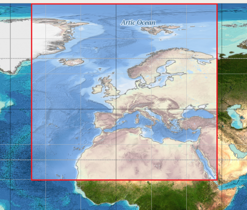
| + | [[Image:EMODNetBathymetryCoverage.png|right|thumb|500px|Coverage of the EMODnet Bathymetry DTM]] | ||
| + | == Introduction == | ||
| + | The EMODnet Bathymetry Digital Terrain Model (DTM) has been generated for European sea regions from selected bathymetric survey data sets, composite DTMs, Satellite Derive and Bathymetry (SDB) data products. Gaps with no data coverage are completed by integrating the GEBCO Digital Bathymetry. The DTM has a grid resolution of 1/8 * 1/8 arc minutes. | ||
| + | |||
| + | == Availability from within WindPRO == | ||
| + | The data is available directly from within windPRO and can be accessed from the online-services in the Elevation Grid Object. | ||
| + | |||
| + | == Reference System == | ||
| + | The following reference system was used in the original data: | ||
| + | * Geo [deg,min] - WGS84 | ||
| + | |||
| + | == License and Attribution == | ||
| + | Please use the following attribution when using this dataset: | ||
| + | |||
| + | EMODnet Bathymetry Consortium (2016): EMODnet Digital Bathymetry (DTM). | ||
| + | |||
| + | http://doi.org/10.12770/c7b53704-999d-4721-b1a3-04ec60c87238 | ||
| + | |||
| + | Additionally, there is a disclaimer: http://www.emodnet-bathymetry.eu/internal_html/disclaimer/10 | ||
| + | |||
| + | == Acknowledgement == | ||
| + | The European Marine Observation and Data Network (EMODnet) is thanked for producing this digital elevation dataset – and disseminating it in the public domain and thus for aiding the development of renewable energy. | ||
| + | |||
| + | == External Links == | ||
| + | Description of the EMODnet Bathymetry data set: http://www.emodnet-bathymetry.eu/data-products | ||
Revision as of 09:27, 18 February 2019
Introduction
The EMODnet Bathymetry Digital Terrain Model (DTM) has been generated for European sea regions from selected bathymetric survey data sets, composite DTMs, Satellite Derive and Bathymetry (SDB) data products. Gaps with no data coverage are completed by integrating the GEBCO Digital Bathymetry. The DTM has a grid resolution of 1/8 * 1/8 arc minutes.
Availability from within WindPRO
The data is available directly from within windPRO and can be accessed from the online-services in the Elevation Grid Object.
Reference System
The following reference system was used in the original data:
- Geo [deg,min] - WGS84
License and Attribution
Please use the following attribution when using this dataset:
EMODnet Bathymetry Consortium (2016): EMODnet Digital Bathymetry (DTM).
http://doi.org/10.12770/c7b53704-999d-4721-b1a3-04ec60c87238
Additionally, there is a disclaimer: http://www.emodnet-bathymetry.eu/internal_html/disclaimer/10
Acknowledgement
The European Marine Observation and Data Network (EMODnet) is thanked for producing this digital elevation dataset – and disseminating it in the public domain and thus for aiding the development of renewable energy.
External Links
Description of the EMODnet Bathymetry data set: http://www.emodnet-bathymetry.eu/data-products
