Difference between revisions of "German Saxony-Anhalt Elevation Models"
(Created page with "== Introduction == The elevation model of the German Bundesland of Saxony-Anhalt (Sachsen-Anhalt) is a digital terrain model produced from data originally obtained from the op...") |
|||
| Line 1: | Line 1: | ||
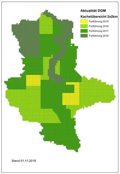
| + | [[Image:SaxonyAnhalt-Coverage.png|right|thumb|420px|Coverage of the DTM (DGM). Image credit: LVermGeo.]] | ||
== Introduction == | == Introduction == | ||
The elevation model of the German Bundesland of Saxony-Anhalt (Sachsen-Anhalt) is a digital terrain model produced from data originally obtained from the open geodata of Saxony-Anhalt. It is produced and delivered by the Landesamtes für Vermessung und Geoinformation Sachsen-Anhalt (LVermGeo). Two elevation models are delivered with windPRO: one at 5m resolution and one at 20m resolution. The original models are available at a maximum resolution of 2m, however, the highest resolution model in windPRO version is resampled by EMD to obtain a slightly coarser resolution - 5m. This is done in order for the data to be operational for the larger domains needed in the context of wind farm analysis’ and wind flow modelling. The resampling is made based on 2m data using a bi-linear interpolation algorithm. Data made available by EMD represents the data status of January 2021. | The elevation model of the German Bundesland of Saxony-Anhalt (Sachsen-Anhalt) is a digital terrain model produced from data originally obtained from the open geodata of Saxony-Anhalt. It is produced and delivered by the Landesamtes für Vermessung und Geoinformation Sachsen-Anhalt (LVermGeo). Two elevation models are delivered with windPRO: one at 5m resolution and one at 20m resolution. The original models are available at a maximum resolution of 2m, however, the highest resolution model in windPRO version is resampled by EMD to obtain a slightly coarser resolution - 5m. This is done in order for the data to be operational for the larger domains needed in the context of wind farm analysis’ and wind flow modelling. The resampling is made based on 2m data using a bi-linear interpolation algorithm. Data made available by EMD represents the data status of January 2021. | ||
Revision as of 19:19, 15 January 2021
Introduction
The elevation model of the German Bundesland of Saxony-Anhalt (Sachsen-Anhalt) is a digital terrain model produced from data originally obtained from the open geodata of Saxony-Anhalt. It is produced and delivered by the Landesamtes für Vermessung und Geoinformation Sachsen-Anhalt (LVermGeo). Two elevation models are delivered with windPRO: one at 5m resolution and one at 20m resolution. The original models are available at a maximum resolution of 2m, however, the highest resolution model in windPRO version is resampled by EMD to obtain a slightly coarser resolution - 5m. This is done in order for the data to be operational for the larger domains needed in the context of wind farm analysis’ and wind flow modelling. The resampling is made based on 2m data using a bi-linear interpolation algorithm. Data made available by EMD represents the data status of January 2021.
Dataset Overview
- Spatial Coverage: Bundesland of Saxony-Anhalt
- Resolution: 5m and 20m (in windPRO)
- Data-type: Digital Terrain Model (DTM)
- Coordinate system
- Horizontal: ETRS89/UTM32 (EPSG 25832)
- Vertical: DHHN2016 (EPSG 7837) - Deutsche Haupthöhennetz 2016
- Version: Data were downloaded in January 2021. Data originates from years 2015-2018, dependent on area (see map to the right).
- Accuracy:
- Vertical: For the 2m resolution dataset the vertical accuracy is stated to be ±0.15m
- Horizontal: N/A
