Difference between revisions of "METAR Data"
| Line 32: | Line 32: | ||
|height=500 | |height=500 | ||
|width=800 | |width=800 | ||
| − | |gkml=//www.emd.dk/download/Data/Stations9A.kmz }} | + | |gkml=http://www.emd.dk/download/Data/Stations9A.kmz }} |
</center> | </center> | ||
Revision as of 07:26, 1 June 2017
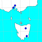
The NCEP ADP METAR (Aviation Routine Weather Report) dataset is based on measurements from various airports and permanent weather observation stations around the globe. Currently, about 5000 stations are included in this global dataset. An example of the spatial coverage is shown in the figure to the right for the available stations near Tasmania, Australia.
Data Example
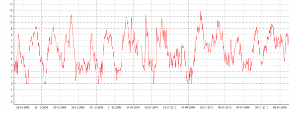
The purpose of the METARs is to provide guidance for pilots and the aviation industry, however some stations may also prove useful for the wind energy industry as reports of wind speed, wind direction and temperature are available, see the sample in the figure below.
Considerations
When applying this dataset, please consider the following issues:
- The reporting frequency varies: Some stations report a few days per year, others only during daytime hours, while others report continuously with 10, 30 minute or hourly intervals. Some stations may only report a period within the hour (e.g. last ten minutes).
- The position of the station may be uncertain. Typically latitude and longitude is only reported with an accuracy of two decimals (with position in decimal degrees).
- The height of the meteorological mast is uncertain, often 5, 10 or 30 meter masts are used; however the standard is 10 meters.
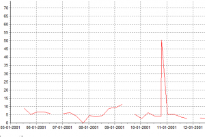
- Since an automated data collection procedure is used at NCAR; then errors may occur in data (such as spikes, see the figure right) and position encoding.
Please take proper care to validate the METAR data against local measurements and to validate the position against local maps. This dataset is processed by EMD and originates from the NCAR website. For further information about the METAR sites, please consider investigating the online resource at:
http://weather.gladstonefamily.net/site
If you enter the four digit ICAO airport code, you may see additional information about the airport of consideration. You can find the airport code in the source files header in the WindPRO meteo object.
Interactive Map of METAR and SYNOP stations
On the map below, you can click the station (blue=METAR, green=SYNOP) symbols to see more information on the site.
{{#display_map:centre=paris |minzoom=4 |maxzoom=8 |zoom=6 |height=500 |width=800 |gkml=http://www.emd.dk/download/Data/Stations9A.kmz }}
Abbreviations
WMO# = Station index number, assigned by the World Meteorologival Organization Network (WMO - www.wmo.ch).
ICAO# = Location indicator, assigned by the International Civil Aviation Organization (ICAO - www.icao.int).
CWOP = Citizen Weather Observation Programme. METAR = Aviation Routine Weather Report.
Data Source
WMO/ICAO Weather Station Information: Converted by EMD to kml-format for use in WindPRO (www.windpro.com).
Original information from http://weather.noaa.gov.
Acknowledgement
The METAR data are from the Research Data Archive (RDA) which is maintained by the Computational and Information Systems Laboratory (CISL) at the National Center for Atmospheric Research (NCAR). NCAR is sponsored by the National Science Foundation (NSF). The original data are available from the RDA (http://rda.ucar.edu) in dataset number ds461.0.


