Difference between revisions of "Main Page"
| (48 intermediate revisions by 3 users not shown) | |||
| Line 1: | Line 1: | ||
[[File:Windpro_v2_rgb.png|right|150px]] | [[File:Windpro_v2_rgb.png|right|150px]] | ||
| − | This WindPRO-Wiki currently contains a description of all the online-datasets that are available directly from within WindPRO. This wiki seeks to describe the remote sensing data and other data available for download or which can be accessed from WindPRO. Since more online-datasets become available in-between WindPRO releases, then [http://www.emd.dk EMD] has decided to release the online dataset documentation in a dynamic wiki-format. This enables a more dynamic (and frequent) update of the associated datasets and their documentation. | + | This WindPRO-Wiki currently contains a description of all the online-datasets that are available directly from within WindPRO. This wiki seeks to describe the remote sensing data and other data available for download or which can be accessed from WindPRO. Since more online-datasets become available in-between WindPRO releases, then [http://www.emd.dk EMD] has decided to release the online dataset documentation in a dynamic wiki-format. This enables a more dynamic (and frequent) update of the associated datasets and their documentation. This page describes the datasets available within WindPRO 3.3. |
| − | + | We welcome suggestions for new datasets to integrate with windPRO: Please submit any proposals at [https://tinyurl.com/new-windpro-dataset this feedback form]. | |
| − | |||
== [[:Category:Online Data|WindPRO Documentation on Online Data]] == | == [[:Category:Online Data|WindPRO Documentation on Online Data]] == | ||
| Line 12: | Line 11: | ||
|- valign="top" | |- valign="top" | ||
|'''[[:Category:Digital Elevation Models|Global & Regional Digital Elevation Models (DEM)]]'''<br><hr> | |'''[[:Category:Digital Elevation Models|Global & Regional Digital Elevation Models (DEM)]]'''<br><hr> | ||
| − | * [[EU-DEM|European Elevation Model - | + | * [[Global_AW3D30|ALOS World 3D 30m mesh (AW3D30)]] |
| + | * [[EU-DEM|European Elevation Model (EU-DEM)]] | ||
| + | * [[NASA-DEM|NASADEM (successor of SRTM)]] | ||
* [[Shuttle_Radar_Topography_Mission|Shuttle Radar Topography Mission (SRTM)]] | * [[Shuttle_Radar_Topography_Mission|Shuttle Radar Topography Mission (SRTM)]] | ||
| − | * [[Viewfinder_Panoramas|Viewfinder Panoramas DEM]] | + | * [[Viewfinder_Panoramas|Viewfinder Panoramas DEM]]<br><br> |
| − | <br> | ||
'''[[:Category:Digital Elevation Models|National Digital Elevation Models (DEM)]]'''<br><hr> | '''[[:Category:Digital Elevation Models|National Digital Elevation Models (DEM)]]'''<br><hr> | ||
* [[Austrian_Elevation_Model|Austrian Elevation Model (DGM)]] | * [[Austrian_Elevation_Model|Austrian Elevation Model (DGM)]] | ||
| + | * [[Australian_Elevation_Models|Australian Elevation Models]] | ||
* [[Belgium-Flemish_Elevation_Models|Belgium Flemish Elevation Model (DTM)]] | * [[Belgium-Flemish_Elevation_Models|Belgium Flemish Elevation Model (DTM)]] | ||
| + | * [[Belgium-Walloon_Elevation_Models|Belgium Walloon Elevation Models (MNT)]] | ||
* [[Danish_Elevation_Model|Danish Elevation Model (Danmarks Højdemodel)]] | * [[Danish_Elevation_Model|Danish Elevation Model (Danmarks Højdemodel)]] | ||
| + | * [[Estonian_Elevation_Models|Estonian Elevation Models]] | ||
* [[Finnish Elevation Model|Finnish Elevation Model]] | * [[Finnish Elevation Model|Finnish Elevation Model]] | ||
* [[French_Elevation_Models|French Elevation Models]] | * [[French_Elevation_Models|French Elevation Models]] | ||
| Line 25: | Line 28: | ||
* [[Italy-Sardinia_Elevation_Model|Italian-Sardinia Elevation Model]] | * [[Italy-Sardinia_Elevation_Model|Italian-Sardinia Elevation Model]] | ||
* [[Italy-Tuscany_Elevation_Model|Italian-Tuscany Elevation Model]] | * [[Italy-Tuscany_Elevation_Model|Italian-Tuscany Elevation Model]] | ||
| − | |||
* [[Latvian_Elevation_Model|Latvian Elevation Model]] | * [[Latvian_Elevation_Model|Latvian Elevation Model]] | ||
* [[Luxembourg_Elevation_Model|Luxembourg Elevation Model (BD-L-MNT5)]] | * [[Luxembourg_Elevation_Model|Luxembourg Elevation Model (BD-L-MNT5)]] | ||
| Line 37: | Line 39: | ||
* [[OSNI-Open-Data|UK - Northern Ireland Elevation Model - OSNI]] | * [[OSNI-Open-Data|UK - Northern Ireland Elevation Model - OSNI]] | ||
* [[UK-Wales_Elevation_Model|UK - Wales Elevation Model]] | * [[UK-Wales_Elevation_Model|UK - Wales Elevation Model]] | ||
| − | * [[National_Elevation_Dataset|US National Elevation Dataset (NED)]] | + | * [[National_Elevation_Dataset|US National Elevation Dataset (NED)]]<br><br> |
| − | |||
| − | <br> | ||
'''[[:Category:Digital_Roughness_Data|Digital Roughness Models (DRM)]]'''<br><hr> | '''[[:Category:Digital_Roughness_Data|Digital Roughness Models (DRM)]]'''<br><hr> | ||
| − | * [[ | + | * [[Copernicus_Global_Land_Service_-_Land_Cover_100m|Copernicus Global Land Service, Land Cover 100]] |
| + | * [[Corine_Land_Cover|Corine Land Cover (2006, 2012 and 2018)]] | ||
* [[Data_For_Wind|European Data For Wind]] | * [[Data_For_Wind|European Data For Wind]] | ||
* [[Global_Land_Cover_Characteristics|Global Land Cover Characteristics (GLCC)]] | * [[Global_Land_Cover_Characteristics|Global Land Cover Characteristics (GLCC)]] | ||
* [[Glob_Cover|GlobCover]] | * [[Glob_Cover|GlobCover]] | ||
| − | * [[ | + | * [[MODIS_VCF|MODIS VCF]] |
| − | * [[National_Land_Cover_Database_2011|National Land Cover Database 2011 | + | * [[National_Land_Cover_Database_2011|US National Land Cover Database 2011]] |
| − | |||
|'''[[:Category:Wind Data|Wind Data]]'''<br><hr> | |'''[[:Category:Wind Data|Wind Data]]'''<br><hr> | ||
| − | |||
| − | |||
| − | |||
* [[Blended_Coastal_Winds|Blended Coastal Winds]] | * [[Blended_Coastal_Winds|Blended Coastal Winds]] | ||
| − | |||
| − | |||
| − | |||
| − | |||
* [[CFS-_and_CFSR_Data|CFS- and CFSR Data]] | * [[CFS-_and_CFSR_Data|CFS- and CFSR Data]] | ||
* [[Danish Windindex Data]] | * [[Danish Windindex Data]] | ||
* [[ERA-Interim|EMD-Global Wind Data (based on ERA-Interim)]] | * [[ERA-Interim|EMD-Global Wind Data (based on ERA-Interim)]] | ||
| − | * [[ERA5 | + | * [[ERA5_Gaussian_Grid|ERA5 Gaussian Grid]] |
| − | * [[KNMI_North_Sea_Wind_(KNMI-KNW)|KNMI-KNW North Sea Wind]]<br><br> | + | * [[ERA5(T)_Rectangular_Grid|ERA5(T) Rectangular Grid]] |
| + | * [[KNMI_North_Sea_Wind_(KNMI-KNW)|KNMI-KNW North Sea Wind]] | ||
| + | * [[MERRA_Data|MERRA Data]] | ||
| + | * [[MERRA2_Data|MERRA-2 Data]] | ||
| + | * [[METAR_Data|METAR Data]] | ||
| + | * [[NCEP_/_NCAR_Global_Reanalysis_Data|NCEP/NCAR Global Reanalysis Data]] | ||
| + | * [[NCEP_North_American_Regional_Reanalysis_Data|North American Regional Reanalysis Data]] | ||
| + | * [[QuikScat|QuikScat Offshore Wind Dataset]] | ||
| + | * [[SYNOP_Data|SYNOP Data]]<br><br> | ||
'''[[:Category:Wind Data|EMD-WRF Mesoscale Wind Data]]'''<br><hr> | '''[[:Category:Wind Data|EMD-WRF Mesoscale Wind Data]]'''<br><hr> | ||
* [[EMD-WRF_Europe%2B|Europe]]: EMD-WRF Europe+ (ERA5) | * [[EMD-WRF_Europe%2B|Europe]]: EMD-WRF Europe+ (ERA5) | ||
* [[EMD-ConWx_Meso_Data_Europe|Europe]]: EMD-ConWx Europe (ERA-Interim) | * [[EMD-ConWx_Meso_Data_Europe|Europe]]: EMD-ConWx Europe (ERA-Interim) | ||
* [[EMD-WRF Middle East|Middle East]]: EMD-WRF Middle East Meso Data | * [[EMD-WRF Middle East|Middle East]]: EMD-WRF Middle East Meso Data | ||
| − | * [[EMD-WRF South Korea|South Korea]]: EMD-WRF South Korea | + | * [[EMD-WRF_South_Korea_(ERA5)|South Korea]]: EMD-WRF South Korea (ERA5) |
| + | * [[EMD-WRF South Korea|South Korea]]: EMD-WRF South Korea, ERA-Interim | ||
* [[EMD-WRF South Africa|South Africa]]: EMD-WRF South Africa Meso Data | * [[EMD-WRF South Africa|South Africa]]: EMD-WRF South Africa Meso Data | ||
* [[EMD-WRF India|India]]: EMD-WRF India Meso Data | * [[EMD-WRF India|India]]: EMD-WRF India Meso Data | ||
* [[EMD-WRF Indonesia|Indonesia]]: EMD-WRF Indonesia Meso Data | * [[EMD-WRF Indonesia|Indonesia]]: EMD-WRF Indonesia Meso Data | ||
| − | * [[EMD-WRF_On-Demand|On Demand]]: EMD-WRF Global Meso On-Demand | + | * [[EMD-WRF_On-Demand|On Demand]]: EMD-WRF Global Meso On-Demand<br><br> |
| − | <br> | + | '''[[:Category:Solar Data|Solar Irradiance Data]]'''<br><hr> |
| + | * [[Heliosat_(SARAH)|Heliosat (SARAH)]] | ||
| + | * [[Heliosat_(SARAH)_East|Heliosat (SARAH) East]]<br><br> | ||
'''[[:Category:Existing_Turbines|Databases on Turbines]]'''<br><hr> | '''[[:Category:Existing_Turbines|Databases on Turbines]]'''<br><hr> | ||
| − | |||
* [[Danish_Wind_Turbines|Danish Turbines (makes, positions, productions)]] | * [[Danish_Wind_Turbines|Danish Turbines (makes, positions, productions)]] | ||
| + | * [[Finnish_Wind_Turbines|Finnish Turbines (positions)]] | ||
| + | * [[DE_Wind_Turbines_MaStR|German MaStR Turbines (types, positions)]] | ||
* [[OSM_Turbines|Open Streep Map Turbines (positions only)]] | * [[OSM_Turbines|Open Streep Map Turbines (positions only)]] | ||
* [[US_Wind_Turbines|Turbines in the United States]] | * [[US_Wind_Turbines|Turbines in the United States]] | ||
| − | * [[ | + | * [[WTG_Catalogue|WindPRO Wind Turbine Catalogue]] |
| − | |'''[[:Category:Maps|Digital Map Data]]'''<br><hr> | + | |'''[[:Category:Maps|Digital Map Data - Orthophotos]]'''<br><hr> |
| − | |||
* [[Danish_Orthophoto_Mosaic|Danish Orthophoto Mosaic]] | * [[Danish_Orthophoto_Mosaic|Danish Orthophoto Mosaic]] | ||
| − | |||
| − | |||
* [[French_Orthophoto_Mosaic|French Orthophoto Mosaic]] | * [[French_Orthophoto_Mosaic|French Orthophoto Mosaic]] | ||
| + | * [[Finnish_Orthophoto_Mosaic|Finnish Orthophoto Mosaic]] | ||
| + | * [[Latvian_Orthophoto_Mosaic|Latvian Orthophoto Mosaic]] | ||
| + | * [[Spanish_Orthophoto_Mosaic|Spanish Orthophoto Mosaic]] | ||
| + | * [[GeoCover_Images|GeoCover Images]] | ||
| + | * [[WindPRO_Global_Satellite_Imagery|windPRO Global Satellite Imagery - 10m]] | ||
| + | * [[WindPRO_European_Satellite_Imagery|windPRO European Satellite Imagery - 2.5m]]<br><br> | ||
| + | '''[[:Category:Maps|Digital Map Data - Topographic Maps]]'''<br><hr> | ||
| + | * [[OS_OpenData|British Ordnance Survey OpenData]] | ||
| + | * [[Estonian_Topographic_Map|Estonian Topographic Map]] | ||
| + | * [[German Topographic Maps]] | ||
* [[French_Raster_Map|French Raster Map]] | * [[French_Raster_Map|French Raster Map]] | ||
| − | |||
* [[Finnish_Topographic_Map|Finnish Topographic Map]] | * [[Finnish_Topographic_Map|Finnish Topographic Map]] | ||
| + | * [[Latvian_Topographic_Map|Latvian Topographic Map]] | ||
* [[Spanish_Topographic_Map|Spanish Topographic Map]] | * [[Spanish_Topographic_Map|Spanish Topographic Map]] | ||
| − | |||
| − | |||
* [[Open_Street_Map|Open Street Map]] | * [[Open_Street_Map|Open Street Map]] | ||
| − | * [[OnMaps|OnMaps]] | + | * [[OnMaps|OnMaps]]<br><br> |
| − | |||
| − | |||
| − | |||
| − | <br> | ||
'''[[:Category:Forest_Maps|Forest Maps (Canopy/Tree Heights)]]'''<br><hr> | '''[[:Category:Forest_Maps|Forest Maps (Canopy/Tree Heights)]]'''<br><hr> | ||
| + | * [[Danish_KU_Forest_Heights|Danish KU Forest Map]] | ||
* [[Estonian_Canopy_Heights|Estonian Forest Map]] | * [[Estonian_Canopy_Heights|Estonian Forest Map]] | ||
* [[Finnish_LUKE_Forest_Map|Finnish LUKE Forest Map]] | * [[Finnish_LUKE_Forest_Map|Finnish LUKE Forest Map]] | ||
| + | * [[Latvian_Canopy_Heights|Latvian Canopy Heights]] | ||
| + | * [[Norwegian_SR16_Forest_Heights|Norwegian SR16 Forest Map]] | ||
* [[Swedish_SLU_Forest_Map|Swedish SLU Forest Map]] | * [[Swedish_SLU_Forest_Map|Swedish SLU Forest Map]] | ||
| Line 106: | Line 115: | ||
* [[Global_Bathymetry_GEBCO|Global Bathymetry - GEBCO - 2019 & 2014]] | * [[Global_Bathymetry_GEBCO|Global Bathymetry - GEBCO - 2019 & 2014]] | ||
<br> | <br> | ||
| − | <span style="color:#FF4D00">'''Other Data Sources'''</span><br><hr> | + | <span style="color:#FF4D00">'''Other Maps, Tools and Data Sources'''</span><br><hr> |
| + | * [[Commercial_DEM_Providers|3rd Party Commercial DEM Providers]] | ||
| + | * [[Aster_Global_Digital_Elevation_Model|Aster Global Elevation Model (Aster GDEM)]] | ||
* [[CGIAR_SRTM_90m_Digital_Elevation_Data|CGIAR 90m Digital Elevation Data.]] | * [[CGIAR_SRTM_90m_Digital_Elevation_Data|CGIAR 90m Digital Elevation Data.]] | ||
| − | * [[ | + | * [[_Innowind_Premium_Data_Layers|DHI-GRAS Premium Innowind Data Layers]] |
| + | * [[Dynamic_maps|Dynamic maps]] | ||
| + | * [[Google_Earth_Export|Export of WindPRO data into Google Earth]] | ||
| + | * [[ÜSTÜN_windPROSPER_maps|ÜSTÜN windPROSPER maps]] | ||
| + | * [[Web_Map_Service|Web Map Service (WMS)]] | ||
| + | * [[MERIT_DEM|MERIT-DEM - Digital Elevation Model - 90m]] | ||
|} | |} | ||
Revision as of 13:11, 10 June 2020

This WindPRO-Wiki currently contains a description of all the online-datasets that are available directly from within WindPRO. This wiki seeks to describe the remote sensing data and other data available for download or which can be accessed from WindPRO. Since more online-datasets become available in-between WindPRO releases, then EMD has decided to release the online dataset documentation in a dynamic wiki-format. This enables a more dynamic (and frequent) update of the associated datasets and their documentation. This page describes the datasets available within WindPRO 3.3. We welcome suggestions for new datasets to integrate with windPRO: Please submit any proposals at this feedback form.
WindPRO Documentation on Online Data
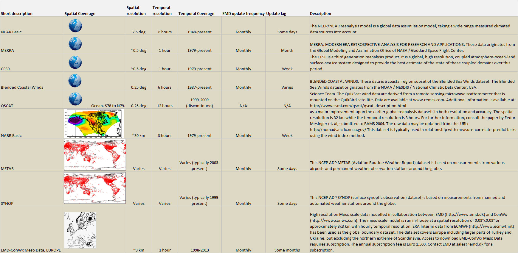
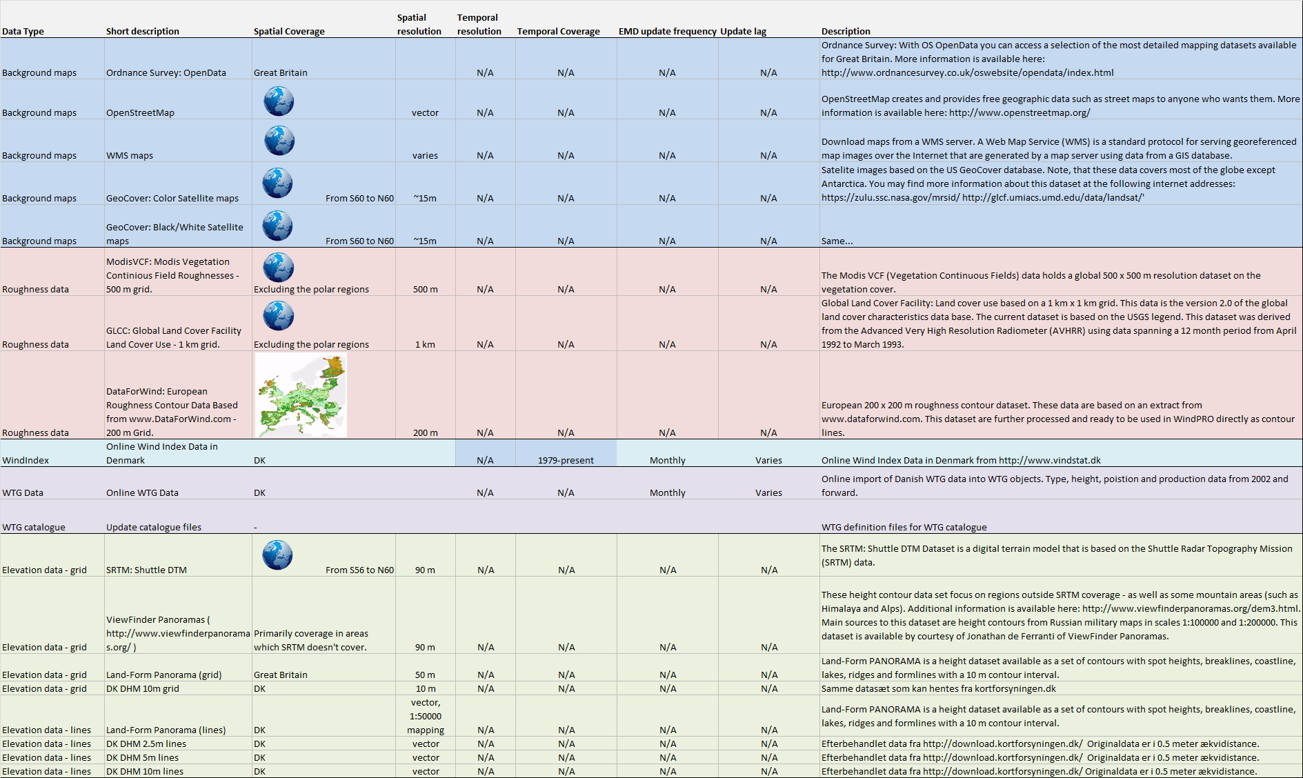
In the table below, you can find the complete list of online services and datasets available from within WindPRO. A graphical/tabular overview of the datasets with update frequencies, coverage and resolutions is also available for wind data and remaining data. In the section Other Sources we have added brief descriptions on datasets that you may download from external internet resources.