Difference between revisions of "New European Wind Atlas (NEWA)"
m (→Introduction) |
|||
| Line 3: | Line 3: | ||
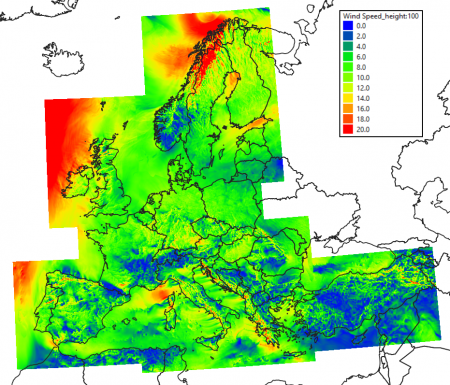
[[Image:NEWA-map-with-legend.png|right|thumb|450px|Spatial domain for the NEWA mesoscale data. Image showing wind speeds on November 17th 2018.]] | [[Image:NEWA-map-with-legend.png|right|thumb|450px|Spatial domain for the NEWA mesoscale data. Image showing wind speeds on November 17th 2018.]] | ||
==Introduction== | ==Introduction== | ||
| − | The New European Wind Atlas (NEWA) is a high resolution mesoscale dataset that was modelled and provided by the NEWA consortium. NEWA was established as a ERANET+ project with a total budget of 13.1 million euros and it was executed over the years 2016-2019. One of the project outcomes was a comprehensive mesoscale modelling with a spatial coverage of the whole of the European Union and Turkey - and extending at least 100km from any known coastlines. 10 years of data has been made available in a temporal resolution of 30 minutes. | + | The New European Wind Atlas (NEWA) is a high resolution mesoscale dataset that was modelled and provided by the NEWA consortium. NEWA was established as a ERANET+ project with a total budget of 13.1 million euros and it was executed over the years 2016-2019. One of the project outcomes was a comprehensive mesoscale modelling with a spatial coverage of the whole of the European Union and Turkey - and extending at least 100km from any known coastlines. 10 years of data has been made available in a temporal resolution of 30 minutes. A total of 1.37 million individual data-nodes (points) a available. |
===Dataset Overview=== | ===Dataset Overview=== | ||
| − | * '''Content:''' Limited feature subset of the NEWA mesoscale dataset. | + | * '''Content:''' Limited feature subset of the NEWA mesoscale dataset - but full spatial coverage (1.37 million nodes). |
* '''Spatial resolution:''' 3km | * '''Spatial resolution:''' 3km | ||
* '''Temporal resolution:''' Timestep 30 minutes | * '''Temporal resolution:''' Timestep 30 minutes | ||
Revision as of 10:04, 14 October 2021
Note: This dataset is currently being integrated into windPRO 3.5.
Introduction
The New European Wind Atlas (NEWA) is a high resolution mesoscale dataset that was modelled and provided by the NEWA consortium. NEWA was established as a ERANET+ project with a total budget of 13.1 million euros and it was executed over the years 2016-2019. One of the project outcomes was a comprehensive mesoscale modelling with a spatial coverage of the whole of the European Union and Turkey - and extending at least 100km from any known coastlines. 10 years of data has been made available in a temporal resolution of 30 minutes. A total of 1.37 million individual data-nodes (points) a available.
Dataset Overview
- Content: Limited feature subset of the NEWA mesoscale dataset - but full spatial coverage (1.37 million nodes).
- Spatial resolution: 3km
- Temporal resolution: Timestep 30 minutes
- Coverage: European Union and Turkey (see the map to the right)
- Period: 10 years of data from 2009-01-01 to 2018-12-31
- Update schedule: This dataset is not updated
Usage Notes
- Interested in other parameters: See a complete list and download these directly from the NEWA homepage: https://map.neweuropeanwindatlas.eu (time-series download is not directly possible)
- The mesoscale modelling in the NEWA project covered 30 years (1989-2018) - but currenly only the last 10 years has been made available to the public.
- Data validation: NEWA data was included as part the EMD data benchmarks for the EMD-WRF Europe+ dataset. Here different reanalysis and mesoscale data sources were compared to 300+ high-quality masts within the european domain. The validation report is freely available - here.
Dataset Parameters
The following parameters are available from the NEWA mesoscale data-subset in windPRO:
| Parameter(s) | Description | Unit |
|---|---|---|
| time | UTC time stamp | YYYY-MM-DD HH:MM |
| T.100, T.200 | Temperature in 100m and 200m agl | degK |
| TKE.100 | Turbulent Kinetic Energy in 100m agl | (m/s)^2 |
| WD.100, WD.200 | Wind direction in 100m and 200m agl | deg |
| WS.100, WS.200 | Wind speed in 100m and 200m agl | m/s |
License and Attribution
This dataset is a subset of the NEWA mesoscale dataset that has been released under the Creative Commons By Atrribution 4.0 license (CC-BY-40) - https://creativecommons.org/licenses/by/4.0/. As a part of the license conditions, the data-owner requires an attribution, such as:
Source:
Data obtained from the “New European Wind Atlas, a free, web-based application developed, owned and operated by the NEWA Consortium.
For additional information see www.neweuropeanwindatlas.eu". Distribution through EMD and windPRO - EMD International A/S, 2021.
Required windPRO License and Modules
This dataset can be accessed from the most recent version of windPRO given that you hold an active service agreement and a license to the following modules:
- Basis
- Meteo
External Links and References
- NEWA - main homepage: https://www.neweuropeanwindatlas.eu
- NEWA - map and data: https://map.neweuropeanwindatlas.eu
- NEWA - Model setup: https://map.neweuropeanwindatlas.eu/about
- NEWA - Mesoscale publication: https://zenodo.org/record/2682604#.YT7qZH3RYUE
Acknowledgement and Credits
- Credits and Acknowledgement: The NEWA Consortium for the release of the NEWA mesoscale datasset as a free and open dataset.
- Integration of this dataset into EMD services was co-supported through the RECAST project (http://www.recastproject.dk) which is co-funded by the Danish Innovation Fund
