Difference between revisions of "Taiwan Elevation Model"
Jump to navigation
Jump to search
m (→Introduction) |
m (→Usage Notes) |
||
| Line 14: | Line 14: | ||
== Usage Notes == | == Usage Notes == | ||
| − | * ''Question'': In the original data - a small part of the model is missing between Hsinchu and Miaoli? ''Answer'': According to the National Development Council, this is due to air traffic control restrictions within that area of approximately 12km x 12km in size. Thus, no official elevation information is available. In order to make the model delivered with windPRO complete, EMD has patched this particular (small) part with data from the [[Copernicus_DEM|Copernicus GLO-30 m]]. | + | * ''Question'': In the original data - a small part of the model is missing between Hsinchu county and Miaoli (see image to the right, marked with red arrow)? ''Answer'': According to the National Development Council, this is due to air traffic control restrictions within that area of approximately 12km x 12km in size. Thus, no official elevation information is available. In order to make the model delivered with windPRO complete, EMD has patched this particular (small) part with data from the [[Copernicus_DEM|Copernicus GLO-30 m]]. |
* ''Question'': Is other versions of the Taiwan elevation models available? ''Answer'': Yes, the National Development Council of Taiwan has also released elevation models with version years 2016 and 2018. If you need those, please consult the website for the National Development Council of Taiwan - see the external links below. | * ''Question'': Is other versions of the Taiwan elevation models available? ''Answer'': Yes, the National Development Council of Taiwan has also released elevation models with version years 2016 and 2018. If you need those, please consult the website for the National Development Council of Taiwan - see the external links below. | ||
Revision as of 23:11, 30 May 2022
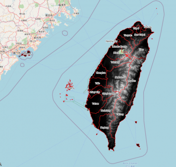
File:TaiwanDTM WindPROExample.png
Example of Taiwan DTM in windPRO.
Introduction
Taiwan Elevation Model 2020 - 20m resolution:
The National Development Council of Taiwan has released a digital elevation model (DTM) that covers the region of Taiwan. Most parts of the main island of Taiwan are covered, along with some outlying islands (Guishan Island, Green Islands, Orchid Islands & Xiao Liu Qiu (Liuqiu))
Dataset Overview
- Spatial Coverage: Taiwan, Kinmen (Golden Gate), Penghu and other minor outlying islands.
- Resolution: 20m
- Data type: Digital Terrain Model (DTM)
- Coordinate System: TWD97 (EPSG:3826) - in original data.
- Version: 2020 (with data accessed in spring 2022)
- Vertical accuracy: N/A
Usage Notes
- Question: In the original data - a small part of the model is missing between Hsinchu county and Miaoli (see image to the right, marked with red arrow)? Answer: According to the National Development Council, this is due to air traffic control restrictions within that area of approximately 12km x 12km in size. Thus, no official elevation information is available. In order to make the model delivered with windPRO complete, EMD has patched this particular (small) part with data from the Copernicus GLO-30 m.
- Question: Is other versions of the Taiwan elevation models available? Answer: Yes, the National Development Council of Taiwan has also released elevation models with version years 2016 and 2018. If you need those, please consult the website for the National Development Council of Taiwan - see the external links below.
Availability from within WindPRO
The data are available directly from within windPRO in 10-meter resolution. The data can be accessed from the online-services in the following objects:
- Line Object (with purpose to height contour lines)
- Elevation Grid Object
Acknowledgement
- The The National Development Council of Taiwan are thanked for producing this digital elevation dataset – and disseminating it in the public domain and thus for aiding the development of renewable energy - and wind energy in particular.
License
The product belongs to the open geo-data of Taiwan - and it was released from the National Development Council of Taiwan follwing an . An attribution must be made when using data, such as:
Contains data from the National Development Council of Taiwan: 2022 - Taiwan Elevation Model 2020.
Distribution through EMD and windPRO. License: Open Government Data License: https://data.gov.tw/license.
