UK-Scotland Elevation Model (LIDAR)
Introduction
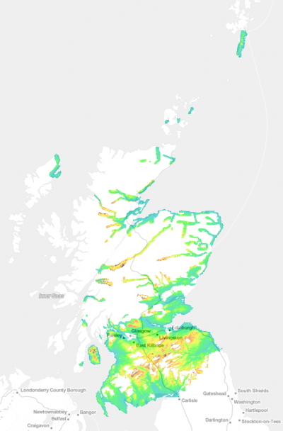
The UK - Scotland Elevation Model (LIDAR) in 5m grid resolution is a composite digital terrain model (DTM) produced from multiple surveys of high resolution LiDAR scans. The sources of data are the Scottish Government, the Scottish Environment Protection Agency, Scottish Water, Scottish Power Network and the UK Environment Agency. The composite model has been made by EMD International for use in windPRO and renewable energy applications. The original surveys are available at different resolutions: from 0.25m to 2.0m grid resolutions. The derived, composite elevation model delivered with windPRO is at 5m resolution (resampled with bi-linear interpolation). For wind energy modelling, we typically need a more coarse model (5-10m grid resolution) for the data to be operational for the large areas needed. The surveyed areas covers approximately 48,000 km² of the Scottish Territory.
Dataset Overview
- Spatial Coverage: See image to the right.
- Resolution: 5 m
- Data-type: Digital Terrain Model (DTM)
- Coordinate system (original data):
- Horizontal: OSGB36 British National Grid (EPSG: 27700)
- Vertical: Elevations recorded above Ordnance Datum Newlyn
- Version: Data downloaded in December 2020.
- Vertical Accuracy: N/A (but as LiDAR data in the centimeter-range)
- Survey Period: The composite contains data from surveys undertaken from 2000 until 2019.
Composite Dataset Sources
As mentioned above, this dataset is a composite model with data originating from multiple sources and campaigns. The list below outlines the different data sources and a few key parameters:
- Scottish Public Sector LiDAR (Phase I): 11,845 km2 - Period 2011 to 2012 - 10 sites for flood risk management - 382 data tiles - based on 1m data
- Scottish Public Sector LiDAR (Phase II): 3,516 km2 - Period 2012 to 2014 - 66 sites for flood risk management - 232 data tiles - based on 1m data
- Scottish Public Sector LiDAR (Phase III): 11,772 km2 - Period 2015 to 2016 - Overhead power cable network survey - 674 data tiles - based on 50cm data
- Scottish Public Sector LiDAR (Phase IV): 17,945 km2 - Period 2017 to 2019 - Overhead power cable network - 420 data tiles - based on 50cm data
- UK Environment Agency LiDAR composite: 3,025 km2 - Period 2000 to 2015 - UK Environment Agency surveys - 121 data tiles - based on 0.25-2.0m data
Most of the individual datasets are stored as individual tiles of size 10km x 10km or 5km x 5km. If multiple sources hold data within the same tile; then these are merged in order to get a maximum coverage over as wide an area as possible given the available data.
Usage Notes
- Since only about half of the territory is covered by the LiDAR scans - you may need to void-fill some areas. If you download the data into an elevation grid object, these void-areas can easily be filled with other readily available sources such as the 50m gridded data from OS Land Form or OS Terrain 50.
- Higher resolution data exist for selected areas in the region based on more recent LiDAR surveys: These are in resolutions from 0.25m to 2m – and may be accessed directly from the UK Open Data web-site or the Scottish Remote Sensing web-site (see links below).
Availability from within windPRO
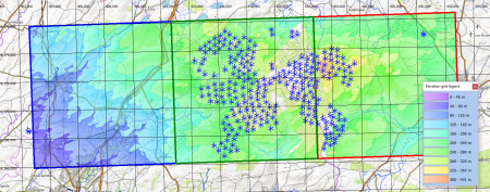
The data are available directly from within windPRO in 5-meter grid resolution. The data can be accessed from the online-services in the following objects:
- Line Object (with purpose set to height contour lines)
- Elevation Grid Object
License and Attribution
The product belongs to the open geospatial data of the Scottish Government and UK Environmental Agency. All the data used for the composite elevation model are licensed under a under a ‘Open Government License for Public Sector Information v. 3.0’. A copy of this license is available from The National Archives, here. This license is compatible with the Creative Commons Attribution License 4.0.
LICENSE:
Contains public sector information licensed under the Open Government Licence v3.0: http://www.nationalarchives.gov.uk/doc/open-government-licence/version/3/
Please use the following attribution when using this dataset:
ATTRIBUTION:
Contains public sector information licensed under the Open Government Licence v3.0.
This composite elevation dataset was created by EMD and distributed through windPRO. It originates from multiple sources acknowledged here:
Scottish Public Sector LiDAR (Phase I): Crown copyright Scottish Government, SEPA and Scottish Water (2012).
Scottish Public Sector LiDAR (Phase II): Crown copyright Copyright Scottish Government and SEPA (2014).
Scottish Public Sector LiDAR (Phase III): Crown copyright Scottish Government, SEPA and Fugro (2020)
Scottish Public Sector LiDAR (Phase IV): Crown copyright Scottish Government, SEPA and Fugro (2020)
UK Environment Agency LiDAR composite: © Environment Agency copyright and/or database right 2016. All rights reserved.
Acknowledgement
- The Scottish Government, Scottish Environment Protection Agency, Scottish Water, Scottish Power Network and the public of Scotland are thanked for producing this digital elevation dataset – and disseminating it in the public domain and thus for aiding the development of renewable energy.
- The Environment Agency and the public of England are thanked for producing this digital elevation dataset – and disseminating it in the public domain and thus for aiding the development of renewable energy.

