Category:Digital Elevation Models: Difference between revisions
| (15 intermediate revisions by 2 users not shown) | |||
| Line 1: | Line 1: | ||
[[Category:Online Data]] | [[Category:Online Data]] | ||
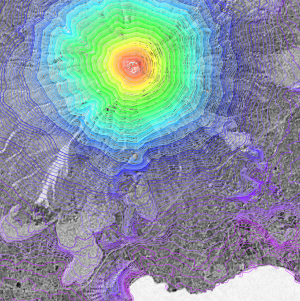
[[File:ExampleSRTM.png|left|thumb|300px|Satellite Image with DEM Overlay. The image shows a part of the Ometepe Island in Lake Nicaragua with SRTM height contour data.]] | [[File:ExampleSRTM.png|left|thumb|300px|Satellite Image with DEM Overlay. The image shows a part of the Ometepe Island in Lake Nicaragua with SRTM height contour data.]] | ||
==Introduction== | ==Introduction== | ||
The digital | The digital elevation models in WindPRO are based on many different national and global sources. Currently, the best (highest quality) globally-available DEM source is the [[Copernicus_DEM|CopernicusDEM]] 30m resolution data - this model was released in 2021. Before 2021, the default choice for a global elevation model was the Shuttle Radar Topography Mission (SRTM) data - in its 1-arc-second resolution. More countries are releasing national data under open-data licenses. Typically these have a much better resolution than CopernicusDEM or SRTM - and it is often recommended to use local sources for DEM modelling - if such higher-quality are available for a particular site. | ||
==Let us know!== | ==Let us know!== | ||
EMD and the windPRO team are | EMD and the windPRO team are continuously working to add better and higher quality DEMs into the data-services of windPRO. So: Please let us know if you know of data-sources that you would like to see included in windPRO. Just drop us an email at support@emd.dk. | ||
== Considerations == | |||
When using the remote sensing digital height models, you must manually consider the accuracy of the dataset used. This is especially important in the vicinity of the wind farm and other associated objects such as meteorological masts, noise and shadow receptors and photomontage viewpoints. Typically – when applying remote sensing | When using the remote sensing digital height models, you must manually consider the accuracy of the dataset used. This is especially important in the vicinity of the wind farm and other associated objects such as meteorological masts, noise and shadow receptors and photomontage viewpoints. Typically – when applying remote sensing DEMs - the height contour lines must be validated against a local topographical map. In addition, many of the wiki-pages in here provide links to further documentation and an overview of vertical and horizontal acurracy. | ||
== What type of elevation model? DEM, DSM and DTM? == | == What type of elevation model? DEM, DSM and DTM? == | ||
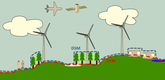
[[File:ElevationModels_DSM-DTM-DEM_2019.png|right|thumb|550px|Figure showing concepts of DEM, DSM and DTM.]] | [[File:ElevationModels_DSM-DTM-DEM_2019.png|right|thumb|550px|Figure showing concepts of DEM, DSM and DTM.]] | ||
For wind energy applications, it is important to | For wind energy applications, it is important to understand if the elevation model is a DEM, DSM or a DTM - so if objects (like buildings or trees) have been included in the model. In windPRO we use the following abbreviations when dealing with DEMs. | ||
1. DEM (Digital Elevation Model) - Is often used as a generic term for both | 1. DEM (Digital Elevation Model) - Is often used as a generic term for both DSMs and DTMs. <br> | ||
<span style="color:#36c">2. DSM (Digital Surface Model) - Is a surface representation ''with'' objects.</span><br> | <span style="color:#36c">2. DSM (Digital Surface Model) - Is a surface representation ''with'' objects.</span><br> | ||
<span style="color:#FF0000">3. DTM (Digital Terrain Model) - Is the bare earth representation ''without'' objects. </span> | <span style="color:#FF0000">3. DTM (Digital Terrain Model) - Is the bare earth representation ''without'' objects. </span> | ||
== Recommendations == | == Recommendations == | ||
A study on DEM quality by EMD - "High Fidelity Elevation Models - What is the Value in Microscale Modelling" was presented at the WindEurope Wind Resource Workshop in Brussels 2019. Main recommendations from this study - concerning the use of | A study on DEM quality by EMD - "High Fidelity Elevation Models - What is the Value in Microscale Modelling" was presented at the WindEurope Wind Resource Workshop in Brussels 2019 (see pdf - [http://help.emd.dk/mediawiki/images/f/f5/20190628_HighFidelityTerrainModels_WhatIsTheValueInMicroscaleModelling.pdf here]). Main recommendations from this study - concerning the use of DEMs in a wind resource modelling framework are seen below. We have modified our recommendations slightly - as new datasets have been made available since the study was made. | ||
'''Do not use (or take special care when using)''' | '''Do not use (or take special care when using)''' | ||
* [[Shuttle_Radar_Topography_Mission|SRTM3]] - 90m data (use SRTM1 - 30m data instead) | * [[Shuttle_Radar_Topography_Mission|SRTM3]] - 90m data (use SRTM1 - 30m data instead) | ||
* [[EU-DEM|EU-DEM]] - 30m data (at least, check | * [[EU-DEM|EU-DEM]] - 30m data (at least, check accuracy from validation report in the country you are in - and if >60 degrees north). | ||
''Consider | '''Consider especially''' | ||
* Complex terrain areas (steep slopes) – DEM accuracy is worse here | * Complex terrain areas (steep slopes) – DEM accuracy is worse here | ||
* Always validate vertical mast location | * Always validate vertical mast location | ||
* Use | * Use DEMs with 30m resolution or preferably regional or national elevation models at 5-10m spatial resolution | ||
* Look for spikes and | * Look for spikes and anomalities | ||
* To address DEM-uncertainties: Start using AW3D30 and MERIT-DEM as supplement to SRTM1 ( | * To address DEM-uncertainties: Start using [[Copernicus_DEM|Copernicus DEM]], [[NASA-DEM|NASADEM]], [[Global_AW3D30|AW3D30]] and MERIT-DEM as replacement or supplement to SRTM1 (for AW3D30 and NASADEM: Check the quality mask first). | ||
* If you want or need to use a global DEM, prioritize use of [[Copernicus_DEM|Copernicus DEM]] over the alternatives - see our validation one-pager - [https://help.emd.dk/mediawiki/images/a/ae/20210920_AccuracyCopernicusDEM.pdf here]. | |||
''Uncertainties from | '''Uncertainties from DEMs can be mitigated by''' | ||
* Using high quality local | * Using high quality local DEMs | ||
* Use | * Use DEMs from local ordnance survey (if vertical/horizontal acurracy is 'better') | ||
* Use | * Use DEMs from high-resolution satellite sources (such as Euro-Maps 3D or similar) | ||
* Use | * Use DEMs made from local aerial / drone survey | ||
* Use multiple | * Use multiple DEMs from different sources | ||
Latest revision as of 13:26, 10 January 2023

Introduction
The digital elevation models in WindPRO are based on many different national and global sources. Currently, the best (highest quality) globally-available DEM source is the CopernicusDEM 30m resolution data - this model was released in 2021. Before 2021, the default choice for a global elevation model was the Shuttle Radar Topography Mission (SRTM) data - in its 1-arc-second resolution. More countries are releasing national data under open-data licenses. Typically these have a much better resolution than CopernicusDEM or SRTM - and it is often recommended to use local sources for DEM modelling - if such higher-quality are available for a particular site.
Let us know!
EMD and the windPRO team are continuously working to add better and higher quality DEMs into the data-services of windPRO. So: Please let us know if you know of data-sources that you would like to see included in windPRO. Just drop us an email at support@emd.dk.
Considerations
When using the remote sensing digital height models, you must manually consider the accuracy of the dataset used. This is especially important in the vicinity of the wind farm and other associated objects such as meteorological masts, noise and shadow receptors and photomontage viewpoints. Typically – when applying remote sensing DEMs - the height contour lines must be validated against a local topographical map. In addition, many of the wiki-pages in here provide links to further documentation and an overview of vertical and horizontal acurracy.
What type of elevation model? DEM, DSM and DTM?

For wind energy applications, it is important to understand if the elevation model is a DEM, DSM or a DTM - so if objects (like buildings or trees) have been included in the model. In windPRO we use the following abbreviations when dealing with DEMs.
1. DEM (Digital Elevation Model) - Is often used as a generic term for both DSMs and DTMs.
2. DSM (Digital Surface Model) - Is a surface representation with objects.
3. DTM (Digital Terrain Model) - Is the bare earth representation without objects.
Recommendations
A study on DEM quality by EMD - "High Fidelity Elevation Models - What is the Value in Microscale Modelling" was presented at the WindEurope Wind Resource Workshop in Brussels 2019 (see pdf - here). Main recommendations from this study - concerning the use of DEMs in a wind resource modelling framework are seen below. We have modified our recommendations slightly - as new datasets have been made available since the study was made.
Do not use (or take special care when using)
- SRTM3 - 90m data (use SRTM1 - 30m data instead)
- EU-DEM - 30m data (at least, check accuracy from validation report in the country you are in - and if >60 degrees north).
Consider especially
- Complex terrain areas (steep slopes) – DEM accuracy is worse here
- Always validate vertical mast location
- Use DEMs with 30m resolution or preferably regional or national elevation models at 5-10m spatial resolution
- Look for spikes and anomalities
- To address DEM-uncertainties: Start using Copernicus DEM, NASADEM, AW3D30 and MERIT-DEM as replacement or supplement to SRTM1 (for AW3D30 and NASADEM: Check the quality mask first).
- If you want or need to use a global DEM, prioritize use of Copernicus DEM over the alternatives - see our validation one-pager - here.
Uncertainties from DEMs can be mitigated by
- Using high quality local DEMs
- Use DEMs from local ordnance survey (if vertical/horizontal acurracy is 'better')
- Use DEMs from high-resolution satellite sources (such as Euro-Maps 3D or similar)
- Use DEMs made from local aerial / drone survey
- Use multiple DEMs from different sources
Pages in category "Digital Elevation Models"
The following 59 pages are in this category, out of 59 total.
C
G
- German Baden-Württemberg Elevation Models
- German Bavaria Elevation Models
- German Berlin Elevation Model
- German Brandenburg Elevation Model
- German DGM datasets
- German Hamburg Elevation Model
- German Hessen Elevation Models
- German Mecklenburg-Vorpommern Elevation Models
- German Niedersachsen Elevation Models
- German NRW Elevation Model
- German Saxony Elevation Models
- German Saxony-Anhalt Elevation Models
- German Thuringia Elevation Models
- Global AW3D30