Difference between revisions of "Copernicus Global Land Service - Land Cover 100m"
m (→Validation) |
m (→References) |
||
| Line 168: | Line 168: | ||
== References == | == References == | ||
| − | + | # Copernicus Global Land Service, available at: https://land.copernicus.eu | |
| − | + | # Copernicus Global Land Operations “Vegetation and Energy” – Product User Manual – Moderate Dynamic Land Cover 100m, Version I2.10, 2019-05-10 | |
| − | + | # InnoWind project, http://www.innowind.dk | |
Revision as of 15:25, 27 March 2020
Introduction
The CGLS-LC100 is a dynamic land cover map at 100m resolution and a part of the product portfolio for the Copernicus Global Land Service (CGLS). It has the target to deliver a yearly, global land cover map which primarily will be based based on PROBA-V – and later to be merged and replaced by Sentinel-2 satellite sources. Currently (2020), a dataset with near global coverage has been released with a 100m grid resolution. The map represents 2015 land cover and was derived from PROBA-V time series combined with local land cover training datasets as well as ancillary datasets.
Dataset Overview
- Spatial Coverage: Global
- Resolution: 100 m.
- Data Type: Land Cover / Land Use Mapping - with roughness length mapping by EMD (lookup table)
- Versions:
- 2015: Current version in windpro
- 2015 (demo): Preliminary dataset for africa (now discontinued)
- 2006: Representing a time consistency 2006 +/- 1 year
- Geomeric Accuracy (Satellite Data):
- 2018: <10m (based on Sentinel-2 imagery)
- 2012: <25m
- 2006: <25m
- Themaric Accuracy: >85%
- Updates: A yearly release is planned.
Validation
The product user manual holds data from the product validation – and compares towards other available global land cover maps. Based on data from 3887 reference points, the CGLS-LS100 data come out with the best overall agreement to the ‘ground truth’ data. The overall agreement is as follows:
| Dataset Name | GlobCover 2009 | LC-CCI 2010 | MODIS 2010 | Globeland 2010 | CGLS-LC100 |
|---|---|---|---|---|---|
| Agreement [%] | 50.8 | 55.5 | 63.0 | 57.2 | 66.0 |
Legends
The legend is based on the UN LCCS (United Nations Land Cover Classification System).
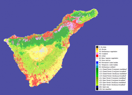
For the CGLS-LS100 main land cover product, it holds 18 classes, see the sample map image for Tenerife above.
| ID | Land Cover Type | EMD Roughness Length | Definition UN LCSS |
|---|---|---|---|
| 0 | No data | z0=NA | NA |
| 20 | Shrubs | z0=0.070 | These are woody perennial plants with persistent and woody stems and without any defined main stem being less than 5 m tall. The shrub foliage can be either evergreen or deciduous. |
| 30 | Herbaceous vegetation | z0=0.500 | Plants without persistent stem or shoots above ground and lacking definite firm structure. Tree and shrub cover is less than 10%. |
| 40 | Cropland | z0=0.100 | Lands covered with temporary crops followed by harvest and a bare soil period (e.g., single and multiple cropping systems). Note that perennial woody crops will be classified as the appropriate forest or shrub land cover type. |
| 50 | Urban / built up | z0=0.400 | Land covered by buildings and other man-made structures. |
| 60 | Bare/sparse vegetation | z0=0.020 | Lands with exposed soil, sand, or rocks and never has more than 10% vegetated cover during any time of the year. |
| 70 | Snow and ice | z0=0.001 | Lands under snow or ice cover throughout the year. |
| 80 | Water bodies - permanent | z0=0.0002 | Lakes, reservoirs, and rivers. Can be either fresh or salt-water bodies. |
| 81 | Water bodies - temporary | z0=0.030 | |
| 90 | Wetland - herbaceous | z0=0.100 | Lands with a permanent mixture of water and herbaceous or woody vegetation. The vegetation can be present in either salt, brackish, or fresh water. |
| 111 | Forest, closed, evergreen needle leaf | z0=0.500 | Tree canopy >70%, almost all needle leaf trees remain green all year. Canopy is never without green foliage. |
| 112 | Forest, closed, evergreen, broad leaf | z0=0.500 | Tree canopy >70%, almost all broadleaf trees remain green year round. Canopy is never without green foliage. |
| 113 | Forest, closed, deciduous, needle leaf | z0=0.500 | Tree canopy >70%, consists of seasonal needle leaf tree communities with an annual cycle of leaf-on and leaf-off periods |
| 114 | Forest, closed, deciduous, broad leaf | z0=0.500 | Tree canopy >70%, consists of seasonal broadleaf tree communities with an annual cycle of leaf-on and leaf-off periods |
| 121 | Forest, open, evergreen, needle leaf | z0=0.400 | Top layer- trees 15-70% and second layer- mixed of shrubs and grassland, almost all needle leaf trees remain green all year. Canopy is never without green foliage. |
| 122 | Forest, open, evergreen, broad leaf | z0=0.400 | Top layer- trees 15-70% and second layer- mixed of shrubs and grassland, almost all broadleaf trees remain green year round. Canopy is never without green foliage. |
| 123 | Forest, open, deciduous, needle leaf | z0=0.400 | Top layer- trees 15-70% and second layer- mixed of shrubs and grassland, consists of seasonal needle leaf tree communities with an annual cycle of leaf-on and leaf-off periods. |
| 124 | Forest, open, deciduous, broad leaf | z0=0.400 | Top layer- trees 15-70% and second layer- mixed of shrubs and grassland, consists of seasonal needle leaf tree communities with an annual cycle of leaf-on and leaf-off periods. |
| 200 | Open Sea | z0=0.000 | Oceans, seas. Can be either fresh or salt-water bodies. |
| 255 | Not classified | z0=NA | NA |
Data License
Data from the Global Land Service is subjected to the free and open access policy from the European Union’s Copernicus Regulation (see here: http://www.copernicus.eu/library/detail/248). Please make sure to use a proper attribution when using these CGLS-LC100 data, such as:
Source: Contains modified Copernicus Service information (2020).
This product was generated by the Global Land Service of Copernicus. It is based on PROBA-V data by ESA and distributed by VITO.
windPRO distribution and adaption by EMD International A/S.
Acknowledgement
- The European Commission and the Copernicus team are acknowledged for the development and release of the free and open Copernicus data.
- Integration of this dataset into EMD services was co-supported through the InnoWind project (www.innowind.dk) which is co-funded by the Danish Innovation Fund
References
- Copernicus Global Land Service, available at: https://land.copernicus.eu
- Copernicus Global Land Operations “Vegetation and Energy” – Product User Manual – Moderate Dynamic Land Cover 100m, Version I2.10, 2019-05-10
- InnoWind project, http://www.innowind.dk

