Search results
Jump to navigation
Jump to search
Page title matches
 (1,325 × 654 (48 KB)) - 10:21, 1 March 2017
 (790 × 506 (34 KB)) - 11:01, 11 January 2024
 (715 × 90 (22 KB)) - 10:58, 8 August 2023
 (1,024 × 309 (39 KB)) - 19:21, 20 February 2017
 (805 × 563 (25 KB)) - 16:31, 14 July 2017
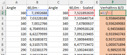 (485 × 209 (17 KB)) - 13:41, 5 January 2016
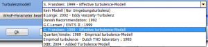 (691 × 156 (17 KB)) - 16:11, 15 August 2016
 (1,178 × 825 (91 KB)) - 17:02, 2 May 2024
 (800 × 650 (70 KB)) - 18:56, 7 January 2016
 (308 × 155 (6 KB)) - 17:59, 11 February 2021
 (606 × 261 (18 KB)) - 12:24, 14 March 2024
 (1,148 × 548 (106 KB)) - 12:45, 20 October 2022
 (550 × 336 (37 KB)) - 12:39, 2 October 2014
 (309 × 44 (3 KB)) - 12:40, 19 May 2016
 (970 × 925 (49 KB)) - 13:52, 4 January 2023
 (1,437 × 982 (392 KB)) - 09:51, 20 April 2023
 (804 × 607 (23 KB)) - 14:44, 11 August 2020
 (501 × 226 (9 KB)) - 19:00, 8 January 2024
 (1,094 × 870 (49 KB)) - 20:08, 2 November 2016
 (921 × 225 (12 KB)) - 15:43, 14 March 2024
.png)
.png)
.png)
.png)
.png)
.png)
.PNG)
.png)
.png)
.png)
.png)
.png)
.png)
.png)
.png)
.png)
.png)
.png)
.png)
.png)
Page text matches
- [[File:DE OPT N(16).png|900px]] ...1 KB (167 words) - 09:57, 20 April 2023
- [[File:DE_MCP2_(16).PNG|700px]] ...1 KB (136 words) - 17:03, 2 May 2024
- [[File:DE_Gelaendeprofil.png|border]] {{Fundort|Menüband '''Geo-Daten''' → [[File:DE_Gelaendeprofil.png|80px|border]]}}; alternativ: {{Fundort|Rechtsklick auf Geometrische-Form-Ob ...4 KB (614 words) - 12:46, 26 February 2024
- * das Fenster {{Fundort|Menü '''Datei''' → [[File:ProjProp.png]]'''[[Projekteigenschaften]]'''}}, in dem einige grundlegende Eigenschaften ...[WEA-Katalog]]''' {{Fundort|Menüband '''Definitionen''' →[[File:WTGCat.png|25px]] [[WEA-Katalog]]}}, der mehr als 1100 WEA-Datensätze enthält und kont ...4 KB (549 words) - 18:04, 21 February 2024
- [[File:WTGArea.png|border|40px]] Das WEA-Flächen-Objekt [[File:WTGArea.png|border]] ist eine Sonderform des [[Areal-Objekt]]s, das zur Definition der ...5 KB (711 words) - 14:33, 10 January 2024
- [[File:Meteo-Analyzer (16).png|600px]] ...5 KB (714 words) - 18:31, 12 December 2023
- * {{Fundort|Menüband '''Geo-Daten''' → [[File:GoogleEarth.png|80px]]}}: Hierbei gelten alle sichtbaren Objekte als vorausgewählt [[File:DE_BASIS_Google-Earth-Integration (16).PNG|350px]] ...5 KB (695 words) - 12:52, 26 February 2024
- [[File:DE_UMWELT_GLARE (16).png|800px]] ...5 KB (652 words) - 14:34, 4 January 2023
- [[File:DE_BASIS_Hoehenraster (16).png|600px]] ...4 KB (596 words) - 14:10, 15 August 2023
- ...nzahl der möglichen Kombinationen 2''n'', d.h. für vier Windfarmen gibt es 16 Legendenkategorien. ...3 KB (448 words) - 11:48, 4 August 2017
- |16||RawCharging||[W]||||43||GreenCurtailLimit||[W] ...5 KB (568 words) - 16:08, 8 August 2023
- |||16||Electricity Price - System Export (tariff)||[EUR] ...8 KB (1,213 words) - 16:05, 8 August 2023
- [[File:DE_BASIS_Layerliste (16).png|400px|border]] ...8 KB (1,031 words) - 17:17, 14 March 2024
- ...nannten Quellen liegen rund 16% niedriger. Außerdem zeigt die Messung etwa 16% mehr Einstrahlung als auf Risø, was auf Basis von Studien vieler weiterer ...10 KB (1,342 words) - 18:50, 21 December 2023
- [[File:DE_Opti(16).png|600px]] ...8 KB (1,005 words) - 13:11, 17 January 2023
- [[File:DE-LAU(1).png|500px]] [[File:DE-LAU(2).png|800px]] ...63 KB (8,539 words) - 15:55, 16 January 2024
- [[File:DE_BASIS_Kostenmodelle(16).png|800px]] ...9 KB (1,172 words) - 12:29, 27 February 2024
- [[File:Scaler_DE(16).png|400px]] ...14 KB (1,846 words) - 12:34, 19 January 2024
- ...eline: Støj fra Vindmøller, Vejledning fra Miljøstyrelsen nr. 1, published 16 May 2012; http://www.mst.dk/Publikationer/Publikationer/2012/Maj/978-87-929 ...9 KB (1,315 words) - 14:06, 3 January 2020
- [[File:DE_BASIS_Projekteigenschaften (16).png|400px]] ...11 KB (1,581 words) - 13:21, 15 August 2023