Search results
Jump to navigation
Jump to search
Page title matches
 (1,325 × 654 (48 KB)) - 10:21, 1 March 2017
 (308 × 155 (6 KB)) - 17:59, 11 February 2021
 (790 × 506 (34 KB)) - 11:01, 11 January 2024
 (715 × 90 (22 KB)) - 10:58, 8 August 2023
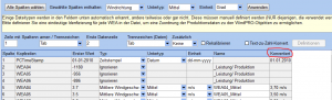 (1,024 × 309 (39 KB)) - 19:21, 20 February 2017
 (805 × 563 (25 KB)) - 16:31, 14 July 2017
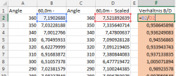 (485 × 209 (17 KB)) - 13:41, 5 January 2016
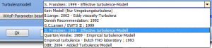 (691 × 156 (17 KB)) - 16:11, 15 August 2016
 (1,178 × 825 (91 KB)) - 17:02, 2 May 2024
 (800 × 650 (70 KB)) - 18:56, 7 January 2016
 (606 × 261 (18 KB)) - 12:24, 14 March 2024
 (1,148 × 548 (106 KB)) - 12:45, 20 October 2022
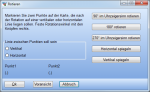 (550 × 336 (37 KB)) - 12:39, 2 October 2014
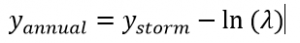 (309 × 44 (3 KB)) - 12:40, 19 May 2016
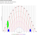 (970 × 925 (49 KB)) - 13:52, 4 January 2023
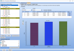 (1,437 × 982 (392 KB)) - 09:51, 20 April 2023
 (804 × 607 (23 KB)) - 14:44, 11 August 2020
 (501 × 226 (9 KB)) - 19:00, 8 January 2024
 (1,094 × 870 (49 KB)) - 20:08, 2 November 2016
 (921 × 225 (12 KB)) - 15:43, 14 March 2024
 (1,080 × 440 (39 KB)) - 10:19, 22 October 2014
 (209 × 24 (3 KB)) - 09:51, 12 August 2015
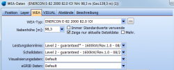 (611 × 247 (29 KB)) - 19:05, 20 April 2015
 (266 × 225 (7 KB)) - 09:46, 2 October 2014
 (490 × 290 (39 KB)) - 12:55, 25 November 2014
 (594 × 435 (19 KB)) - 14:32, 10 January 2024
 (765 × 428 (34 KB)) - 18:10, 10 July 2018
 (643 × 425 (27 KB)) - 09:55, 2 October 2014
 (608 × 441 (42 KB)) - 10:41, 21 October 2014
 (419 × 431 (74 KB)) - 17:00, 20 September 2016
.png)
.png)
.png)
.png)
.png)
.png)
.png)
.PNG)
.png)
.png)
.png)
.png)
.png)
.png)
.png)
.png)
.png)
.png)
.png)
.png)
.png)
.png)
.png)
.png)
.png)
.png)
.PNG)
.png)
.png)
.png)
Page text matches
- [[File:DE OPT N(16).png|900px]] ...1 KB (167 words) - 09:57, 20 April 2023
- [[File:DE_MCP2_(16).PNG|700px]] ...1 KB (136 words) - 17:03, 2 May 2024
- [[File:DE_Gelaendeprofil.png|border]] {{Fundort|Menüband '''Geo-Daten''' → [[File:DE_Gelaendeprofil.png|80px|border]]}}; alternativ: {{Fundort|Rechtsklick auf Geometrische-Form-Ob ...4 KB (614 words) - 12:46, 26 February 2024
- * das Fenster {{Fundort|Menü '''Datei''' → [[File:ProjProp.png]]'''[[Projekteigenschaften]]'''}}, in dem einige grundlegende Eigenschaften ...[WEA-Katalog]]''' {{Fundort|Menüband '''Definitionen''' →[[File:WTGCat.png|25px]] [[WEA-Katalog]]}}, der mehr als 1100 WEA-Datensätze enthält und kont ...4 KB (549 words) - 18:04, 21 February 2024
- [[File:WTGArea.png|border|40px]] Das WEA-Flächen-Objekt [[File:WTGArea.png|border]] ist eine Sonderform des [[Areal-Objekt]]s, das zur Definition der ...5 KB (711 words) - 14:33, 10 January 2024
- [[File:Meteo-Analyzer (16).png|600px]] ...5 KB (714 words) - 18:31, 12 December 2023
- * {{Fundort|Menüband '''Geo-Daten''' → [[File:GoogleEarth.png|80px]]}}: Hierbei gelten alle sichtbaren Objekte als vorausgewählt [[File:DE_BASIS_Google-Earth-Integration (16).PNG|350px]] ...5 KB (695 words) - 12:52, 26 February 2024
- [[File:DE_UMWELT_GLARE (16).png|800px]] ...5 KB (652 words) - 14:34, 4 January 2023
- [[File:DE_BASIS_Hoehenraster (16).png|600px]] ...4 KB (596 words) - 14:10, 15 August 2023
- ...nzahl der möglichen Kombinationen 2''n'', d.h. für vier Windfarmen gibt es 16 Legendenkategorien. ...3 KB (448 words) - 11:48, 4 August 2017
- |16||RawCharging||[W]||||43||GreenCurtailLimit||[W] ...5 KB (568 words) - 16:08, 8 August 2023
- |||16||Electricity Price - System Export (tariff)||[EUR] ...8 KB (1,213 words) - 16:05, 8 August 2023
- [[File:DE_BASIS_Layerliste (16).png|400px|border]] ...8 KB (1,031 words) - 17:17, 14 March 2024
- ...nannten Quellen liegen rund 16% niedriger. Außerdem zeigt die Messung etwa 16% mehr Einstrahlung als auf Risø, was auf Basis von Studien vieler weiterer ...10 KB (1,342 words) - 18:50, 21 December 2023
- [[File:DE_Opti(16).png|600px]] ...8 KB (1,005 words) - 13:11, 17 January 2023
- [[File:DE-LAU(1).png|500px]] [[File:DE-LAU(2).png|800px]] ...63 KB (8,539 words) - 15:55, 16 January 2024
- [[File:DE_BASIS_Kostenmodelle(16).png|800px]] ...9 KB (1,172 words) - 12:29, 27 February 2024
- [[File:Scaler_DE(16).png|400px]] ...14 KB (1,846 words) - 12:34, 19 January 2024
- ...eline: Støj fra Vindmøller, Vejledning fra Miljøstyrelsen nr. 1, published 16 May 2012; http://www.mst.dk/Publikationer/Publikationer/2012/Maj/978-87-929 ...9 KB (1,315 words) - 14:06, 3 January 2020
- [[File:DE_BASIS_Projekteigenschaften (16).png|400px]] ...11 KB (1,581 words) - 13:21, 15 August 2023
- ...en 2700 Wakesituationen berechnet, nämlich für Windgeschwindigkeiten von 2-16 m/s in 1 m/s-Schritten und 2° Richtungsauflösung (180 Sektoren). Dies kann ...15 KB (1,927 words) - 18:33, 19 January 2024
- [[File:DE_PARK(16).png|500px]] ...13 KB (1,727 words) - 15:16, 16 January 2024
- [[File:DE_Lasten_Kap5.6(16).png|210px]] ...18 KB (3,012 words) - 10:43, 17 May 2023
- [[File:DE_HYBRID(16).png|450px]] ...10 KB (1,382 words) - 12:50, 8 August 2023
- [[File:DE_MCP(16).png|600px]] ...13 KB (1,706 words) - 12:48, 15 July 2018
- * Per Telefon Mo-Fr (außer Feiertage) zwischen 09:00 und 16:00 Uhr: '''0561 - 310 59 66''' ...6 KB (836 words) - 15:21, 12 April 2019
- [[File:DE_BASIS_SchallMatAn(16).png|border]] ...25 KB (3,495 words) - 16:43, 24 April 2024
- ...earbeitungsmodus wird durch einen roten Rahmen [[File:BASIS_Linien-Objekt_(16).png]] um das Objekt auf der Karte sowie eine Markierung in der ersten Spal ...12 KB (1,645 words) - 12:14, 26 February 2024
- ...Umlaufbahn der Erde um die Sonne im Laufe eines Jahres insgesamt um bis zu 16 Minuten variieren kann. In Abbildung 12 ist die Abweichung (Zeitkorrektur) ...7 KB (964 words) - 11:37, 4 August 2017
- [[File:DE_solpv(16).png|150px]] ...20 KB (2,784 words) - 15:56, 21 December 2023
- [[File:DE_LASTEN_KAP5.2(16).png|500px|border]] [[File:DE_LASTEN_KAP5.2(17).png|350px|border]] [[File:DE_LASTEN_KAP5.2_Flowres2.PNG|500px|border]] ...28 KB (3,846 words) - 12:25, 20 March 2024
- |Strukturierte Felder (Mixed farmland)||2,0||0,11||0,16||0,098||0,15||0,088 |Stark strukturierte Felder (Closed)||2,5||0,20||0,18||0,109||0,16||0,097 ...29 KB (3,900 words) - 18:28, 19 January 2024
- [[File:DE_PerfC_Datenquelle.PNG|800px]] [[File:DE_PerfC(16).png|700px]] ...28 KB (3,834 words) - 13:11, 12 December 2023
- [[File:WTGCat.png|40px|border]] ...n''', '''Definitionen''', '''Energie''', jeweils ganz rechts: [[File:WTGCat.png|25px|border]]}} ...34 KB (4,785 words) - 09:30, 26 February 2024
- ...f name="SCLR2" /> bestimmt. I<sub>ref</sub> hat die Werte 0,12; 0,14 und 0,16 für die jeweiligen Standard-Turbulenzklassen C, B und A. Bitte beachten Sie [[File:DE_LASTEN_KAP5.2_Wakewidth.PNG|150px|border]] ...32 KB (4,387 words) - 14:28, 20 March 2024
- [[File:DE UMWELT DEC_unc.png]] [[File:DEC_Formeln_1.PNG|180px]] (4) ...42 KB (6,066 words) - 11:21, 11 May 2024
- ...der Karte, zusammengefasst. Das Externe Netz Objekt [[File:ExternalGridObj.png|border]], welches generell das erste Objekt sein sollte, das für den Aufbau [[File:NewWTG.png|border]][[File:ExistWTG.png|border]] ...78 KB (10,453 words) - 12:41, 11 January 2024