MERRA Data

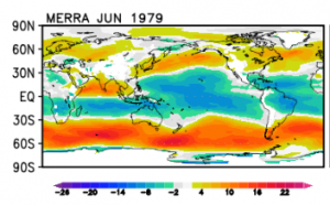
(Credit: Image from NASA)
MERRA is an abbreviation for Modern Era Retrospective-Analysis for Research and Applications. The datasetsoriginates from the Global Modeling and Assimilation Office of NASA / Goddard Space Flight Center.The MERRA analysis are being conducted with the GEOS-5 Atmospheric Data Assimilation System(ADAS).
Resolution and Coverage
The model grid is 0.5 degree latitude and 2/3 degree longitude.
It holds 1 hourly values in a period from 1979 until present.
Coverage is global for land-areas and coastal regions. Offshore coverage is only to be expected up to approximately 50 km from the coast line.
Data Availability
MERRA data is commonly available within WindPRO with a time-tag of 1-2 months. This is due to the processing time of the data at NASA and the subset-processing at EMD. When the data has been processed at EMD, then the following parameters are available from within the online-dataservices WindPRO. Please note that the displacement height is the height at which the log wind profile projects the wind to be zero. See more at the MERRA-FAQ.
| Parameter | Description |
|---|---|
| time | UTC time stamp |
| pressure | Sea level pressure |
| temperature | Temperature at 2 m above the displacement height |
| wDir | Wind direction at 50 m above surface |
| wSpeed | Wind speed at 50 m above surface |
| dispHeight | Displacement height |
Data Experiences
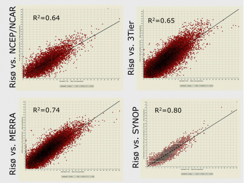
Generally, the MERRA data is always considered when seeking for candidate reference wind datasets for a particular site. Correlateion between local measurements and MERRA data is often high, see the figure below, then the MERRA data was compared against NCEP/NCAR, 3Tier and SYNOP data.

External Links
The full MERRA data-set is available at http://gmao.gsfc.nasa.gov/research/merra/ The MERRA-FAQ is available at: http://gmao.gsfc.nasa.gov/research/merra/faq.php
Acknowledgement
Credits: The Global Modeling and Assimilation Office (GMAO) for the MERRA-analysis and the GES DISC for the dissemination of MERRA.