WindPRO manual test
This page is only for internal testing!!!!!
Introduction, installation & activation
WindPRO introduction, license conditions, service
Introduction
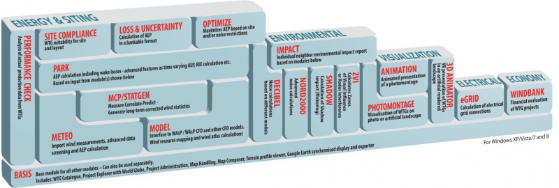
WindPRO is a Windows XP/Vista/7/8 based software suite for the design, development and assessment of wind energy projects. WindPRO consists of a number of modules, each of which has its purpose. The users are free to combine the modules according to their needs and budget. WindPRO is based on more than twenty-five years of experience in the development of user-friendly software tools for wind energy calculations. The experience gained from this, and from the WindPRO team participating in the development of thousands of projects, is applied in the “expert system” WindPRO. The software suite is offered to everyone dealing with project development, planning, sale and approval of wind energy projects.
System demands
Working with bitmap maps requires fast processors and large memory capacity (RAM), which was a challenge for the PC with the first WindPRO version in 1997, but the development of PCs in recent years has solved these problems. A standard Laptop fully fulfill the demands for running WindPRO today, just be aware of the screen resolution should be minimum 1024 x 768 pixels, which might disqualify some of the very small PC’s. See chapter 2.0.2 Recommended hardware and auxiliary software, for further info.
The WindPRO Philosophy: Object Orientated Design/strong graphic interface/On-line data
The WindPRO philosophy is Object Orientated Design. A wind energy project consists of a number of objects among which the turbines (WTGs) are a key element. The program distinguishes between existing and new WTGs and this makes it possible to calculate, for instance, the energy yield or environmental impact from the new WTGs with or without the influence from the existing WTGs.
An object is established on background maps. Any map can be used with the built-in georeference tool or maps from Internet can be downloaded and used with only a few mouse clicks. Similarly, digital elevation models can be established manually with the powerful digitizing tools or simply downloaded from Internet.
Importing, screening and analysis of measured wind data as well as long-term correlation are based on the most comprehensive tools, guiding the user through this very important and complicated task.
