Romania Elevation Model: Difference between revisions
m (→External Links) |
|||
| Line 44: | Line 44: | ||
== External Links == | == External Links == | ||
# The National Agency for Cadastre and Land Registration in Romania (Agenția Națională de Cadastru și Publicitate Imobiliară, ANCPI) - [https://www.ancpi.ro/ HERE] | # The National Agency for Cadastre and Land Registration in Romania (Agenția Națională de Cadastru și Publicitate Imobiliară, ANCPI) - [https://www.ancpi.ro/ HERE] | ||
# Romanian geodata portal (with a lot of nice geodata) - [ | # Romanian geodata portal (with a lot of nice geodata) - [https://geoportal.ancpi.ro/portal/home/ HERE] | ||
Latest revision as of 12:09, 3 July 2024
2024-07-02: This dataset is currently being integrated in windPRO.


Introduction
The National Agency for Cadastre and Land Registration in Romania, known as ANCPI (Agenția Națională de Cadastru și Publicitate Imobiliară), has made available the Romania Elevation Model, a digital terrain model (DTM). The creation of the model was conducted using contour lines with a 1:50,000 scale. The contours derive from the 1995 Romanian Topographic Map, though certain regions have been enhanced with newer information collected through to 2019. The original topographic maps present contour intervals of 10 meters in level terrain and 10-20 meters in hilly areas. So the current Digital Terrain Model (DTM) holds a precision that matches the detail found in the original contours. The initial DTM model is offered at different grid resolutions depending on the area; the most widely accessible are the 5m and 10m resolutions. In windPRO, we provide two versions of the model at 5m and 20m resolutions, both resampled by EMD to ensure the data is suitable for use in broader scopes required for wind farm analysis and wind flow modelling. This resampling is based on the highest resolution data and a bi-linear interpolation method. The data provided by EMD reflects its status as of June 2024.
Dataset Overview
- Spatial Coverage: Romania
- Resolution: 5m and 20 m in windPRO
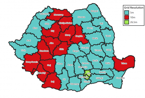
(original data in 5.0m, 10.0m and 26.5m grid resolution either as geotiff or arcgis grid-format, see usage notes below) - Data-type: Digital Terrain Model (DTM)
- Coordinate systems:
- Horizontal: Pulkovo 1942(58) / Stereo70 (EPSG: 3844)
- Version: This dataset reflect the data-status of June 2024.
- Accuracy: (stated by ANCPI)
- 10m for mountainous areas
- 5m for hilly areas
- 1.5m for flat areas
Usage Notes
- The original source data came in different grid-resolutions for regions/counties (Judet) - see the map to the right.
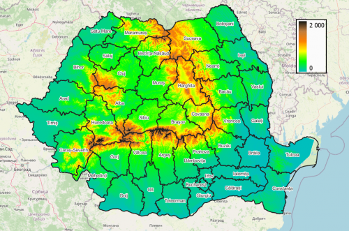
- The original source data does not include part of the Danube delta (to the east in Tulcea and north-east Constanta counties). See the map to the top-right.
- The license conditions (in Romanian language) is available in a pdf - HERE
Availability from within windPRO
The data are available directly from within windPRO as 5m and 20-meter grid resolutions. The data can be accessed from the online-services in the following objects:
- Line Object (with purpose to height contour lines)
- Elevation Grid Object
License
The product belongs to the open geo-data of Romania. The data have been licensed under a national open data policy based on the legal framework: Open Government License - OGL ROU 1.0. EMD recommends the following attribution when using this dataset:
Romania Elevation Model
Source:
 - Data produced by ANCPI (Agenția Națională de Cadastru și Publicitate Imobiliară)
 - www.geoportal.gov.ro
 - This dataset contains public information licensed under the Open Government License v1.0 (OGL ROU 1.0)
Distribution through EMD and windPRO.
Acknowledgement
- The National Agency for Cadastre and Land Registration in Romania (Agenția Națională de Cadastru și Publicitate Imobiliară, ANCPI) and the Romanian public are thanked for producing this digital elevation dataset – and disseminating it in the public domain and thus for aiding the development of renewable energy.