French Raster Map: Difference between revisions
No edit summary |
|||
| (One intermediate revision by one other user not shown) | |||
| Line 1: | Line 1: | ||
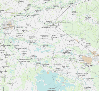
[[Category:Online Data]][[Category:Maps]][[Category: InnoWind]][[File:FranceRasterMap.png|thumb|350px|French Raster Map in scale 1:100000. Source: Contains data from France Raster from the Institut National de l’Information Geographique et Forestiére (IGN) - 2019.]] | [[Category:Online Data]][[Category:Maps]][[Category: InnoWind]][[File:FranceRasterMap.png|thumb|350px|French Raster Map in scale 1:100000. Source: Contains data from France Raster from the Institut National de l’Information Geographique et Forestiére (IGN) - 2019.]] | ||
== Introduction == | == Introduction == | ||
The French Raster Map is a part of the dynamic, zoomable maps in windPRO. The raster maps were released by the Institut National de l’Information Geographique et Forestiére (IGN) as a part of their France Raster dataset. The dynamic map service in windPRO holds this map in scales of 1:100000 | The French Raster Map is a part of the dynamic, zoomable maps in windPRO. The raster maps were released by the Institut National de l’Information Geographique et Forestiére (IGN) as a part of their France Raster dataset. The dynamic map service in windPRO holds this map in various scales of from 1:100000 to 1:8000000. Coverage is the European part of France (Metropolian France). | ||
== Usage Notes == | == Usage Notes == | ||
| Line 17: | Line 17: | ||
== Acknowledgement == | == Acknowledgement == | ||
* The French public and the state of France (with IGN as its representative) are thanked for producing these raster maps and disseminating them with an open-data licence - and thus aiding the development of renewable energy – and wind energy in particular. | * The French public and the state of France (with IGN as its representative) are thanked for producing these raster maps and disseminating them with an open-data licence - and thus aiding the development of renewable energy – and wind energy in particular. | ||
* Integration of this dataset into EMD services | * Integration of this dataset into EMD services was co-supported through the InnoWind project (www.innowind.dk) which is co-funded by the Danish Innovation Fund | ||
== External Links == | == External Links == | ||
* Institut National de l’Information Geographique et Forestiére (IGN): http://professionnels.ign.fr | * Institut National de l’Information Geographique et Forestiére (IGN): http://professionnels.ign.fr | ||
Latest revision as of 10:54, 17 January 2020

Introduction
The French Raster Map is a part of the dynamic, zoomable maps in windPRO. The raster maps were released by the Institut National de l’Information Geographique et Forestiére (IGN) as a part of their France Raster dataset. The dynamic map service in windPRO holds this map in various scales of from 1:100000 to 1:8000000. Coverage is the European part of France (Metropolian France).
Usage Notes
- The map was derived from source data accessed in May-June 2019.
Availability from Within windPRO
- From map window: Click the ‘Add map’ globe-icon -> then ‘Dynamic Maps’
- From main menu: Click ‘Project’ -> ‘Properties’ -> ‘Background Maps’ -> ‘Dynamic Maps’
License and Attribution
This map is created based on sources that belongs to the open data of the IGN of France. Open data by IGN is licensed under the French License Ouverte / Open License – a license used for open data from the State of France. The license is designed to be compatible to be compatible with Creative Commons Licenses, Open Government License (UK) and the Open Data Commons Attribution License read pdf here. It is required that the source of information is mentioned when using these data, so please use the following attribution when using this dataset in reports or publications:
Data Source: Contains data from France Raster from the Institut National de l’Information Geographique et Forestiére (IGN) - 2019. Data-processing and distribution by EMD and windPRO.
Acknowledgement
- The French public and the state of France (with IGN as its representative) are thanked for producing these raster maps and disseminating them with an open-data licence - and thus aiding the development of renewable energy – and wind energy in particular.
- Integration of this dataset into EMD services was co-supported through the InnoWind project (www.innowind.dk) which is co-funded by the Danish Innovation Fund
External Links
- Institut National de l’Information Geographique et Forestiére (IGN): http://professionnels.ign.fr