Latvian Elevation Model: Difference between revisions
(Created page with "This page will hold description on the Latvian Elevation model.") |
|||
| (19 intermediate revisions by 2 users not shown) | |||
| Line 1: | Line 1: | ||
[[Category: Online Data]][[Category: Digital Elevation Models]][[Category: InnoWind]] | |||
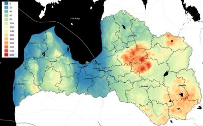
[[Image:LatviaDTM_Coverage.png|right|thumb|400px|Coverage of Latvian DTM. Credits: Elevation data: Geospatial Information Agency of Latvia 05/2019]] | |||
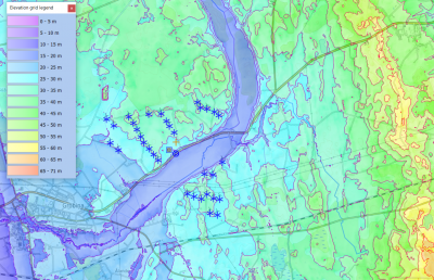
[[Image:WindFarm_Grobina_Latvia_2019.png|right|thumb|400px|Latvian DTM at Wind Farm at Grobina, Latvia]] | |||
== Introduction == | |||
The Latvian elevation model in 20m grid resolution is a digital terrain model produced by the Geospatial Information Agency of Latvia (Latvijas Ģeotelpiskās Informācijas Aģentūras). The model was derived from LiDAR scans and stereo-orthophotos. Spatial coverage is for the whole of Latvia. The data available in windPRO was accessed during early 2019 – and holds data with source-date 2017. | |||
=== Dataset Overview === | |||
* '''Spatial Coverage:''' Lativa | |||
* '''Resolution:''' 20 m | |||
* '''Data-type:''' [[:Category%3ADigital_Elevation_Models#What_type_of_elevation_model.3F_DEM.2C_DSM_and_DTM.3F|Digital Terrain Model (DTM)]] | |||
* '''Coordinate system:''' Raw data was delivered as ERSI gridded files – with coordinate-system data embedded (Transverse Mercator with central median 24 degree longitude). | |||
* '''Version:''' Source data is from 2017. | |||
* '''Vertical Accuracy:''' N/A | |||
== Availability from within windPRO == | |||
The data are available directly from within windPRO in 20-meter resolution. The data can be accessed from the online-services in the following objects: | |||
* Line Object (with purpose to height contour lines) | |||
* Elevation Grid Object | |||
== License and Attribution == | |||
The product belongs to the open data of the Geospatial Information Agency of Latvia. The data have no specific open-data license attached – however these are released with the following open-data principles: free, online, machine-readable-formats. Read more about the policy here: “[https://opendata.lgia.gov.lv/ Publiskās pārvaldes datu pieejamība atvērtā veidā ir viens no e-pārvaldes politikas pamatprincipiem 2014–2020 gada attīstības plānošanas periodā]”. | |||
Link to pdf’s printed from the Latvian web-page and unofficial English translation of the conditions are available from these links <[http://help.emd.dk/mediawiki/images/6/64/PDF-LV.pdf in latvian]> and <[http://help.emd.dk/mediawiki/images/9/9c/PDF-UK.pdf in english]>. | |||
<pre> | |||
Contains elevation data from the Geospatial Information Agency of Latvia 05/2019. | |||
Distribution through EMD and windPRO. | |||
</pre> | |||
== Acknowledgements == | |||
* The Geospatial Information Agency of Latvia and the pubic of Latvia are thanked for producing this digital elevation dataset – and disseminating it in the public domain - and thus for aiding the development of renewable energy. | |||
* Integration of this dataset into EMD services was co-supported through the InnoWind project ([http://www.innowind.dk www.innowind.dk) which is co-funded by the Danish Innovation Fund | |||
== External Links == | |||
* Geospatial Information Agency of Latvia: https://map.lgia.gov.lv | |||
* InnoWind project: http://www.innowind.dk | |||
Latest revision as of 10:49, 24 June 2020


Introduction
The Latvian elevation model in 20m grid resolution is a digital terrain model produced by the Geospatial Information Agency of Latvia (Latvijas Ģeotelpiskās Informācijas Aģentūras). The model was derived from LiDAR scans and stereo-orthophotos. Spatial coverage is for the whole of Latvia. The data available in windPRO was accessed during early 2019 – and holds data with source-date 2017.
Dataset Overview
- Spatial Coverage: Lativa
- Resolution: 20 m
- Data-type: Digital Terrain Model (DTM)
- Coordinate system: Raw data was delivered as ERSI gridded files – with coordinate-system data embedded (Transverse Mercator with central median 24 degree longitude).
- Version: Source data is from 2017.
- Vertical Accuracy: N/A
Availability from within windPRO
The data are available directly from within windPRO in 20-meter resolution. The data can be accessed from the online-services in the following objects:
- Line Object (with purpose to height contour lines)
- Elevation Grid Object
License and Attribution
The product belongs to the open data of the Geospatial Information Agency of Latvia. The data have no specific open-data license attached – however these are released with the following open-data principles: free, online, machine-readable-formats. Read more about the policy here: “Publiskās pārvaldes datu pieejamība atvērtā veidā ir viens no e-pārvaldes politikas pamatprincipiem 2014–2020 gada attīstības plānošanas periodā”.
Link to pdf’s printed from the Latvian web-page and unofficial English translation of the conditions are available from these links <in latvian> and <in english>.
Contains elevation data from the Geospatial Information Agency of Latvia 05/2019.
Distribution through EMD and windPRO.
Acknowledgements
- The Geospatial Information Agency of Latvia and the pubic of Latvia are thanked for producing this digital elevation dataset – and disseminating it in the public domain - and thus for aiding the development of renewable energy.
- Integration of this dataset into EMD services was co-supported through the InnoWind project ([http://www.innowind.dk www.innowind.dk) which is co-funded by the Danish Innovation Fund
External Links
- Geospatial Information Agency of Latvia: https://map.lgia.gov.lv
- InnoWind project: http://www.innowind.dk