Poland Elevation Model: Difference between revisions
m (→Usage Notes) |
mNo edit summary |
||
| (13 intermediate revisions by 2 users not shown) | |||
| Line 1: | Line 1: | ||
[[Category: Online Data]][[Category: Digital Elevation Models]] | [[Category: Online Data]][[Category: Digital Elevation Models]] | ||
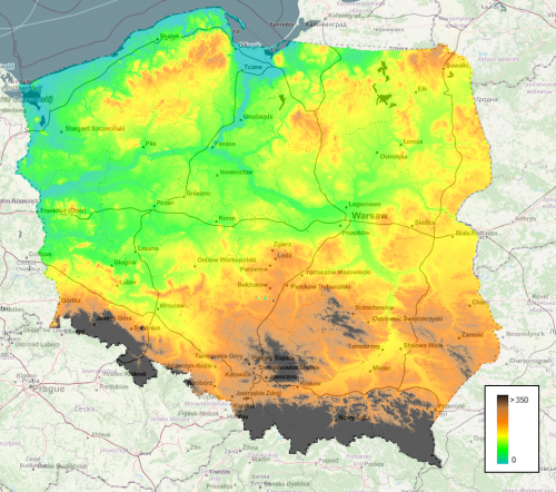
[[File:20230721_PolishElevationModel.png|right|thumb| | [[File:20230721_PolishElevationModel.png|right|thumb|500px|Seamless Mosaic of the Poland DTM (elevations in meters).]] | ||
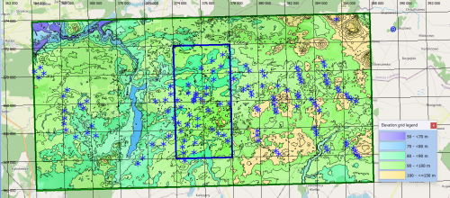
[[File:PolishElevationModel_CityOfMargonin.png|right|thumb|500px|Polish Elevation Model in windPRO: 5m and 20m gridded data - near town of Margonin.]] | |||
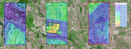
[[File:PolishElevationModel_CityOfInowroclaw.png|right|thumb|500px|Polish DTM's in 3 resolutions - near the city of Inowroclaw.]] | |||
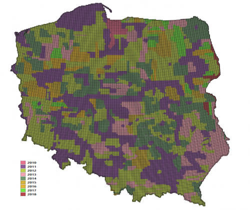
[[File:PolandDGM_Coverage.png|right|thumb|500px|Coverage of the Poland DTM - here shown as polygons for the about 65000 tiles each 2.2km x 2.35km forming the DTM. The color of the individual tile indicates the year of the campaign, see the legend. Some areas are covered by multiple campaigns (years).]] | |||
== Introduction == | == Introduction == | ||
The Poland Elevation Model is a digital terrain model released from the Head Office of Geodesy and Cartography (Główny Urząd Geodezji i Kartografii, GUGiK), Poland. The dataset is an accurate digital terrain model (DTM) developed as a part of a multi-year data-collection process - with the DTM in windPRO holding data from primarily years 2010-2018. The dataset is mainly made from airborne laser-scans and stereoscopic measurements. The original data is mainly stored as a 1m grid - and in approximately 64000 individual tiles - each sized 2.2km x 2.35km. Three Polish elevation models are delivered as seamless mosaics with windPRO: at 1m, 5m and 20m grid resolutions. The original model is available at resolution of 1.0m, however, the coarser resolution models (5m, 20m) in windPRO are resampled by EMD. This is done in order for the data to be operational for the larger domains needed in the context of wind farm analysis and wind flow modelling. The resampling is made based on 1m data using a bi-linear interpolation algorithm. Data made available by EMD represents the data status of December 2021 and July 2023. | The Poland Elevation Model is a digital terrain model released from the Head Office of Geodesy and Cartography (Główny Urząd Geodezji i Kartografii, GUGiK), Poland. The dataset is an accurate digital terrain model (DTM) developed as a part of a multi-year data-collection process - with the DTM in windPRO holding data from primarily years 2010-2018. The dataset is mainly made from airborne laser-scans and stereoscopic measurements. The original data is mainly stored as a 1m grid - and in approximately 64000 individual tiles - each sized 2.2km x 2.35km. Three Polish elevation models are delivered as seamless mosaics with windPRO: at 1m, 5m and 20m grid resolutions. The original model is available at resolution of 1.0m, however, the coarser resolution models (5m, 20m) in windPRO are resampled by EMD. This is done in order for the data to be operational for the larger domains needed in the context of wind farm analysis and wind flow modelling. The resampling is made based on 1m data using a bi-linear interpolation algorithm. Data made available by EMD represents the data status of December 2021 and July 2023. | ||
| Line 17: | Line 19: | ||
== Usage Notes == | == Usage Notes == | ||
* A few - about 20 - tiles in a narrow strip approximately 1.5 km from the eastern boarder did not hold data at the 1m grid resolution. These (few) tiles have not been included in this model. | * '''Please be patient when downloading data from this model''' - it may take some '''minutes''' for our servers to compile the data for you (especially for the 1m and 5m models). This is due to the high-resolution and size of the model - with about 1.4Tb of elevation data records in 64000 indivudual data-tiles. If this is an issue for you, please consider to use smaller areas with high-resolution data (1m, 5m)- and larger areas with 20m resolution data. | ||
* Since the data-source contains campaigns from multiple years, generally, data from the most recent year has been used in windPRO. In the case of issues/ | * A few - about 20 - tiles in a narrow strip approximately 1.5 km from the eastern boarder did not hold data at the 1m grid resolution. These (few) tiles have not been included in this mosaic model from EMD. | ||
* Since the data-source contains campaigns from multiple years, generally, data from the most recent year has been used in windPRO. In the case of issues/problems with the most recent data-source, it was replaced with older data. | |||
* Due to missing data, five 2x2km tiles to the north of the city of Szczytno was taken from the PL-EVRF2007-NH model. These tiles had their vertical reference changed to match that of this DTM-mosaic (vertical correction was in the order of 0.3m). | * Due to missing data, five 2x2km tiles to the north of the city of Szczytno was taken from the PL-EVRF2007-NH model. These tiles had their vertical reference changed to match that of this DTM-mosaic (vertical correction was in the order of 0.3m). | ||
*If you find issues/problems/missing-data within this dataset, feel free to contact our data custodian - Morten Lybech Thøgersen (mlt@emd.dk), with the | *If you find issues/problems/missing-data within this dataset, feel free to contact our data custodian - Morten Lybech Thøgersen (mlt@emd.dk), with the nature of the issue and the location (geographical coordinates). | ||
== Availability from within | == Availability from within windPRO == | ||
The data are available directly from within windPRO in 1m, 5m and 20-meter grid resolutions. The data can be accessed from the online-services in the following objects: | The data are available directly from within windPRO in 1m, 5m and 20-meter grid resolutions. The data can be accessed from the online-services in the following objects: | ||
* Line Object (with purpose to height contour lines) | * Line Object (with purpose to height contour lines) | ||
Latest revision as of 15:22, 21 July 2023


Introduction
The Poland Elevation Model is a digital terrain model released from the Head Office of Geodesy and Cartography (Główny Urząd Geodezji i Kartografii, GUGiK), Poland. The dataset is an accurate digital terrain model (DTM) developed as a part of a multi-year data-collection process - with the DTM in windPRO holding data from primarily years 2010-2018. The dataset is mainly made from airborne laser-scans and stereoscopic measurements. The original data is mainly stored as a 1m grid - and in approximately 64000 individual tiles - each sized 2.2km x 2.35km. Three Polish elevation models are delivered as seamless mosaics with windPRO: at 1m, 5m and 20m grid resolutions. The original model is available at resolution of 1.0m, however, the coarser resolution models (5m, 20m) in windPRO are resampled by EMD. This is done in order for the data to be operational for the larger domains needed in the context of wind farm analysis and wind flow modelling. The resampling is made based on 1m data using a bi-linear interpolation algorithm. Data made available by EMD represents the data status of December 2021 and July 2023.
Dataset Overview
- Spatial Coverage: Poland
- Resolution: 1m, 5m and 20 m in windPRO (original data in 1.0m grid resolution as asc-format and xyz-format)
- Data-type: Digital Terrain Model (DTM)
- Coordinate systems:
- Horizontal: Poland CS92 / ETRS89 - EPSG:2180
- Vertical: PL-KRON86-NH
- Version: Main parts of the data were downloaded in December 2021. A few tiles where downloaded in June 2023.
- Accuracy:
- The accuracy depends on the data-source and is not explicitly stated. However, typical accuracies are less than 0.3-0.5m for LiDAR data and less than 1.0m-3.0m for stereo-correlation data.
Usage Notes
- Please be patient when downloading data from this model - it may take some minutes for our servers to compile the data for you (especially for the 1m and 5m models). This is due to the high-resolution and size of the model - with about 1.4Tb of elevation data records in 64000 indivudual data-tiles. If this is an issue for you, please consider to use smaller areas with high-resolution data (1m, 5m)- and larger areas with 20m resolution data.
- A few - about 20 - tiles in a narrow strip approximately 1.5 km from the eastern boarder did not hold data at the 1m grid resolution. These (few) tiles have not been included in this mosaic model from EMD.
- Since the data-source contains campaigns from multiple years, generally, data from the most recent year has been used in windPRO. In the case of issues/problems with the most recent data-source, it was replaced with older data.
- Due to missing data, five 2x2km tiles to the north of the city of Szczytno was taken from the PL-EVRF2007-NH model. These tiles had their vertical reference changed to match that of this DTM-mosaic (vertical correction was in the order of 0.3m).
- If you find issues/problems/missing-data within this dataset, feel free to contact our data custodian - Morten Lybech Thøgersen (mlt@emd.dk), with the nature of the issue and the location (geographical coordinates).
Availability from within windPRO
The data are available directly from within windPRO in 1m, 5m and 20-meter grid resolutions. The data can be accessed from the online-services in the following objects:
- Line Object (with purpose to height contour lines)
- Elevation Grid Object
License
The product belongs to the open geo-data of Poland. The data have been licensed under a national open data policy based on the following legal framework:
- Prawo geodezyjne ikartograficzne (Polish geodetic and cartographic law, article 40a)
- Usage-conditions (web-link, accessed 2021-10-12) - HERE
EMD recommends the following attribution when using this dataset:
Polish Elevation Model.
Source:
 - Head Office of Geodesy and Cartography (GUGiK).
 - https://www.geoportal.gov.pl/dane/numeryczny-model-pokrycia-terenu
Distribution through EMD and windPRO.
Acknowledgement
- The Head Office of Geodesy and Cartography (Główny Urząd Geodezji i Kartografii, GUGiK) and the Polish public are thanked for producing this digital elevation dataset – and disseminating it in the public domain and thus for aiding the development of renewable energy.