German Baden-Württemberg Elevation Models: Difference between revisions
(Created page with "Category: Online DataCategory: Digital Elevation Models right|thumb|350px|Coverage of the DTM (DGM). right|thumb|350px|Baden-Württemberg Elevation Model (DGM) == Introduction == The digital elevation model for the German state of Baden-Württemberg is derived from open geodata specific to this region. The model is provided by the Landesamt für Geoinformation und Landentwicklun...") |
mNo edit summary |
||
| (13 intermediate revisions by the same user not shown) | |||
| Line 1: | Line 1: | ||
[[Category: Online Data]][[Category: Digital Elevation Models]] | [[Category: Online Data]][[Category: Digital Elevation Models]] | ||
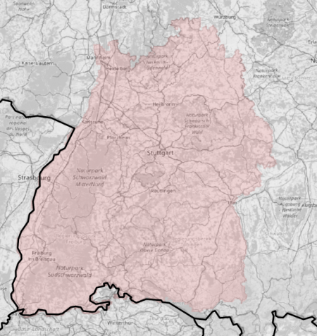
[[File:BadenWurttemberg-Coverage- | [[File:BadenWurttemberg-Coverage-Map2.png|right|thumb|450px|Coverage of the DTM (DGM).]] | ||
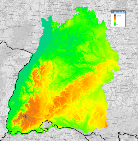
[[Image:Germany-BadenWurttemberg-DGM.png|right|thumb| | [[Image:Germany-BadenWurttemberg-DGM.png|right|thumb|450px|Baden-Württemberg Elevation Model (DGM)]] | ||
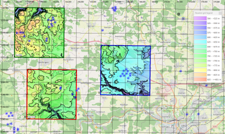
[[Image:20240729_BW.png|right|thumb|450px|1m, 5m and 20m DGM's in windPRO (near Ulm, Baden-Württemberg)]] | |||
== Introduction == | == Introduction == | ||
The digital elevation model for the German state of Baden-Württemberg is derived from open geodata specific to this region. The model is provided by the Landesamt für Geoinformation und Landentwicklung (LGL). Three versions of the elevation model are included with windPRO, each with different grid resolutions: 1m, 5m, and 20m. While the original model offers a maximum resolution of 1m, the two other models in windPRO are resampled by EMD to slightly coarser resolutions of 5m and 20m. This resampling is performed to ensure the data is better suitable for larger domains, which are typically required for wind farm analyses and wind flow modelling. The 1m grid resolution data is specifically | The digital elevation model for the German state of Baden-Württemberg is derived from open geodata specific to this region. The original model in 1m grid-resolution is provided by the Landesamt für Geoinformation und Landentwicklung (LGL). Three versions of the elevation model are included with windPRO, each with different grid resolutions: 1m, 5m, and 20m. While the original model offers a maximum resolution of 1m, the two other models in windPRO are resampled by EMD to slightly coarser resolutions of 5m and 20m. This resampling is performed to ensure the data is better suitable for larger domains, which are typically required for wind farm analyses and wind flow modelling. The 1m grid resolution data is specifically included with windPRO with the intension to be used for photomontage modelling. Please note that the data provided by EMD reflects the status as of June 2024. The Baden-Württemberg elevation model in windPRO is based on aerial lidar-scans from years 2016-2021. | ||
=== Dataset Overview === | === Dataset Overview === | ||
* '''Spatial Coverage:''' Bundesland of Baden-Württemberg | * '''Spatial Coverage:''' Bundesland of Baden-Württemberg | ||
| Line 11: | Line 12: | ||
** ''Horizontal:'' ETRS89/UTM32 (EPSG 25832) | ** ''Horizontal:'' ETRS89/UTM32 (EPSG 25832) | ||
** ''Vertical:'' DHHN2016 | ** ''Vertical:'' DHHN2016 | ||
* '''Version:''' Data were downloaded in June 2024 | * '''Version:''' Data were downloaded in June 2024. | ||
* '''Accuracy:''' | * '''Accuracy:''' | ||
** ''Vertical:'' For the 1m resolution dataset the vertical accuracy is stated to be ±0.15m. | ** ''Vertical:'' For the 1m resolution dataset the vertical accuracy is stated to be ±0.15m. | ||
** ''Horizontal:'' N/A | ** ''Horizontal:'' N/A | ||
* '''No-data value''': | * '''No-data value''': 0 in original data / -9999 in windPRO datasets | ||
== Usage Notes == | == Usage Notes == | ||
| Line 22: | Line 23: | ||
== License and Attribution == | == License and Attribution == | ||
The data is based on open geo-data of Baden-Württemberg, released under a open-data policy | The data is based on open geo-data of Baden-Württemberg, released under a open-data policy. When using the dataset, the please acknowledge the origin of the data, such as: <br> | ||
<pre> | <pre> | ||
Source/Datenquelle: LGL, www.lgl-bw.de | Source/Datenquelle: LGL, www.lgl-bw.de | ||
| Line 36: | Line 37: | ||
* Information on open geodata in Baden-Württemberg - [https://opengeodata.lgl-bw.de HERE] | * Information on open geodata in Baden-Württemberg - [https://opengeodata.lgl-bw.de HERE] | ||
* Landesamt für Geoinformation und Landentwicklung (LGL), Baden-Württemberg - [https://www.lgl-bw.de/ HERE] | * Landesamt für Geoinformation und Landentwicklung (LGL), Baden-Württemberg - [https://www.lgl-bw.de/ HERE] | ||
Latest revision as of 09:03, 31 July 2024


Introduction
The digital elevation model for the German state of Baden-Württemberg is derived from open geodata specific to this region. The original model in 1m grid-resolution is provided by the Landesamt für Geoinformation und Landentwicklung (LGL). Three versions of the elevation model are included with windPRO, each with different grid resolutions: 1m, 5m, and 20m. While the original model offers a maximum resolution of 1m, the two other models in windPRO are resampled by EMD to slightly coarser resolutions of 5m and 20m. This resampling is performed to ensure the data is better suitable for larger domains, which are typically required for wind farm analyses and wind flow modelling. The 1m grid resolution data is specifically included with windPRO with the intension to be used for photomontage modelling. Please note that the data provided by EMD reflects the status as of June 2024. The Baden-Württemberg elevation model in windPRO is based on aerial lidar-scans from years 2016-2021.
Dataset Overview
- Spatial Coverage: Bundesland of Baden-Württemberg
- Resolution: 1m, 5m and 20m (in windPRO)
- Data-type: Digital Terrain Model (DTM)
- Coordinate system
- Horizontal: ETRS89/UTM32 (EPSG 25832)
- Vertical: DHHN2016
- Version: Data were downloaded in June 2024.
- Accuracy:
- Vertical: For the 1m resolution dataset the vertical accuracy is stated to be ±0.15m.
- Horizontal: N/A
- No-data value: 0 in original data / -9999 in windPRO datasets
Usage Notes
- Please be aware that the download and processing time for the high-resolution datasets (1m and 5m grid) can take several minutes. This is due to the large volume of high-resolution elevation data and the tile-based storage system, which contains about 40,000 individual data-tiles. As such, downloading data for a specific site may take some time. If this poses an issue, consider downloading data for smaller areas or opting for the coarser 20m resolution data.
- For the 1-meter grid, the downloadable area is restricted to a 5 km x 5 km region to maintain manageable file sizes. For the 5-meter grid, the downloadable area is limited to a 20 km x 20 km region. If necessary, the data within the elevation object can be supplemented with coarser data to cover a larger area. Please plan your downloads accordingly.
License and Attribution
The data is based on open geo-data of Baden-Württemberg, released under a open-data policy. When using the dataset, the please acknowledge the origin of the data, such as:
Source/Datenquelle: LGL, www.lgl-bw.de
License: Datenlizenz Deutschland – Namensnennung – Version 2.0 (dl-de/by-2-0) - www.govdata.de/dl-de/by-2-0
Distribution: EMD/windPRO elevation model based on data from Landesamt für Geoinformation und Landentwicklung (LGL), Baden-Württemberg.
Acknowledgement
- The LGL are thanked for producing this digital elevation dataset – and disseminating it in the public domain and thus for aiding the development of renewable energy and wind energy in particular.