Canadian Elevation Models: Difference between revisions
m (→Usage Notes) |
|||
| (43 intermediate revisions by the same user not shown) | |||
| Line 1: | Line 1: | ||
[[Category: Online Data]][[Category: Digital Elevation Models]] | [[Category: Online Data]][[Category: Digital Elevation Models]] | ||
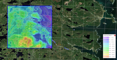
[[Image:canada_elevation_model_20m.png|right|thumb|450px|Canadian DEM ( | [[Image:20240809_Newfoundland.png|right|thumb|450px|MRDEM Canadian DEM: At work at Fermeuse Wind Farm, 60km south of St. John's, Newfoundland.]] | ||
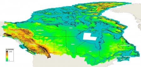
[[Image:canada_elevation_model_resolution.png|right|thumb|450px|Canadian DEM ( | [[Image:canada_mrdem_elevation_model_30m.png|right|thumb|450px|MRDEM Canadian DEM: Coverage.]] | ||
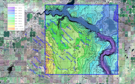
[[Image:Canada_BlackSpringRidge.png|right|thumb|450px|Canadian CDEM. At work at Black Spring Ridge Wind Farm, Vulcan County, Alberta, Canada.]] | |||
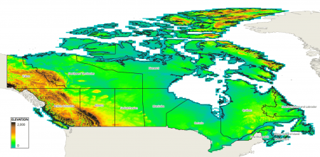
[[Image:canada_elevation_model_20m.png|right|thumb|450px|CDEM Canadian DEM (Legacy): Coverage.]] | |||
[[Image:canada_elevation_model_resolution.png|right|thumb|450px|CDEM Canadian DEM (Legacy) - data-tiles with their resolution.]] | |||
== Introduction == | == Introduction == | ||
The Canadian elevation | The Canadian elevation models are digital elevation models (DEM’s) produced by Natural Resources Canada, NRCan. Currently, two Canadian DEM models are available from windPRO: | ||
'''1. Canada MRDEM-DTM Elevation Model - 30m resolution - (MRDEM)'''<br> | |||
The Canadian Medium Resolution Digital Elevation Model (MRDEM-DTM), part of the CanElevation Series developed by Natural Resources Canada (NRCan), offers a native spatial resolution of 30 meters. This dataset is a mosaic derived from two primary sources: the [[Copernicus_DEM|CopernicusDEM]] (TandemX mission) and the national high-resolution HRDEM (Airborne LiDAR) model. The elevation values in this DTM dataset represent the bare ground surface, excluding objects such as vegetation and man-made structures. For use in this model, NRCan resampled the HRDEM 1-meter data into a 30-meter grid resolution. In windPRO, we deliver the data in 0.75 arc-second resolution (approx. 25m). The data have been resampled by EMD using a bi-linear algorithm. | |||
=== Dataset Overview === | '''2. Canada CDEM Elevation Model - 0.75 arc-second [LEGACY] - (CDEM)'''<br> | ||
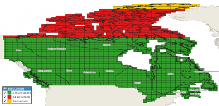
The Canadian elevation model in its 0.75-arc-second resolution is a digital elevation model (DEM’s) produced by Natural Resources Canada (NRCan). CDEM is mainly based on elevation contours and hydrographic data from NRCan's Geospatial Data Base at the scale of 1:50,000, or at other scales provided by other provinces and territories. Temporal coverage is 1945-2011. The source dataset holds different resolutions from 0.75-arc-second (below N69) to 3-arc-second (above N81). For consistency, windPRO always delivers the data with a 0.75 arc-second resolution - with the coarser tiles being resampled with a bi-linear algorithm. | |||
Please consult the product-specifications (see links below) for more details. | |||
=== Dataset Overview - MRDEM === | |||
* '''Spatial Coverage:''' Canada | |||
* '''Resolution:''' | |||
** In windPRO: 0.75 arc-second (approximately 25m) | |||
** Source data: 30 meters | |||
* '''Data-type:''' [[:Category%3ADigital_Elevation_Models#What_type_of_elevation_model.3F_DEM.2C_DSM_and_DTM.3F|Digital Terrain Model (DTM)]] | |||
* '''Coordinate system:''' | |||
** Horizontal (windPRO): Geographic WGS - NAD83 (EPSG:4617) | |||
** Horizontal (source): Canada Atlas Lambert NAD83 (CSRS) (EPSG:3979) | |||
** Vertical: CGVD2013 | |||
* '''Version:''' This is version 1.0 of MRDEM (released 2024-02.28). EMD procured this dataset in august 2024. | |||
* '''Vertical Accuracy:''' N/A | |||
=== Dataset Overview - CDEM === | |||
* '''Spatial Coverage:''' Canada | * '''Spatial Coverage:''' Canada | ||
* '''Resolution:''' | * '''Resolution:''' | ||
** | ** windPRO: 0.75 arc-second (approximately 25m) | ||
** Source | ** Source: 0.75 arc-second resolution below N69, 3-arc-seconds north of N81, other areas are typically 1.4 arc-second resolution (see image to the right). | ||
* '''Data-type:''' [[:Category%3ADigital_Elevation_Models#What_type_of_elevation_model.3F_DEM.2C_DSM_and_DTM.3F|Digital Elevation Model (DEM)]] | * '''Data-type:''' [[:Category%3ADigital_Elevation_Models#What_type_of_elevation_model.3F_DEM.2C_DSM_and_DTM.3F|Digital Elevation Model (DEM)]] | ||
* '''Coordinate system:''' | * '''Coordinate system:''' | ||
| Line 21: | Line 42: | ||
== Usage Notes == | == Usage Notes == | ||
* | * If you need even higher-resolution data (down to 1m or 2m grid resolution from LiDAR and optical sources), then NRCan also offers a High Resolution Digital Elevation Model (HRDEM) for selected regions and territories - see [https://open.canada.ca/data/dataset/957782bf-847c-4644-a757-e383c0057995 HERE]. Complete coverage of the Canadian territory is gradually being established (2024). | ||
* CDEM is a legacy DEM product that is no longer supported by the Natural Resources Canada as it may not meet current government standards. EMD recommends using MRDEM. | |||
== Availability from within WindPRO == | == Availability from within WindPRO == | ||
The data are available directly from within windPRO in | The data are available directly from within windPRO in 0.75-arc-second (~25-meter, CDEM) resolution or 30m resolution (MRDEM). The data can be accessed from the online-services in the following objects: | ||
* Line Object (with purpose to height contour lines) | * Line Object (with purpose to height contour lines) | ||
* Elevation Grid Object | * Elevation Grid Object | ||
== License and Attribution == | == License and Attribution == | ||
These products belong to the open data of Natural Resources Canada (NRCan). The data have been licensed under an ‘Open Government Licence – Canada (version 2.0)' - see [https://help.emd.dk/mediawiki/images/8/8a/CDEM_license.pdf here]. Please accept the license conditions and use a proper attribution when using these dataset, such as: | |||
<pre> | <pre> | ||
MRDEM: Canadian Medium Resolution Digital Elevation Model (MRDEM-DTM), | |||
This product was in part produced using Copernicus WorldDEM-30. | |||
© DLR e.V. 2010-2014 and © Airbus Defence and Space GmbH 2014- 2018 provided under COPERNICUS by the European Union and ESA; | |||
All rights reserved. | |||
CDEM: Canada digital elevation model (DEM) data from Natural Resources Canada (NRCan). | |||
License: Open Government Licence – Canada. | License: Open Government Licence – Canada. | ||
Source: Distribution through EMD and windPRO. | Source: Distribution through EMD and windPRO. | ||
| Line 37: | Line 63: | ||
== Acknowledgement == | == Acknowledgement == | ||
* Natural Resources Canada (NRCan) and the public of Canada are thanked for producing | * Natural Resources Canada (NRCan) and the public of Canada are thanked for producing these digital elevation datasets – and disseminating these in the public domain - and thus for aiding the development of renewable energy. | ||
== External Links == | == External Links == | ||
* Government of Canada - Geospatial Data Extraction Tool - [https://maps.canada.ca/czs/index-en.html HERE] | * Government of Canada - Geospatial Data Extraction Tool - [https://maps.canada.ca/czs/index-en.html HERE] | ||
* MRDEM - product specification (pdf-file) - [https://help.emd.dk/mediawiki/images/1/14/MRDEM-Product-Specifications.pdf HERE] | |||
* CDEM - information sheet (pdf-file) - [https://help.emd.dk/mediawiki/images/3/33/CDEM_information_sheet.pdf HERE] | * CDEM - information sheet (pdf-file) - [https://help.emd.dk/mediawiki/images/3/33/CDEM_information_sheet.pdf HERE] | ||
* CDEM - product specification (pdf-file) - [https://help.emd.dk/mediawiki/images/f/fa/CDEM_product_specification.pdf HERE] | * CDEM - product specification (pdf-file) - [https://help.emd.dk/mediawiki/images/f/fa/CDEM_product_specification.pdf HERE] | ||
* HRDEM - product description - [https://open.canada.ca/data/dataset/957782bf-847c-4644-a757-e383c0057995 HERE] | |||
Latest revision as of 08:39, 9 August 2024
Introduction
The Canadian elevation models are digital elevation models (DEM’s) produced by Natural Resources Canada, NRCan. Currently, two Canadian DEM models are available from windPRO:
1. Canada MRDEM-DTM Elevation Model - 30m resolution - (MRDEM)
The Canadian Medium Resolution Digital Elevation Model (MRDEM-DTM), part of the CanElevation Series developed by Natural Resources Canada (NRCan), offers a native spatial resolution of 30 meters. This dataset is a mosaic derived from two primary sources: the CopernicusDEM (TandemX mission) and the national high-resolution HRDEM (Airborne LiDAR) model. The elevation values in this DTM dataset represent the bare ground surface, excluding objects such as vegetation and man-made structures. For use in this model, NRCan resampled the HRDEM 1-meter data into a 30-meter grid resolution. In windPRO, we deliver the data in 0.75 arc-second resolution (approx. 25m). The data have been resampled by EMD using a bi-linear algorithm.
2. Canada CDEM Elevation Model - 0.75 arc-second [LEGACY] - (CDEM)
The Canadian elevation model in its 0.75-arc-second resolution is a digital elevation model (DEM’s) produced by Natural Resources Canada (NRCan). CDEM is mainly based on elevation contours and hydrographic data from NRCan's Geospatial Data Base at the scale of 1:50,000, or at other scales provided by other provinces and territories. Temporal coverage is 1945-2011. The source dataset holds different resolutions from 0.75-arc-second (below N69) to 3-arc-second (above N81). For consistency, windPRO always delivers the data with a 0.75 arc-second resolution - with the coarser tiles being resampled with a bi-linear algorithm.
Please consult the product-specifications (see links below) for more details.
Dataset Overview - MRDEM
- Spatial Coverage: Canada
- Resolution:
- In windPRO: 0.75 arc-second (approximately 25m)
- Source data: 30 meters
- Data-type: Digital Terrain Model (DTM)
- Coordinate system:
- Horizontal (windPRO): Geographic WGS - NAD83 (EPSG:4617)
- Horizontal (source): Canada Atlas Lambert NAD83 (CSRS) (EPSG:3979)
- Vertical: CGVD2013
- Version: This is version 1.0 of MRDEM (released 2024-02.28). EMD procured this dataset in august 2024.
- Vertical Accuracy: N/A
Dataset Overview - CDEM
- Spatial Coverage: Canada
- Resolution:
- windPRO: 0.75 arc-second (approximately 25m)
- Source: 0.75 arc-second resolution below N69, 3-arc-seconds north of N81, other areas are typically 1.4 arc-second resolution (see image to the right).
- Data-type: Digital Elevation Model (DEM)
- Coordinate system:
- Horizontal: Geographic WGS - NAD83 (EPSG:4617)
- Vertical: Canadian Height Reference System, 1928 (CGVD28)
- Version: This is version 1.1 of CDEM. EMD procured this dataset in august 2024.
- Vertical Accuracy: N/A
Usage Notes
- If you need even higher-resolution data (down to 1m or 2m grid resolution from LiDAR and optical sources), then NRCan also offers a High Resolution Digital Elevation Model (HRDEM) for selected regions and territories - see HERE. Complete coverage of the Canadian territory is gradually being established (2024).
- CDEM is a legacy DEM product that is no longer supported by the Natural Resources Canada as it may not meet current government standards. EMD recommends using MRDEM.
Availability from within WindPRO
The data are available directly from within windPRO in 0.75-arc-second (~25-meter, CDEM) resolution or 30m resolution (MRDEM). The data can be accessed from the online-services in the following objects:
- Line Object (with purpose to height contour lines)
- Elevation Grid Object
License and Attribution
These products belong to the open data of Natural Resources Canada (NRCan). The data have been licensed under an ‘Open Government Licence – Canada (version 2.0)' - see here. Please accept the license conditions and use a proper attribution when using these dataset, such as:
MRDEM: Canadian Medium Resolution Digital Elevation Model (MRDEM-DTM),
       This product was in part produced using Copernicus WorldDEM-30.
       © DLR e.V. 2010-2014 and © Airbus Defence and Space GmbH 2014- 2018 provided under COPERNICUS by the European Union and ESA;
       All rights reserved.
CDEM: Canada digital elevation model (DEM) data from Natural Resources Canada (NRCan).
License:  Open Government Licence – Canada.
Source: Distribution through EMD and windPRO.
Acknowledgement
- Natural Resources Canada (NRCan) and the public of Canada are thanked for producing these digital elevation datasets – and disseminating these in the public domain - and thus for aiding the development of renewable energy.