Heliosat Solar: Difference between revisions
m (→Introduction) |
|||
| (3 intermediate revisions by the same user not shown) | |||
| Line 1: | Line 1: | ||
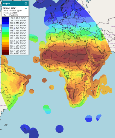
[[Category:Online Data]][[Category:Solar Data]][[File:heliosat_coverage.png|thumb|right|400px|Screenshot from windprospecting.com showing coverage of the Heliosat Solar dataset.]] | [[Category:Online Data]][[Category:Solar Data]][[File:heliosat_coverage.png|thumb|right|400px|Screenshot from windprospecting.com showing coverage of the Heliosat Solar dataset.]] | ||
== Introduction == | == Introduction == | ||
"Heliosat Solar" is a satelite based surface solar | "Heliosat Solar" is a satelite based surface solar irradiance dataset: The raw data are produced and delivered by EUMETSAT CM SAF (Satellite Application Facility on Climate Monitoring) - https://www.cmsaf.eu/. This windPRO 'Heliosat' dataset is a merge of two different datasets, namely:<br> | ||
* '''Surface Radiation Data Set - Heliosat (SARAH) - Edition 2.1:'''<br>This dataset covers the period from 1999-01-01 to 2017-12-31 - see documentation [https://wui.cmsaf.eu/safira/action/viewDoiDetails?acronym=SARAH_V002_01 here]. | * '''Surface Radiation Data Set - Heliosat (SARAH) - Edition 2.1:'''<br>This dataset covers the period from 1999-01-01 to 2017-12-31 - see documentation [https://wui.cmsaf.eu/safira/action/viewDoiDetails?acronym=SARAH_V002_01 here]. | ||
| Line 14: | Line 14: | ||
* '''Coverage:''' The dataset has an extend +- 65 degrees in both latetidues and longitudes. In windPRO, offshore coverage is at a distance of approximately 300 km from any known coastlines. | * '''Coverage:''' The dataset has an extend +- 65 degrees in both latetidues and longitudes. In windPRO, offshore coverage is at a distance of approximately 300 km from any known coastlines. | ||
* '''Period:''' 20+ years. The EMD databases will hold data back to 1999. | * '''Period:''' 20+ years. The EMD databases will hold data back to 1999. | ||
* '''Availability:''' This dataset requires a windPRO version 3.4+ | |||
== Availability from within windPRO == | |||
The data can be accessed and used from windPRO in the following objects: | |||
* Meteo object (data container - online service for obtaining data) | |||
* Solar PV object (calculation tool) | |||
== Data Parameters == | == Data Parameters == | ||
Latest revision as of 22:40, 18 March 2020

Introduction
"Heliosat Solar" is a satelite based surface solar irradiance dataset: The raw data are produced and delivered by EUMETSAT CM SAF (Satellite Application Facility on Climate Monitoring) - https://www.cmsaf.eu/. This windPRO 'Heliosat' dataset is a merge of two different datasets, namely:
- Surface Radiation Data Set - Heliosat (SARAH) - Edition 2.1:
This dataset covers the period from 1999-01-01 to 2017-12-31 - see documentation here. - ICDR SEVIRI Radiation - based on SARAH-2 methods:
This dataset is an operational dataset that covers the period from 2018-01-01 to present - see documentation here
A validation report of the ICDR dataset concludes that there is a resonable consistency between the two datasets, see here.
Dataset Overview
- Content: Surface radition parameters to be used in solar calculations in windPRO
- Spatial Resolution: The dataset is available on a regular geographical (lat/lon) grid at 0.05x0.05 resolution (around 5 km).
- Temporal Resolution: 30 minute values.
- Coverage: The dataset has an extend +- 65 degrees in both latetidues and longitudes. In windPRO, offshore coverage is at a distance of approximately 300 km from any known coastlines.
- Period: 20+ years. The EMD databases will hold data back to 1999.
- Availability: This dataset requires a windPRO version 3.4+
Availability from within windPRO
The data can be accessed and used from windPRO in the following objects:
- Meteo object (data container - online service for obtaining data)
- Solar PV object (calculation tool)
Data Parameters
The windPRO dataset only contains parameters needed for solar calculations. These parameters are listed below.
| Parameter | Unit | Description |
|---|---|---|
| time | UTC time stamp (half hourly) | |
| SIS | w/m2 | Surface Incoming Shortwave Irradiance |
| SID | w/m2 | Surface Irradiance Direct |
All parameters are instantaneous. The two parameters SIS and SID can be used to calculate the diffuse radiation as SIS-SID = diffuse radiation.
Required Modules/Licenses
To access the Heliosat Solar data from within windPRO - the following licenses/modules are required in your windPRO setup:
- BASIS
- METEO
- SOLAR
When the license fee is paid, you then have access to the full dataset without further cost.
Downloading of data is unrestricted for licenced users with an active service subscription, however, a "fair use" policy applies. Visit EMD online ordering to purchase the necessary licences.
Attribution
If data from this dataset is used within any private or public disseminations, then EMD and its data providers must be acknowledged.
Source:
Heliosat Solar. Distribution through EMD and windPRO - EMD International A/S, 2020.
This dataset uses Heliosat Solar data which is being developed by
EUMETSAT CM SAF (Satellite Application Facility on Climate Monitoring) - see https://www.cmsaf.eu/.
External Links
- EUMETSAT CM SAF (Satellite Application Facility on Climate Monitoring) - https://www.cmsaf.eu/