German Hessen Elevation Models: Difference between revisions
m (→Introduction) Tag: Manual revert |
|||
| (22 intermediate revisions by the same user not shown) | |||
| Line 1: | Line 1: | ||
[[Category: Online Data]][[Category: Digital Elevation Models]] | [[Category: Online Data]][[Category: Digital Elevation Models]] | ||
[[File:Hessen-Coverage.png|right|thumb|350px|Coverage of the DTM (DGM). Image credit: HVBG.]] | [[File:Hessen-Coverage.png|right|thumb|350px|Coverage of the DTM (DGM). Image credit: HVBG.]] | ||
[[Image:Hessen-DGM.png|right|thumb|350px|Hessen Elevation Model (DGM)]] | |||
== Introduction == | == Introduction == | ||
The elevation model | The elevation model for the German Bundesland of Hessen is a digital terrain model produced from data originally obtained from the open geodata of Hessen. The source data is produced and delivered by the Hessische Verwaltung für Bodenmanagement und Geoinformation (HVBG). Three elevation models are delivered with windPRO: 1m, 5m and 20m grid resolutions. The original models are available at a maximum resolution of 1m, however, the highest resolution model in windPRO version is also resampled by EMD to obtain a slightly coarser resolutions - 5m and 20m. This is done in order for the data to be operational for the larger domains needed in the context of wind farm analysis’ and wind flow modelling. The 1m grid resolution data is intended for photomontage modelling. Data made available by EMD represents the data status of February 2022. | ||
=== Dataset Overview === | === Dataset Overview === | ||
* '''Spatial Coverage:''' Bundesland of Hessen | * '''Spatial Coverage:''' Bundesland of Hessen | ||
* '''Resolution:''' 5m and 20m (in windPRO) | * '''Resolution:''' 1m, 5m and 20m (in windPRO) | ||
* '''Data-type:''' [[:Category%3ADigital_Elevation_Models#What_type_of_elevation_model.3F_DEM.2C_DSM_and_DTM.3F|Digital Terrain Model (DTM)]] | * '''Data-type:''' [[:Category%3ADigital_Elevation_Models#What_type_of_elevation_model.3F_DEM.2C_DSM_and_DTM.3F|Digital Terrain Model (DTM)]] | ||
* '''Coordinate system''' | * '''Coordinate system''' | ||
| Line 17: | Line 14: | ||
* '''Version:''' Data were downloaded in February 2022. Data originates from years 2009-2020, dependent on area (see map to the right). | * '''Version:''' Data were downloaded in February 2022. Data originates from years 2009-2020, dependent on area (see map to the right). | ||
* '''Accuracy:''' | * '''Accuracy:''' | ||
** Vertical: For the 1m resolution dataset the vertical accuracy is stated to be ±0.3m. For the 5m and | ** ''Vertical:'' For the 1m resolution dataset the vertical accuracy is stated to be ±0.3m. For the 5m and 20m data, it is ±1.1m and ±5.1m respectively. The uncertainty is given as a two-sigma value (95% confidence). | ||
** Horizontal: N/A | ** ''Horizontal:'' N/A | ||
== Usage Notes == | == Usage Notes == | ||
# Download and processing time is in the order of (a few) minutes for the high- | # Download and processing time is in the order of (a few) minutes for the high-resolutions dataset (1m and 5m grid) - so please be patient! <br>Due to the large amounts of high-resolution elevation data and the tile-based storage system (>20000 tiles), you will experience that downloading the data for a site may last a few minutes. If this is a problem for you, please consider downloading 'smaller' areas or downloading the coarser 20m resolution data. | ||
# Please note that for the | # Please note that for the 1-meter grid - the downloaded area is limited to 5 km x 5 km to keep the files at a usable size. For the the 5-meter grid - the downloaded area is limited to 20 km x 20 km. The data within the elevation object may be extended with coarser data for a bigger area if needed. | ||
== Availability from within WindPRO == | == Availability from within WindPRO == | ||
| Line 42: | Line 39: | ||
* Site with description of the elevation model (in German language) - [https://hvbg.hessen.de/geoinformation/landesvermessung/geotopographie/3d-daten/digitale-gel%C3%A4ndemodelle-atkis%C2%AE-dgm HERE] | * Site with description of the elevation model (in German language) - [https://hvbg.hessen.de/geoinformation/landesvermessung/geotopographie/3d-daten/digitale-gel%C3%A4ndemodelle-atkis%C2%AE-dgm HERE] | ||
* Coverage map (pdf) - [https://help.emd.dk/mediawiki/images/a/a3/Hessen-Coverage-Map.pdf HERE] | * Coverage map (pdf) - [https://help.emd.dk/mediawiki/images/a/a3/Hessen-Coverage-Map.pdf HERE] | ||
* Information on open geodata in Hessen - [https://hvbg.hessen.de/open-data HERE] | |||
[[File:ImmenhausenDGM5.png|center|thumb|600px|Hessen DGM5 - windPRO elevation model at the windPRO sample project of Immenhausen.]] | |||
Latest revision as of 19:53, 12 June 2024


Introduction
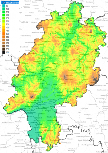
The elevation model for the German Bundesland of Hessen is a digital terrain model produced from data originally obtained from the open geodata of Hessen. The source data is produced and delivered by the Hessische Verwaltung für Bodenmanagement und Geoinformation (HVBG). Three elevation models are delivered with windPRO: 1m, 5m and 20m grid resolutions. The original models are available at a maximum resolution of 1m, however, the highest resolution model in windPRO version is also resampled by EMD to obtain a slightly coarser resolutions - 5m and 20m. This is done in order for the data to be operational for the larger domains needed in the context of wind farm analysis’ and wind flow modelling. The 1m grid resolution data is intended for photomontage modelling. Data made available by EMD represents the data status of February 2022.
Dataset Overview
- Spatial Coverage: Bundesland of Hessen
- Resolution: 1m, 5m and 20m (in windPRO)
- Data-type: Digital Terrain Model (DTM)
- Coordinate system
- Horizontal: ETRS89/UTM32 (EPSG 25832)
- Vertical: N/A
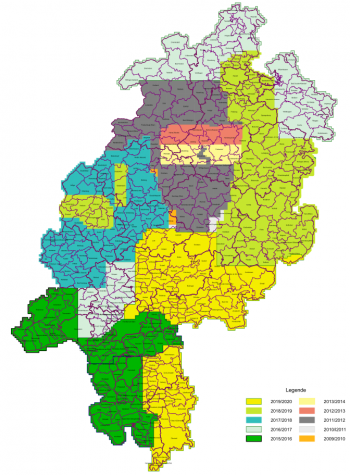
- Version: Data were downloaded in February 2022. Data originates from years 2009-2020, dependent on area (see map to the right).
- Accuracy:
- Vertical: For the 1m resolution dataset the vertical accuracy is stated to be ±0.3m. For the 5m and 20m data, it is ±1.1m and ±5.1m respectively. The uncertainty is given as a two-sigma value (95% confidence).
- Horizontal: N/A
Usage Notes
- Download and processing time is in the order of (a few) minutes for the high-resolutions dataset (1m and 5m grid) - so please be patient!
Due to the large amounts of high-resolution elevation data and the tile-based storage system (>20000 tiles), you will experience that downloading the data for a site may last a few minutes. If this is a problem for you, please consider downloading 'smaller' areas or downloading the coarser 20m resolution data. - Please note that for the 1-meter grid - the downloaded area is limited to 5 km x 5 km to keep the files at a usable size. For the the 5-meter grid - the downloaded area is limited to 20 km x 20 km. The data within the elevation object may be extended with coarser data for a bigger area if needed.
Availability from within WindPRO
The data are available directly from within windPRO in 5-meter and 20-meter grid resolution. The data can be accessed from the online-services in the following objects:
- Line Object (with purpose to height contour lines)
- Elevation Grid Object
License and Attribution
The data is based on open geo-data of Hessen, released under a open-data policy on February 1st 2022.
When using the dataset, the please acknowledge the origin of the data, such as:
EMD/windPRO elevation model based on data from Hessische Verwaltung für Bodenmanagement und Geoinformation (HVBG).
The usage conditions are available from this pdf from HVBG - here.
Acknowledgement
- The HVBG are thanked for producing this digital elevation dataset – and disseminating it in the public domain and thus for aiding the development of renewable energy and wind energy in particular.
External Links and Documentation
- Site with description of the elevation model (in German language) - HERE
- Coverage map (pdf) - HERE
- Information on open geodata in Hessen - HERE
