Slovakian Elevation Models: Difference between revisions
No edit summary |
|||
| (20 intermediate revisions by 2 users not shown) | |||
| Line 1: | Line 1: | ||
[[Category: Online Data]][[Category: Digital Elevation Models]] | [[Category: Online Data]][[Category: Digital Elevation Models]][[Category: Very-High Resolution Digital Surface Models - (DSMs)]] | ||
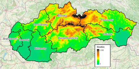
[[Image:Skovakia_ElevationModel-DTM-10m_SMALL.png|right|thumb|450px|Slovakian Digital Terrain Model (DTM) - 10m grid resolution.]] | [[Image:Skovakia_ElevationModel-DTM-10m_SMALL.png|right|thumb|450px|Slovakian Digital Terrain Model (DTM) - 10m grid resolution.]] | ||
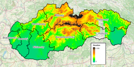
[[Image:Skovakia_ElevationModel-DSM-5m_SMALL.png|right|thumb|450px|Slovakian Digital Surface Model (DSM) - 5m grid resolution.]] | [[Image:Skovakia_ElevationModel-DSM-5m_SMALL.png|right|thumb|450px|Slovakian Digital Surface Model (DSM) - 5m grid resolution.]] | ||
== Introduction == | == Introduction == | ||
The Slovakian Digital Terrain Model (DTM) and Slovakian Digital Surface Model (DSM) in windPRO are seamless digital elevation models (DEMs) that covers almost the whole of the Slovakian territory. Source data is released from the "Geodesy, Cartography and Cadastre Authority of the Slovak Republic (ÚGKK SR)" - and is processed, formatted and adapted for | The Slovakian Digital Terrain Model (DTM) and Slovakian Digital Surface Model (DSM) in windPRO are seamless digital elevation models (DEMs) that covers almost the whole of the Slovakian territory. Source data is released from the "Geodesy, Cartography and Cadastre Authority of the Slovak Republic (ÚGKK SR)" - and is processed, formatted and adapted for dedicated windPRO use by EMD. The original DEMs are made from multiple regional measurement campaigns using airborne lidar scanning systems (ALS). In windPRO, we deliver the DTM with a 10m grid resolution and the DSM with a 5m grid resolution. More grid-resolutions are available from the ÚGKK SR geoportal. | ||
=== Dataset Overview === | === Dataset Overview === | ||
* '''Spatial Coverage:''' Slovakia | * '''Spatial Coverage:''' Slovakia | ||
* '''Grid Resolutions:''' | * '''Grid Resolutions (in windPRO):''' | ||
** DTM: 10m | ** DTM: 10m (down-to 5m in ÚGKK SR source data) | ||
** DSM: 5m | ** DSM: 5m (down-to 1m in ÚGKK SR source data) | ||
* '''Data-types:''' [[:Category%3ADigital_Elevation_Models#What_type_of_elevation_model.3F_DEM.2C_DSM_and_DTM.3F|Digital Terrain Model (DTM) and Digital Surface Model (DSM)]] | * '''Data-types:''' [[:Category%3ADigital_Elevation_Models#What_type_of_elevation_model.3F_DEM.2C_DSM_and_DTM.3F|Digital Terrain Model (DTM) and Digital Surface Model (DSM)]] | ||
* '''Coordinate system:''' | * '''Coordinate system:''' | ||
| Line 19: | Line 18: | ||
== Usage Notes == | == Usage Notes == | ||
* For the DSM data, some data are missing in south-eastern part the country (within central Prešovský and Košice regions) - see the map-image to the top-right. | * '''Available in windPRO version 4.0+''': This dataset is available from windPRO version 4.0 (from build #416). This is due to the coordinate-system being used in the data-source; this was added in 4.0. So, in order to use this dataset, the project must be created in windpro 4.0+ - and unfortunately this dataset is not available in earlier versions of windPRO. | ||
* '''Missing DSM data''': For the DSM data, some data are missing in south-eastern part the country (within central Prešovský and Košice regions) - see the map-image to the top-right. | |||
== Availability from within WindPRO == | == Availability from within WindPRO == | ||
| Line 27: | Line 27: | ||
== License and Attribution == | == License and Attribution == | ||
The | These products are derived from open source data released by "Geodesy, Cartography and Cadastre Authority of the Slovak Republic (ÚGKK SR)". The ALR source data are released according to a national open source license ([https://help.emd.dk/mediawiki/images/6/65/Terms_and_conditions_of_provision_and_use_als.pdf here]) and the derived 10m-DTM using the Creative Commons by Attribution 4.0 license ([https://creativecommons.org/licenses/by/4.0/ here]), see further below. When using these data, please remember to acknowledge the source of information and use a proper attribution when using this dataset, such as: <br> | ||
<pre> | <pre> | ||
10m-DTM: Contains: Modified elevation data from the "Geodesy, Cartography and Cadastre Authority of the Slovak Republic (ÚGKK SR)". Adapted and distributed by EMD and windPRO. License CC-BY-40. | 10m-DTM: | ||
Contains: Modified elevation data from the "Geodesy, Cartography and Cadastre Authority of the Slovak Republic (ÚGKK SR)". Adapted and distributed by EMD and windPRO. License CC-BY-40. | |||
5m-DSM: Contains: Modified elevation data from the "Geodesy, Cartography and Cadastre Authority of the Slovak Republic (ÚGKK SR)". Adapted and distributed by EMD and windPRO. | 5m-DSM: | ||
Contains: Modified elevation data from the "Geodesy, Cartography and Cadastre Authority of the Slovak Republic (ÚGKK SR)". Adapted and distributed by EMD and windPRO. | |||
</pre> | </pre> | ||
== Acknowledgement == | == Acknowledgement == | ||
* The | * The "Geodesy, Cartography and Cadastre Authority of the Slovak Republic (ÚGKK SR)" are thanked for producing this digital elevation dataset – and disseminating it in the public domain and thus for aiding the development of renewable energy. | ||
== External Links == | == External Links == | ||
* Geo-portal with description of the Slovakian elevation models - [https://www.geoportal.sk HERE] | * Geo-portal with description of the Slovakian elevation models - [https://www.geoportal.sk HERE] | ||
Latest revision as of 21:34, 21 March 2025


Introduction
The Slovakian Digital Terrain Model (DTM) and Slovakian Digital Surface Model (DSM) in windPRO are seamless digital elevation models (DEMs) that covers almost the whole of the Slovakian territory. Source data is released from the "Geodesy, Cartography and Cadastre Authority of the Slovak Republic (ÚGKK SR)" - and is processed, formatted and adapted for dedicated windPRO use by EMD. The original DEMs are made from multiple regional measurement campaigns using airborne lidar scanning systems (ALS). In windPRO, we deliver the DTM with a 10m grid resolution and the DSM with a 5m grid resolution. More grid-resolutions are available from the ÚGKK SR geoportal.
Dataset Overview
- Spatial Coverage: Slovakia
- Grid Resolutions (in windPRO):
- DTM: 10m (down-to 5m in ÚGKK SR source data)
- DSM: 5m (down-to 1m in ÚGKK SR source data)
- Data-types: Digital Terrain Model (DTM) and Digital Surface Model (DSM)
- Coordinate system:
- Horizontal: S-JTSK / Krovak East North (EPSG: 5514)
- Vertical: Baltic
- Version: Data downloaded in august 2023. DTM is derived from 'Digital Terrain Model DMR3.5' and DSM derived from "DSM 1.0" from ALS project 1st cycle.
- Vertical Accuracy: N/A
Usage Notes
- Available in windPRO version 4.0+: This dataset is available from windPRO version 4.0 (from build #416). This is due to the coordinate-system being used in the data-source; this was added in 4.0. So, in order to use this dataset, the project must be created in windpro 4.0+ - and unfortunately this dataset is not available in earlier versions of windPRO.
- Missing DSM data: For the DSM data, some data are missing in south-eastern part the country (within central Prešovský and Košice regions) - see the map-image to the top-right.
Availability from within WindPRO
The data are available directly from within windPRO in 5-meter and 10-meter grid resolutions for the DSM and the DTM respectively. The data can be accessed from the online-services in the following objects:
- Line Object (with purpose to height contour lines)
- Elevation Grid Object
License and Attribution
These products are derived from open source data released by "Geodesy, Cartography and Cadastre Authority of the Slovak Republic (ÚGKK SR)". The ALR source data are released according to a national open source license (here) and the derived 10m-DTM using the Creative Commons by Attribution 4.0 license (here), see further below. When using these data, please remember to acknowledge the source of information and use a proper attribution when using this dataset, such as:
10m-DTM:
Contains: Modified elevation data from the "Geodesy, Cartography and Cadastre Authority of the Slovak Republic (ÚGKK SR)". Adapted and distributed by EMD and windPRO. License CC-BY-40.

5m-DSM:
Contains: Modified elevation data from the "Geodesy, Cartography and Cadastre Authority of the Slovak Republic (ÚGKK SR)". Adapted and distributed by EMD and windPRO.
Acknowledgement
- The "Geodesy, Cartography and Cadastre Authority of the Slovak Republic (ÚGKK SR)" are thanked for producing this digital elevation dataset – and disseminating it in the public domain and thus for aiding the development of renewable energy.
External Links
- Geo-portal with description of the Slovakian elevation models - HERE