Rhineland-Palatinate Elevation Model: Difference between revisions
Jump to navigation
Jump to search
mNo edit summary |
|||
| (One intermediate revision by the same user not shown) | |||
| Line 1: | Line 1: | ||
[[Category: Online Data]][[Category: Digital Elevation Models]][[Category: German Elevation Models]] | [[Category: Online Data]][[Category: Digital Elevation Models]][[Category: German Elevation Models]] | ||
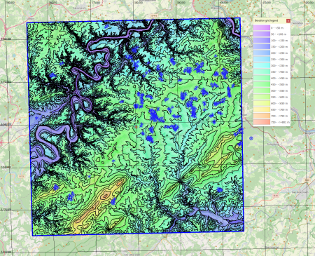
[[File:Rhineland-PalatinateElevationModel.png|right|thumb|450px|Rhineland-Palatinate Elevation Model (DGM)<br>With 324 wind turbines from the MAsTR database.]] | [[File:Rhineland-PalatinateElevationModel.png|right|thumb|450px|Rhineland-Palatinate Elevation Model (DGM) - at work in windPRO.<br>With 324 wind turbines from the MAsTR database.]] | ||
== Introduction == | == Introduction == | ||
The digital elevation model for the German federal state of Rhineland-Palatinate (Rheinland-Pfalz) is derived from open geodata specific to this region. The original model in 25m grid-resolution is provided by the Landesamt für Vermessung und Geobasisinformation. In windPRO we currently have the version from year 2017 in 25m grid resolution. | The digital elevation model for the German federal state of Rhineland-Palatinate (Rheinland-Pfalz) is derived from open geodata specific to this region. The original model in 25m grid-resolution is provided by the Landesamt für Vermessung und Geobasisinformation. In windPRO we currently have the version from year 2017 in 25m grid resolution. | ||
| Line 30: | Line 30: | ||
== External Links and Documentation == | == External Links and Documentation == | ||
* Landesamt für Vermessung und Geobasisinformation Rheinland-Pfalz - [https://geoshop.rlp.de/opendata-dgm1.html HERE] | * Landesamt für Vermessung und Geobasisinformation Rheinland-Pfalz - [https://geoshop.rlp.de/opendata-dgm1.html HERE] | ||
* Product Sheet for DTM (in german) - [HERE] | * Product Sheet for DTM (in german) - [https://help.emd.dk/mediawiki/images/a/af/DGM-RheinlandPfalz.pdf HERE] | ||
Latest revision as of 07:56, 12 April 2025

With 324 wind turbines from the MAsTR database.
Introduction
The digital elevation model for the German federal state of Rhineland-Palatinate (Rheinland-Pfalz) is derived from open geodata specific to this region. The original model in 25m grid-resolution is provided by the Landesamt für Vermessung und Geobasisinformation. In windPRO we currently have the version from year 2017 in 25m grid resolution.
Dataset Overview
- Spatial Coverage: Bundesland of Rheinland Pfalz
- Resolution: 25m (in windPRO)
- Data-type: Digital Terrain Model (DTM)
- Coordinate system
- Horizontal: ETRS89/UTM32 (EPSG 25832)
- Vertical: DHHN2016 (EPSG: 7837)
- Version: Data were downloaded in 2019
- Accuracy:
- Vertical: For the 1m resolution dataset the vertical accuracy is stated to be ±0.10m + 5% of the grid-resolution.
- Horizontal: N/A
- No-data value: N/A
License and Attribution
The data is based on open geo-data of Rhineland-Palatinate, released under a open-data policy. When using the dataset, the please acknowledge the origin of the data, such as:
Source/Datenquelle: Landesamt für Vermessung und Geobasisinformation Rheinland-Pfalz
License: Datenlizenz Deutschland – Namensnennung – Version 2.0 (dl-de/by-2-0) - www.govdata.de/dl-de/by-2-0
Distribution: EMD/windPRO elevation model based on data from Landesamt für Vermessung und Geobasisinformation Rheinland-Pfalz
Acknowledgement
- The Landesamt für Vermessung und Geobasisinformation Rheinland-Pfalz are thanked for producing this digital elevation dataset – and disseminating it in the public domain and thus for aiding the development of renewable energy and wind energy in particular.