Swedish SLU Forest Map: Difference between revisions
No edit summary |
m (→Introduction) |
||
| (3 intermediate revisions by 2 users not shown) | |||
| Line 1: | Line 1: | ||
[[Category: Online Data]][[Category: Forest Maps]] | [[Category: Online Data]][[Category: Forest Maps]][[Category: InnoWind]] | ||
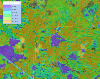
[[File:SLU-ForestMap-Sweden.png|right|thumb|350px|SLU Forest Map – Site Near Oskarshamn, Sweden.]] | [[File:SLU-ForestMap-Sweden.png|right|thumb|350px|SLU Forest Map – Site Near Oskarshamn, Sweden.]] | ||
== Introduction == | == Introduction == | ||
| Line 5: | Line 5: | ||
Currently (2018), forest maps are available for years 2010, 2005 and 2000. In windPRO we distribute the latest version from 2010. | Currently (2018), forest maps are available for years 2010, 2005 and 2000. In windPRO we distribute the latest version from 2010. | ||
=== Usage Notes === | |||
# SLU states that the map primarily intended for use with larger areas of forest, so if the area is less than a few hundred hectares then the information should be used with a degree of caution. | # SLU states that the map primarily intended for use with larger areas of forest, so if the area is less than a few hundred hectares then the information should be used with a degree of caution. | ||
# EMD recommends that you validate the map against recent orthophotos or satellite images (see below) - with special emphasis on areas with no-data values | # EMD recommends that you validate the map against recent orthophotos or satellite images (see below) - with special emphasis on areas with no-data values | ||
| Line 36: | Line 36: | ||
== Acknowledgement == | == Acknowledgement == | ||
* The Swedish University of Agricultural Sciences, Department of Forest Resource Management, Swedish University of Agricultural Sciences are acknowledged for development and release of the free and open dataset of forest heights. | |||
* Development and Integration of this dataset into EMD services was co-supported through the InnoWind project ([http://www.innowind.dk www.innowind.dk) which is co-funded by the Danish Innovation Fund | |||
== External Links == | == External Links == | ||
# SLU Forest Map: https://www.slu.se/en/Collaborative-Centres-and-Projects/the-swedish-national-forest-inventory/forest-statistics/slu-forest-map/ | # SLU Forest Map: https://www.slu.se/en/Collaborative-Centres-and-Projects/the-swedish-national-forest-inventory/forest-statistics/slu-forest-map/ | ||
# InnoWind Project: http://www.innowind.dk | # InnoWind Project: http://www.innowind.dk | ||
Latest revision as of 15:04, 2 June 2020

Introduction
The Swedish University of Agricultural Sciences (SLU) is developing and updating a forest map with Swedish National coverage. The map is developed using a ‘k nearest neighbors’ method driven by data obtained from a combination of LANDSAT and SPOT satellite images along with field data from the Swedish National Forest Inventory. The map holds a spatial coverage for the most of Sweden – with a grid resolution of 25m. In WindPRO we use the forest height data, but the original dataset also holds information about forest age, species and standing volume. Currently (2018), forest maps are available for years 2010, 2005 and 2000. In windPRO we distribute the latest version from 2010.
Usage Notes
- SLU states that the map primarily intended for use with larger areas of forest, so if the area is less than a few hundred hectares then the information should be used with a degree of caution.
- EMD recommends that you validate the map against recent orthophotos or satellite images (see below) - with special emphasis on areas with no-data values
- EMD recommends that you validate the SLU forest heights by in-situ inspections - with the goal to adjust for recent forest growth and felling - a correction factor can be easily applied in the 'displacement height calculator' of windPRO
- Data is typically stored in 'elevation grid object'
- Data is typically used used for analysis of the annual energy production - with data as displacement heights or/and as input to the Objective Roughness Approach (ORA)
Availability from within WindPRO
The forest height data is available directly from within windPRO in 25 meter resolution. The data can be accessed from the online-services in the 'Elevation Grid Object' in the following way.
- Open the 'Elevation Grid Object'.
- Select ‘Data type’ to ‘Heights above terrain (a.g.l) for “elements”.
- Click ‘Add Layer from Online Data‘.
Data Type and Use in windPRO
The Swedish SLU Forest Map are delivered as gridded data with a spatial resolution of 25 meters. It holds the tree height data as of 2010. The data is used for forest modelling - and is very helpful in for establishing the displacement heights as well as the added roughness for the Objective Roughness Approach (ORA) model. When you have loaded the data in windPRO, we recommend that you validate the location of the forest patches against recent satellite imagery, which can be done like this:
- Select background map - ‘EMD Global Satellite Imagery – 10m’ (this holds most recent satellite imagery) – or alternative windPRO European Satellite Imagery – 2.5m) – you will be able to see forest patches on these images
- Locate the key locations (such as mast and turbine locations)
- Inspect if the model has missed some of these ares (could be areas with no forest records)
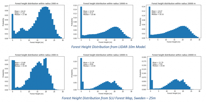
An example of the distribution of forest heights from the model is shown below - along with a comparison with a LIDAR scan at the same site. The distribution is plottet at distances 2000m, 10000m and 20000m from the center of the wind farm. The distributions are very similar, but with the SLU Forest Map to predict tree heights at a slightly lower level.

Coverage
This dataset covers Sweden.
License
The map is in the public domain. SLU has made the data available free of charge.
Acknowledgement
- The Swedish University of Agricultural Sciences, Department of Forest Resource Management, Swedish University of Agricultural Sciences are acknowledged for development and release of the free and open dataset of forest heights.
- Development and Integration of this dataset into EMD services was co-supported through the InnoWind project ([http://www.innowind.dk www.innowind.dk) which is co-funded by the Danish Innovation Fund