Australian Elevation Models: Difference between revisions
mNo edit summary |
No edit summary |
||
| (12 intermediate revisions by one other user not shown) | |||
| Line 11: | Line 11: | ||
Please consult the user guide (see link below) for more details. | Please consult the user guide (see link below) for more details. | ||
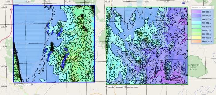
[[Image:AustralianDEMLakeGeorge2.png|right|thumb|700px|Australian DEMs at Lake George. Left: 1-arc-second data. Right: 1-arc-second (smoothened).]] | |||
=== Dataset Overview === | |||
* '''Spatial Coverage:''' Australia | |||
* '''Resolution:''' 1 arc-second (30m) | |||
* '''Data-type:''' [[:Category%3ADigital_Elevation_Models#What_type_of_elevation_model.3F_DEM.2C_DSM_and_DTM.3F|Digital Terrain Model (DTM)]] - bare ground (but with buildings) | |||
* '''Coordinate system:''' Geographic WGS (EPSG:4326) | |||
* '''Version:''' WindPRO holds the version 1.0 (downloaded medio 2019) | |||
* '''Vertical Accuracy:''' N/A | |||
== Availability from within WindPRO == | == Availability from within WindPRO == | ||
| Line 16: | Line 25: | ||
* Line Object (with purpose to height contour lines) | * Line Object (with purpose to height contour lines) | ||
* Elevation Grid Object | * Elevation Grid Object | ||
== License and Attribution == | == License and Attribution == | ||
The product belongs to the open data of Geoscience Australia. The data have been licensed under a ‘Creative Commons Attribution 3.0 Australia Licence’ in its version 2 from 2012 [ | The product belongs to the open data of Geoscience Australia. The data have been licensed under a ‘Creative Commons Attribution 3.0 Australia Licence’ in its version 2 from 2012 - see [http://help.emd.dk/mediawiki/images/1/1b/NEDF_CClicence_template.pdf here].<br> | ||
Please accept the license conditions and use a proper attribution when using this dataset, such as: | |||
<pre> | <pre> | ||
Contains: Elevation data from Geoscience Australia, Department of Resources, Energy and Tourism, Canberra, Australia. | Contains: Elevation data from Geoscience Australia, Department of Resources, Energy and Tourism, Canberra, Australia. | ||
| Line 31: | Line 37: | ||
== Acknowledgement == | == Acknowledgement == | ||
* Geoscience Australia and the pubic of Australia are thanked for producing this digital elevation dataset – and disseminating it in the public domain - and thus for aiding the development of renewable energy. | * Geoscience Australia and the pubic of Australia are thanked for producing this digital elevation dataset – and disseminating it in the public domain - and thus for aiding the development of renewable energy. | ||
* Integration of this dataset into EMD services | * Integration of this dataset into EMD services was co-supported through the InnoWind project (www.innowind.dk) which is co-funded by the Danish Innovation Fund | ||
== External Links == | == External Links == | ||
* Description of the elevation models from Geoscience Australia - [ | * Description of the elevation models from Geoscience Australia - [http://www.ga.gov.au/scientific-topics/national-location-information/digital-elevation-data HERE] | ||
* InnoWind Project - [http://www.innowind.dk HERE] | * InnoWind Project - [http://www.innowind.dk HERE] | ||
* User | * User Guide - pdf-file - [http://help.emd.dk/mediawiki/images/c/cc/1secSRTM_Derived_DEMs_UserGuide_v1.0.4.pdf HERE] | ||
Latest revision as of 09:50, 17 January 2020

Introduction
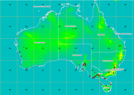
The Australian elevation models in 1-arc-second resolution are digital terrain models (DTM’s) produced by Geoscience Australia. The models are derived from the SRTM 1 second data – with vegetation features being removed using an automated process. Currently, two Australian DTM models are available from windPRO. These are listed below - with their descriptions provided by the reference documentation from Geoscience Australia:
1. Australian DEM – 1 arc second
The Australian DEM represents ground surface topography, with vegetation features removed using an automatic process supported by several vegetation maps. This provides substantial improvements in the quality and consistency of the data relative to the original SRTM data, but is not free from artefacts. Man-made structures such as urban areas and power line towers have not been treated. The removal of vegetation effects has produced satisfactory results over most of the continent and areas with defects identified in supplementary layers distributed with the data and described in the User Guide.
2. Australian DEM-S – 1 arc second (smoothened version)
Australian DEM-S represents ground surface topography, excluding vegetation features, and has been smoothed to reduce noise and improve the representation of surface shape. An adaptive smoothing process applied more smoothing in flatter areas than hilly areas, and more smoothing in noisier areas than in less noisy areas. This DEM-S supports calculation of local terrain shape attributes such as slope, aspect and curvature that could not be reliably derived from the unsmoothed 1 second DEM because of noise.
Please consult the user guide (see link below) for more details.

Dataset Overview
- Spatial Coverage: Australia
- Resolution: 1 arc-second (30m)
- Data-type: Digital Terrain Model (DTM) - bare ground (but with buildings)
- Coordinate system: Geographic WGS (EPSG:4326)
- Version: WindPRO holds the version 1.0 (downloaded medio 2019)
- Vertical Accuracy: N/A
Availability from within WindPRO
The data are available directly from within windPRO in 1-arc-second (~30-meter) resolution. The data can be accessed from the online-services in the following objects:
- Line Object (with purpose to height contour lines)
- Elevation Grid Object
License and Attribution
The product belongs to the open data of Geoscience Australia. The data have been licensed under a ‘Creative Commons Attribution 3.0 Australia Licence’ in its version 2 from 2012 - see here.
Please accept the license conditions and use a proper attribution when using this dataset, such as:
Contains: Elevation data from Geoscience Australia, Department of Resources, Energy and Tourism, Canberra, Australia.
© Commonwealth of Australia (Geoscience Australia).
Distribution through EMD and windPRO.
Acknowledgement
- Geoscience Australia and the pubic of Australia are thanked for producing this digital elevation dataset – and disseminating it in the public domain - and thus for aiding the development of renewable energy.
- Integration of this dataset into EMD services was co-supported through the InnoWind project (www.innowind.dk) which is co-funded by the Danish Innovation Fund