Danish Elevation Model: Difference between revisions
mNo edit summary |
mNo edit summary |
||
| Line 14: | Line 14: | ||
* DHM 0.4m grid surface - DHM 0.4m grid (overflade/surface) | * DHM 0.4m grid surface - DHM 0.4m grid (overflade/surface) | ||
* DHM 0.4m grid terrain - DHM 0.4m grid terræn | * DHM 0.4m grid terrain - DHM 0.4m grid terræn | ||
=== Dataset Overview === | === Dataset Overview === | ||
| Line 22: | Line 20: | ||
* '''Data-type:''' [[:Category%3ADigital_Elevation_Models#What_type_of_elevation_model.3F_DEM.2C_DSM_and_DTM.3F|Digital Terrain Models (DTM) and Digital Surface Models (DSM)]] | * '''Data-type:''' [[:Category%3ADigital_Elevation_Models#What_type_of_elevation_model.3F_DEM.2C_DSM_and_DTM.3F|Digital Terrain Models (DTM) and Digital Surface Models (DSM)]] | ||
* '''Coordinate system:''' Austrian Lambert (EPSG 31287) in original data | * '''Coordinate system:''' Austrian Lambert (EPSG 31287) in original data | ||
* '''Version:''' Data downloaded in | * '''Version:''' Data downloaded in 2013. | ||
* '''Vertical Accuracy:''' 0.05m (for original 0.4m grided data) | * '''Vertical Accuracy:''' 0.05m (for original 0.4m grided data) | ||
Revision as of 09:54, 24 June 2020
Introduction

The Danish Elevation Model dataset (DHM - Danmarks Højdemodel) holds records of the heights in the Danish landscape with reference to the sea as its basic zero-level. The Danish Elevation Model data is available in WindPRO in four different verions: one based on gridded raw data sources and three based on raw vector data sources. The data sources are (with the official Danish name given last):
DTM-Models:
- DHM 10m gridded data - DHM/Terræn
- DHM 2.5m contour lines - DHM/Højdekurver
- DHM 5.0m contour lines - DHM/Højdekurver
- DHM 10.0m contour lines - DHM/Højdekurver
DSM-Models:
- DHM 0.4m grid surface - DHM 0.4m grid (overflade/surface)
- DHM 0.4m grid terrain - DHM 0.4m grid terræn
Dataset Overview
- Spatial Coverage: Denmark
- Resolution: 0.4m, 2.5m, 5.0m, 10.0 m
- Data-type: Digital Terrain Models (DTM) and Digital Surface Models (DSM)
- Coordinate system: Austrian Lambert (EPSG 31287) in original data
- Version: Data downloaded in 2013.
- Vertical Accuracy: 0.05m (for original 0.4m grided data)
Coverage

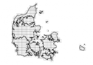
These dataset covers Denmark, see the picture to the right.
Availability in WindPRO
The all four datasets are available from the WindPRO online services.
Licence and Acknowledgement
The data are distributed according to the terms of use for free geographical data in Denmark: 'Terms and Conditions'. As stated in the conditions, please take proper care to add proper attribution in order to acknowledge the source of information. Typically, this is done by adding the following statement to your report-picture or map:
In Danish:
Indeholder data fra Geodatastyrelsen, [datasæt-navn], [år]
In English:
Contains data from the Danish Geodata Agency, [dataset-name], [year]
Raw Data
Contour lines originate from DHM/Højdekurver: That is, the three contour lines datasets (with 2.5m, 5.0m and 10.0m contour separation) were processed by EMD from the original dataset as lines with 0.5 m contour separation. The raw contour data is available in either TAB or SHP format (i.e. map formats for MapInfo or ArcMap). Vector data originate from DHM/Terræn.
External Links
- Original 10 m grid data files available from the Danish 'Kortforsyning' http://download.kortforsyningen.dk/content/dhmterr%C3%A6n-10-m-grid.
- Original 0.5 m contour files: http://download.kortforsyningen.dk/content/dhmh%C3%B8jdekurver-05-m-%C3%A6kvidistance.
- All geo-data products from the Danish Geodata Agency: http://download.kortforsyningen.dk/content/geodataprodukter