UK-Land-Form PANORAMA: Difference between revisions
Jump to navigation
Jump to search
| Line 1: | Line 1: | ||
[[Category: Online Data]][[Category: Digital Elevation Models]] | [[Category: Online Data]][[Category: Digital Elevation Models]] | ||
== Introduction == | == Introduction == | ||
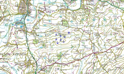
[[File:LandFormPANORAMA.jpg|right|400px|thumb|Land-Form PANORAMA data shown at the Milton Keynes Wind Farm. Picture contains Ordnance Survey data © Crown copyright and database right | [[File:LandFormPANORAMA.jpg|right|400px|thumb|Land-Form PANORAMA data shown at the Milton Keynes Wind Farm. Picture contains Ordnance Survey data © Crown copyright and database right 2013]]The Land-Form PANORAMA is a digital elevation dataset for Great Britain: Two versions of the dataset exists: one vector-dataset that provides height contours with a 10 m vertical spacing and one gridded dataset with a grid-spacing of 50 m. | ||
== Coverage == | == Coverage == | ||
Revision as of 20:43, 23 May 2013
Introduction

The Land-Form PANORAMA is a digital elevation dataset for Great Britain: Two versions of the dataset exists: one vector-dataset that provides height contours with a 10 m vertical spacing and one gridded dataset with a grid-spacing of 50 m.
Coverage
This dataset covers the whole Great Britain.
Licence and Acknowledgement
The data is distributed according to the OS OpenData terms . Please take proper care to add proper atribution in order to acknowledge the source of information. Typically, this is done by adding the following statement to your report-picture or map:
Contains Ordnance Survey data © Crown copyright and database right [year]
Raw Data Types
- Raw vector data is stored in the DXF-format.
- Grid data is stored in either ASCII-Grid or NTF-format.
External Links
- Original data is available from the web-page of the Ordnance Survey http://www.ordnancesurvey.co.uk/oswebsite/products/land-form-panorama/index.html.
- OS OpenData Terms / Licence is available here: http://www.ordnancesurvey.co.uk/oswebsite/docs/licences/os-opendata-licence.pdf.