Canadian Elevation Models: Difference between revisions
No edit summary |
|||
| Line 2: | Line 2: | ||
[[Category: Online Data]][[Category: Digital Elevation Models]] | [[Category: Online Data]][[Category: Digital Elevation Models]] | ||
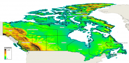
[[Image:canada_elevation_model_20m.png|right|thumb|450px|Canadian DEM (CDEM).]] | [[Image:canada_elevation_model_20m.png|right|thumb|450px|Canadian DEM (CDEM).]] | ||
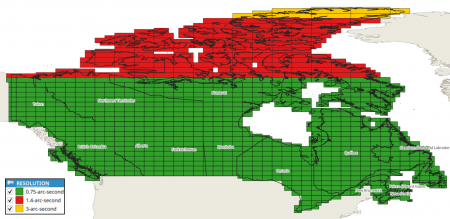
[[Image:canada_elevation_model_resolution.png|right|thumb|450px|Canadian DEM (CDEM) - tiles with their resolution.]] | |||
== Introduction == | == Introduction == | ||
The Canadian elevation model in its 0.75-arc-second resolution is a digital elevation model (DEM’s) produced by Natural Resources Canada (NRCan). CDEM is mainly based on elevation contours and hydrographic data from NRCan's Geospatial Data Base at the scale of 1:50,000, or at other scales provided by other provinces and territories. Temporal coverage is 1945-2011. | The Canadian elevation model in its 0.75-arc-second resolution is a digital elevation model (DEM’s) produced by Natural Resources Canada (NRCan). CDEM is mainly based on elevation contours and hydrographic data from NRCan's Geospatial Data Base at the scale of 1:50,000, or at other scales provided by other provinces and territories. Temporal coverage is 1945-2011. | ||
Revision as of 15:57, 7 August 2024
NOTE 2024-08-04: This dataset is currently being integrated with windPRO.


Introduction
The Canadian elevation model in its 0.75-arc-second resolution is a digital elevation model (DEM’s) produced by Natural Resources Canada (NRCan). CDEM is mainly based on elevation contours and hydrographic data from NRCan's Geospatial Data Base at the scale of 1:50,000, or at other scales provided by other provinces and territories. Temporal coverage is 1945-2011.
Please consult the product-specification (see link below) for more details.
Dataset Overview
- Spatial Coverage: Canada
- Resolution:
- 0.75 arc-second (approximately 20m) in windPRO
(resampled with a bi-linear algorithm, if needed, so windPRO data is always delivered with a 0.75 arc-second resolution) - Source data: In-general: 0.75 arc-second resolution below N69, 3-arc-seconds north of N81. Other areas are typically with a 1.4 arc-second resolution (see image to the right).
- 0.75 arc-second (approximately 20m) in windPRO
- Data-type: Digital Elevation Model (DEM)
- Coordinate system:
- Horizontal: Geographic WGS - NAD83 (EPSG:4617)
- Vertical: Canadian Height Reference System, 1928 (CGVD28)
- Version: WindPRO holds the version 1.0 (downloaded august 2024)
- Vertical Accuracy: N/A
Availability from within WindPRO
The data are available directly from within windPRO in 1-arc-second (~20-meter) resolution. The data can be accessed from the online-services in the following objects:
- Line Object (with purpose to height contour lines)
- Elevation Grid Object
License and Attribution
The product belongs to the open data of Natural Resources Canada (NRCan). The data have been licensed under a ‘ Open Government Licence – Canada (version 2.0)' - see here. Please accept the license conditions and use a proper attribution when using this dataset, such as:
Contains: CDEM elevation data from Natural Resources Canada (NRCan).
License:  Open Government Licence – Canada.
Source: Distribution through EMD and windPRO.
Acknowledgement
- Natural Resources Canada (NRCan) and the pubic of Canada are thanked for producing this digital elevation dataset – and disseminating it in the public domain - and thus for aiding the development of renewable energy.