Swedish Elevation Model: Difference between revisions
No edit summary |
mNo edit summary |
||
| Line 1: | Line 1: | ||
[[Category: Online Data]][[Category: Digital Elevation Models]] | [[Category: Online Data]][[Category: Digital Elevation Models]][[Category: InnoWind]] | ||
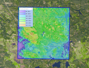
[[Image:ExampleGSDSweden.png|right|thumb|300px|GSD Data in WindPRO - Site near Oscarshamn.]] | [[Image:ExampleGSDSweden.png|right|thumb|300px|GSD Data in WindPRO - Site near Oscarshamn.]] | ||
== Introduction == | == Introduction == | ||
Revision as of 19:54, 15 March 2019

Introduction
The GSD Elevation Data for Sweden. The dataset consists of a 50 meter grid.
The national elevation model was produced during 2009-2017 using airborne laser scanning. A grid with 1 m resolution is produced by linear interpolation in a TIN (Triangulated Irregular Network), constructed from laser points representing ground and water. Grid 50+ is based on this data set. A 5 m grid is interpolated from the 1 m grid, then 10 m from 5 m, 20 m from 10 m, and finally 50 m from 20 m. Bilinear interpolation is used for this interpolation. This chain of interpolations means that every height value is representative for a larger area than if the 50 m grid was produced by selecting heights directly from the 1 m grid.
Availability from within WindPRO
The data are available directly from within windPRO in 50 meter resolution. The data can be accessed from the online-services in the following objects:
- Line Object (with purpose to height contour lines)
- Elevation Grid Object
Data Type
The GSD Elevatiopn Data are delivered as gridded data with a spatial resolution of 50 meters. As a part of the processing of the GSD Elevation Data from our EMD server, the user has an option of choosing whether the data downloaded should be received as either raw gridded data or converted to height contour lines. In order to use the data for energy yield calculations, the data must be converted to contours.
The elevation grid is in coordinate system: SWEREF 99 TM (EPSG:3006)
Coverage
GSD-Elevation data, grid 50+ is nationwide. However, the production of the national elevation model is not yet complete but the grid will be completed as the productions continues. Production of the national elevation model can be followed at Lantmäteriets homepage. See www.lantmateriet.se/geolex, under Höjddata.
Acknowledgements
- Lantmäteriet, Sweden for the dissemination of the GSD-Höjddata (GSD-Elevation Data) are thanked for making this great digital elevation dataset available in the public domain and thus for aiding the development of renewable energy.
- Integration of this dataset into EMD services - was co-supported through the InnoWind project (www.innowind.dk) - which is co-funded by the Danish Innovation Fund
External Links
- More information on GSD Elevation is available at https://www.lantmateriet.se/sv/Kartor-och-geografisk-information/Hojddata/GSD-Hojddata-grid-50-/
- InnoWind project - http://www.innowind.dk