Italy-Tuscany Elevation Model: Difference between revisions
(Created page with "This page will hold the description of the Italy/Tuscany elevation model.") |
No edit summary |
||
| Line 1: | Line 1: | ||
[[Category: Online Data]][[Category: Digital Elevation Models]][[Category: InnoWind]] | |||
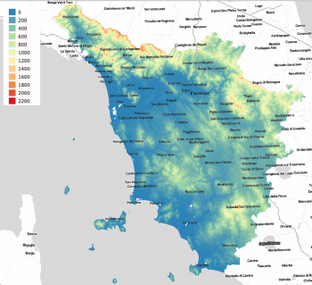
[[Image:ITA10_Tuscany.png|right|thumb|350px|Coverage for the DTM model for Tuscany – 10 m grid.]] | |||
== Introduction == | |||
The Italy/Tuscany 10m elevation model is a digital terrain model produced by the Tuscany Region through its Direzione Generale Governo del Territorio. The elevation data is in a 10m x 10m grid and have a spatial coverage for the whole of Tuscany. The model was produced from base maps in scale 1:10000 in years 1993-1998. | |||
== Usage Notes == | |||
Higher resolution data exists for selected areas in the region based on more recent LiDAR surveys: These 1m and 2 m gridded data may be accessed directly from the geodata-portal of Tuscany: http://www502.regione.toscana.it/geoscopio/cartoteca.html | |||
== Availability from within windPRO == | |||
The data are available directly from within windPRO in 10-meter resolution. The data can be accessed from the online-services in the following objects: | |||
* Line Object (with purpose to height contour lines) | |||
* Elevation Grid Object | |||
== Reference System == | |||
The following reference systems were used in the original data: | |||
* Gauss-Boaga Fuso Ovest (EPSG:3003) | |||
== License and Attribution == | |||
The product belongs to the open data of the region of Tuscany. The data are license under a under a Creative Commons Attribution 4.0 International License. Please use the following attribution when using this dataset: | |||
Contains elevation data from the Region of Tuscany 05/2019. Distribution through EMD and windPRO. | |||
== Acknowledgements == | |||
* The Region of Tuscany and its Direzione Generale Governo del Territorio are thanked for producing this digital elevation dataset – and disseminating it in the public domain and thus for aiding the development of renewable energy. | |||
* Integration of this dataset into EMD services - was co-supported through the InnoWind project (www.innowind.dk) - which is co-funded by the Danish Innovation Fund | |||
== External Links == | |||
* Geodata from the Tuscany Geoportal: http://www502.regione.toscana.it/geoscopio/cartoteca.html | |||
* InnoWind project - http://www.innowind.dk | |||
Revision as of 07:19, 3 June 2019

Introduction
The Italy/Tuscany 10m elevation model is a digital terrain model produced by the Tuscany Region through its Direzione Generale Governo del Territorio. The elevation data is in a 10m x 10m grid and have a spatial coverage for the whole of Tuscany. The model was produced from base maps in scale 1:10000 in years 1993-1998.
Usage Notes
Higher resolution data exists for selected areas in the region based on more recent LiDAR surveys: These 1m and 2 m gridded data may be accessed directly from the geodata-portal of Tuscany: http://www502.regione.toscana.it/geoscopio/cartoteca.html
Availability from within windPRO
The data are available directly from within windPRO in 10-meter resolution. The data can be accessed from the online-services in the following objects:
- Line Object (with purpose to height contour lines)
- Elevation Grid Object
Reference System
The following reference systems were used in the original data:
- Gauss-Boaga Fuso Ovest (EPSG:3003)
License and Attribution
The product belongs to the open data of the region of Tuscany. The data are license under a under a Creative Commons Attribution 4.0 International License. Please use the following attribution when using this dataset:
Contains elevation data from the Region of Tuscany 05/2019. Distribution through EMD and windPRO.
Acknowledgements
- The Region of Tuscany and its Direzione Generale Governo del Territorio are thanked for producing this digital elevation dataset – and disseminating it in the public domain and thus for aiding the development of renewable energy.
- Integration of this dataset into EMD services - was co-supported through the InnoWind project (www.innowind.dk) - which is co-funded by the Danish Innovation Fund
External Links
- Geodata from the Tuscany Geoportal: http://www502.regione.toscana.it/geoscopio/cartoteca.html
- InnoWind project - http://www.innowind.dk