European EMODnet Bathymetry: Difference between revisions
No edit summary |
No edit summary |
||
| Line 60: | Line 60: | ||
== Acknowledgement == | == Acknowledgement == | ||
* The European Marine Observation and Data Network (EMODnet) is thanked for producing this digital elevation dataset – and disseminating it in the public domain and thus for aiding the development of renewable energy. | * The European Marine Observation and Data Network (EMODnet) is thanked for producing this digital elevation dataset – and disseminating it in the public domain and thus for aiding the development of renewable energy. | ||
* Integration of | * Integration of this dataset into EMD services was co-supported through the InnoWind project (www.innowind.dk) which is co-funded by the Danish Innovation Fund | ||
== External Links == | == External Links == | ||
# Description of the EMODnet Bathymetry data set: http://www.emodnet-bathymetry.eu/data-products | # Description of the EMODnet Bathymetry data set: http://www.emodnet-bathymetry.eu/data-products | ||
# InnoWind project: http://www.innowind.dk | # InnoWind project: http://www.innowind.dk | ||
Revision as of 10:53, 17 January 2020


Introduction
For windPRO users working with offshore wind farm development, the "EMODnet Digital Bathymetry (DTM)" is a multilayer bathymetry dataset for Europe’s sea basins containing water depths. Two versions version exists:
- 2016: The 2016-version is based upon more than 7700 bathymetric survey data sets and composite DTMs that have been gathered from 27 data providers from 18 European countries. The 2016-DTM has a grid resolution of 1/8 * 1/8 arc minutes (roughly 230 * 230 meters).
- 2018: An updated version was released in 2018 with more data - now 9400 surveys from 49 data-providers - and with a higher resolution - now at 1/16 arc-minute (approximately 115 meters). The vertical reference level for the 2018-data in windPRO is the mean-sea-level (MSL).
Availability from within WindPRO and Usage Notes
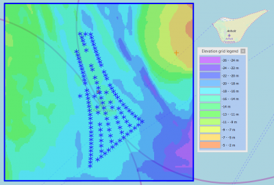
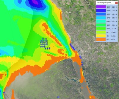
The data is available directly from within windPRO and can be accessed from the online-services in the Elevation Grid Object.
Usage:
- In order to access the data, please set the purpose of the Elevation Grid Object to 'Water depths'.
- If you want to export the grid to contour lines: This can be done from within the grid-object, simply select the layer of interest, then choose 'Export Layer'.
- Selected areas within the domain have higher resolution data available: These may be downloaded directly from the EMODnet portal.
Reference System
The following reference system was used in the original data:
- Geo [deg,min] - WGS84
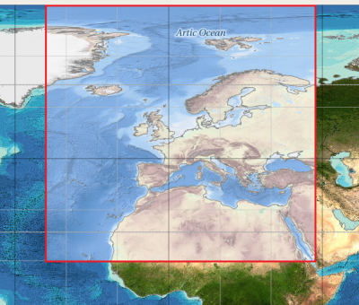
Coverage
- The Greater North Sea, including the Kattegat and stretches of water such as Fair Isle, Cromarty, Forth, Forties, Dover, Wight, and Portland
- The English Channel and Celtic Seas
- Western and Central Mediterranean Sea and Ionian Sea
- Bay of Biscay, Iberian coast and North-East Atlantic
- Adriatic Sea
- Aegean - Levantine Sea (Eastern Mediterranean)
- Azores - Madeira EEZ
- Canary Islands
- Baltic Sea
- Black Sea
- Norwegian – Icelandic seas
- European arctic region and Barentz sea
License and Attribution
As a part of the license conditions, users are requested to provide a reference to the EMODnet. So, please use the following attribution when using this dataset - and also consider and accept the disclaimer from EMODnet.
EMODnet Bathymetry Consortium (2018). EMODnet Digital Bathymetry (DTM 2018).
Distribution through windPRO and EMD.
https://doi.org/10.12770/18ff0d48-b203-4a65-94a9-5fd8b0ec35f6

EMODnet Bathymetry Consortium (2016): EMODnet Digital Bathymetry (DTM 2016).
Distribution through windPRO and EMD.
http://doi.org/10.12770/c7b53704-999d-4721-b1a3-04ec60c87238.
EMODnet Disclaimer
The EMODnet has provided a disclaimer for their DTM - see the text with italic below - or the disclaimer page at the data-portal.
Disclaimer - EMODnet Digital Terrain Model (DTM) for European seas
The EMODnet Digital Terrain Model (DTM) for European seas is not to be used for navigation or for any other purpose relating to safety at sea.
The EMODnet DTM 2016 has been created at a resolution of 1/8 arc-minutes and the 2018 version at a resolution of 1/16 arc minutes using the best available bathymetry from a variety of sources using a variety of methods. The data coverage is still incomplete and some data were collected several years ago, however as new data and other composite dtm datasets are made available, the gaps will be filled and the grid updated.
The information contained in the grid is believed to be trustworthy. However, its accuracy and completeness cannot be guaranteed. Whilst every effort has been made to ensure its reliability within the limits of present knowledge, no responsibility can be accepted by those involved in its compilation or publication for any consequential loss or damage arising from its use.
Acknowledgement
- The European Marine Observation and Data Network (EMODnet) is thanked for producing this digital elevation dataset – and disseminating it in the public domain and thus for aiding the development of renewable energy.
- Integration of this dataset into EMD services was co-supported through the InnoWind project (www.innowind.dk) which is co-funded by the Danish Innovation Fund
External Links
- Description of the EMODnet Bathymetry data set: http://www.emodnet-bathymetry.eu/data-products
- InnoWind project: http://www.innowind.dk