Italian Elevation Model - TINITALY: Difference between revisions
m (→Introduction) |
|||
| Line 2: | Line 2: | ||
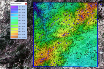
[[Image:ITA.png|right|thumb|350px|The DTM model for Italy – 10 m grid and 25 m contour lines - seen with the XX wind turbines at xx wind farm. The model shown covers an area of 10km x 10km.]] | [[Image:ITA.png|right|thumb|350px|The DTM model for Italy – 10 m grid and 25 m contour lines - seen with the XX wind turbines at xx wind farm. The model shown covers an area of 10km x 10km.]] | ||
== Introduction == | == Introduction == | ||
The Italian Elevation Model - TINITALY - is a seamless digital elevation model that covers the territory of Italy. It is procuced by Tarquini et al | The Italian Elevation Model - TINITALY - is a seamless digital elevation model that covers the territory of Italy. It is procuced by Tarquini et al - using a Triangular Irregular Network (TIN) approach - the model was first presented in 2007. The model is built from separate elevation models from each of the administrative regions of Italy, please consult (Tarquini, 2007) for further details on data sources. Grid resolution is 10m. This model is released from the National Institute of Geophysics and Volcanology / Istituto Nazionale di Geofisica e Vulcanologia (INGV). As a part of the TINITALY dataset evaluations by Tarquini and Nannipieri in 2017, the authors reported the TINITALY DEM to outperform other sources, see the quote below and consult the references for further details. | ||
<br><br>''"The TINITALY DEM is currently the DEM having the highest resolution and the lowest error (on average) covering the whole Italian territory.... and it represents, at a country or (trans-)regional scale, a substantial step forward with respect to global DEMs such as the ASTER DEM and the SRTM DEM..."''. | |||
=== Dataset Overview === | === Dataset Overview === | ||
Revision as of 09:30, 25 September 2020

Introduction
The Italian Elevation Model - TINITALY - is a seamless digital elevation model that covers the territory of Italy. It is procuced by Tarquini et al - using a Triangular Irregular Network (TIN) approach - the model was first presented in 2007. The model is built from separate elevation models from each of the administrative regions of Italy, please consult (Tarquini, 2007) for further details on data sources. Grid resolution is 10m. This model is released from the National Institute of Geophysics and Volcanology / Istituto Nazionale di Geofisica e Vulcanologia (INGV). As a part of the TINITALY dataset evaluations by Tarquini and Nannipieri in 2017, the authors reported the TINITALY DEM to outperform other sources, see the quote below and consult the references for further details.
"The TINITALY DEM is currently the DEM having the highest resolution and the lowest error (on average) covering the whole Italian territory.... and it represents, at a country or (trans-)regional scale, a substantial step forward with respect to global DEMs such as the ASTER DEM and the SRTM DEM...".
Dataset Overview
- Spatial Coverage: Italian territory
- Resolution: 10 m grid
- Data-type: Digital Terrain Model (DTM) - based on multiple local data sources (see below)
- Coordinate system: UTM WGS84 - zone 32 (EPSG 32632) in original data
- Version: Data downloaded in September 2020.
- Vertical Accuracy (RMSE):
- In general: TINITALY: <3.5m vs SRTM: 16m and Aster: 7m-50m for ASTER (see Tarquini, 2007 and 2011)
- At Mount Etna: TINITALY: 1.98m vs SRTM: 7.78m and Aster: 9.36m - comparison against LIDAR grount truth (see Tarquini, 2011)
- No data value: -9999 (in original data)
Usage Notes
- In the original TINITALY data, some zero-elevation grid points were present at data-tiles located in the mountaneous regions to the north. Typically they were found in proximity to the border or just outside the Italian territory. These erroneous values have been removed and are replaced with void-values by EMD.
Availability from within WindPRO
The data are available directly from within windPRO in 10-meter grid resolution. The data can be accessed from the online-services in the following objects:
- Line Object (with purpose to height contour lines)
- Elevation Grid Object
License and Attribution
TINITALY is published with a CC-BY-4.0 license. Please use the following attribution when using this dataset:
Tarquini S., Isola I., Favalli M., Battistini A. (2007) TINITALY, a digital elevation model of Italy with a 10 m-cell size (Version 1.0) [Data set].
Istituto Nazionale di Geofisica e Vulcanologia (INGV). https://doi.org/10.13127/TINITALY/1.0.
Data processing and distribution through EMD and windPRO.
Documentation / Litterature
A preprint of their paper is available here.
Acknowledgement
- Tarquini S., Isola I., Favalli M., Battistini A. and the National Institute of Geophysics and Volcanology are thanked for producing this digital elevation dataset – and disseminating it in the public domain and thus for aiding the development of renewable energy.
External Links
- National Institute of Geophysics and Volcanology / Istitutoi Nazionale di Geofisica e Vulcanologia (INGV): http://www.ingv.it/it/
- TINITALY: http://tinitaly.pi.ingv.it/