French Elevation Models: Difference between revisions
| Line 78: | Line 78: | ||
== Usage Notes == | == Usage Notes == | ||
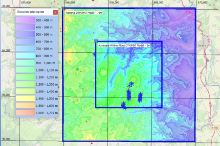
* Resolution: Please consider that the 5m or 10m grid data are at a quite high resolution - so processing and downloading large areas may be slow. We recommend that you use highest resolution data in a limited area around the site (say with a boundary of a few kilometers), then merge your elevation model with coarser resolution data. This is done very easily in the 'elevation grid object'. | * Resolution: Please consider that the 5m or 10m grid data are at a quite high resolution - so processing and downloading large areas may be slow. We recommend that you use highest resolution data in a limited area around the site (say with a boundary of a few kilometers), then merge your elevation model with coarser resolution data. This is done very easily in the 'elevation grid object'. | ||
* | * Versions: Data in windPRO were accessed, downloaded and adapted for windPRO distribution during spring 2019 and spring 2021. | ||
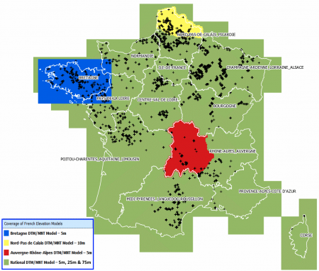
* Auvergne-Rhône-Alpes DTM/MNT Model – 5m: Elevation from five departments are available: Puy-de-Dôme, Cantal, Loire, Haute-Loire and Allier. Data is from 2016. | |||
== Availability from within windPRO == | == Availability from within windPRO == | ||
Revision as of 17:55, 18 March 2021


Introduction
From april/may 2021 the French elevation models have been updated with 5m data covering France and its overseas terriories: These digital terrain models DTM’s (MNT - Modèle Numérique de Terrain) are available with windPRO – three covering the whole of France in 5m, 25m and 75m grid resolution – and others from 3 selected administrative regions in high resolution: 5m grid or 10m grid resolutions. Elevation models from the French overseas territories are also available in 5m and 25m grid resolutions, see the table below. These French DTM datasets are freely available for windPRO users with an active subscription. The following French elevation models are available from spring 2021. Please note that it is also reported which grid resolutions are available within windPRO and which vertical references are used:
| Id | Coverage Area | Name | Resolutions | Vertical reference |
| 1 | France Mainland and Corsica | France MNT: IGN RGE ALTI(R) Version 2.0 - Metropolitan and Corsica | 5m, 25m, 75m | France: IGN69, tide gauge Marseille Corsica: IGN78, tide gauge Ajaccio |
| 2 | Mayotte Overseas Département | France MNT: IGN RGE ALTI(R) Version 2.0 - Mayotte | 5m, 25m | REUN89 |
| 3 | Réunion Overseas Département | France MNT: IGN RGE ALTI(R) Version 2.0 - Réunion | 5m, 25m | MAYO53 |
| 4 | Saint Pierre and Miquelon Overseas Département | France MNT: IGN RGE ALTI(R) Version 2.0 - Saint Pierre and Miquelon | 5m, 25m | STPM50 |
| 4 | Guadeloupe, Martinique, Saint-Barthélemy & Saint-Martin | France MNT: IGN RGE ALTI(R) Version 2.0 - Martinique, Saint-Barthélemy & Saint-Martin | 5m, 25m | STPM50 |
| 5 | French Guiana | France MNT: IGN RGE ALTI(R) Version 2.0 - French Guiana | 25m | |
| 6 | Auvergne-Rhône-Alpes | Auvergne-Rhône-Alpes DTM/MNT Model | 5m |
1. National DTM/MNT Model – 5m, 25m, 75m:
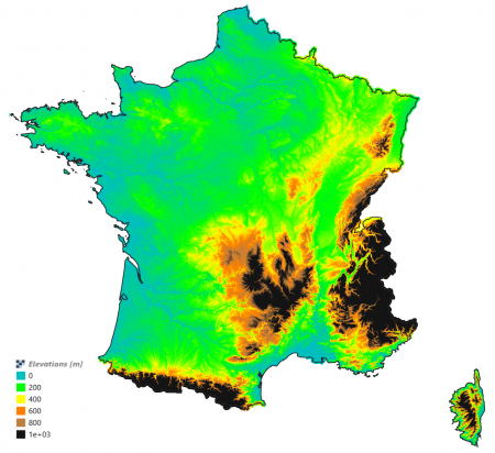
These model is the version of the national elevation model of France (BD Alti). The model is released from the Institut National de l’Information Geographique et Forestiére (IGN). It is based on digitization of maps and stereo-imagery with data from years 1987-2001. Higher resolution models can be purchased from the IGN. Read more on BD Alti in this pdf-document (in French).
3. Bretagne DTM/MNT Model – 5m:
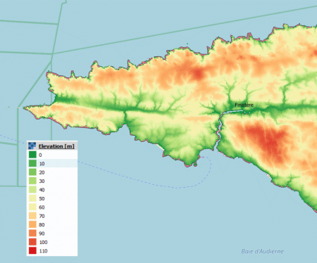
Elevation model in 5m resolution – with data obtained in the following years: Morbihan (2016), lle et Vilaine (2017), Côtes d'Armor (2015), Finistère (2015).
4. Nord-Pas de Calais DTM/MNT Model – 10m:
Model was derived from stereo-imagery during years 2012-2013.
Dataset Overview
- Spatial Coverage: France (75m) and 3 regions (5m and 10m)
- Resolution: Area-dependent: 5m, 10m, 75m
- Data-type: Digital Terrain Model (DTM)
- Coordinate system: Horizontal: RGF93 / Lambert-93 (EPSG:2154)
- Version: Data downloaded in spring 2019.
- Vertical Accuracy: N/A
Usage Notes
- Resolution: Please consider that the 5m or 10m grid data are at a quite high resolution - so processing and downloading large areas may be slow. We recommend that you use highest resolution data in a limited area around the site (say with a boundary of a few kilometers), then merge your elevation model with coarser resolution data. This is done very easily in the 'elevation grid object'.
- Versions: Data in windPRO were accessed, downloaded and adapted for windPRO distribution during spring 2019 and spring 2021.
- Auvergne-Rhône-Alpes DTM/MNT Model – 5m: Elevation from five departments are available: Puy-de-Dôme, Cantal, Loire, Haute-Loire and Allier. Data is from 2016.
Availability from within windPRO
The data are available directly from within windPRO and may be accessed from the online-services from the following objects:
- Line Object (with purpose to height contour lines)
- Elevation Grid Object
Please note that for the 5-meter grid data - the downloaded area is limited to 20 km x 20 km to keep the files at a usable size. The data within the elevation object may be extended with coarser data if a bigger area is needed.
Attributions
These products belong to the open data of France. Please use the following attributions when using one of the datasets:
- French National DTM/MNT Model – 75m: Contains elevation data from the Institut National de l’Information Geographique et Forestiére (IGN) – 05/2019. Distribution through EMD and windPRO.
- France - Auvergne-Rhône-Alpes DTM/MNT Model – 5m: Contains elevation data from the Centre Régional Auvergne-Rhône-Alpes de l'Information Géographique (CRAIG) – 05/2019. Distribution through EMD and windPRO.
- France - Bretagne DTM/MNT Model – 5m: Contains elevation data from GéoBretagne – 05/2019. Distribution through EMD and windPRO.
- France – Nord-Pas de Calais – 10m: Contains elevation data from the Plateforme Publique de l'Information Géographique de la Région Nord - Pas de Calais (PPIGE) – 05/2019. Distribution through EMD and windPRO.
Acknowledgements
- The French public, state (with IGN as its representative) and regions of Auvergne-Rhône-Alpes, Bretagne and Nord-Pas de Calais are thanked for producing these digital elevation datasets and disseminating them with an open-data licence - and thus aiding the development of renewable energy – and wind energy in particular.
- Integration of this dataset into EMD services was co-supported through the InnoWind project (www.innowind.dk) which is co-funded by the Danish Innovation Fund
License
Unless otherwise stated, these data have been released under the French License Ouverte / Open License – a license used for open data from the State of France. The license is designed to be compatible to be compatible with Creative Commons Licenses, Open Government License (UK) and the Open Data Commons Attribution License read pdf here. It is required that the source of information is mentioned when using these data – see above.
External Links
- Institut National de l’Information Geographique et Forestiére (IGN): http://professionnels.ign.fr
- Centre Régional Auvergne-Rhône-Alpes de l'Information Géographique (CRAIG): https://www.craig.fr/
- Le partenariat GéoBretagne: https://cms.geobretagne.fr
- Equipe PPIGE Plateforme Publique de l'Information Géographique - Nord-Pas de Calais: https://www.ppige-npdc.fr/portail/geocatalogue