Switzerland Elevation Model: Difference between revisions
m (→Introduction) |
mNo edit summary |
||
| Line 4: | Line 4: | ||
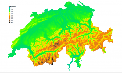
[[Image:SwissDGM_Elevations.png|right|thumb|400px|Swiss DTM. Image showing elevations from the 20m grid model. Data source: Bundesamt für Landestopografie swisstopo]] | [[Image:SwissDGM_Elevations.png|right|thumb|400px|Swiss DTM. Image showing elevations from the 20m grid model. Data source: Bundesamt für Landestopografie swisstopo]] | ||
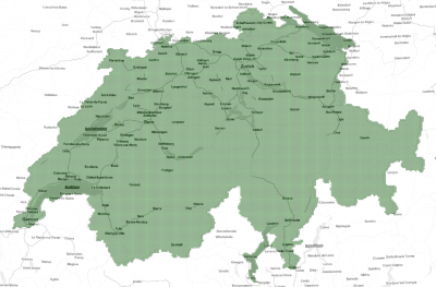
[[File:SwissDGM_Coverage.png|right|thumb|400px|Coverage of the Swiss DTM - here shown as polygons for the about 40000 tiles each 1km x 1km forming the DTM.]] | [[File:SwissDGM_Coverage.png|right|thumb|400px|Coverage of the Swiss DTM - here shown as polygons for the about 40000 tiles each 1km x 1km forming the DTM.]] | ||
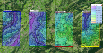
[[File:SwissElevations_At_Entlebuch_1800x940.png|right|thumb|400px|Image: 3 different elevation models (SwissALTI3D, CopernicusDEM and NASADEM) and 2 wind turbines close to Entlebuch, Switzerland.]] | |||
== Introduction == | == Introduction == | ||
The Switzerland Elevation Model (SwissALTI3D) is a digital terrain model (Digitales Geländemodell, DGM) produced by SwissTopo - the Swiss Bundesamt for Landestopografie. The dataset is an accurate digital terrain model developed as a part of a 6-year data-collection process - and being build from airborne laser-scans and stereo-imagery. Two Swiss elevation models are delivered with windPRO: one at 5m resolution and one at 20m resolution. The original models are available at maximum resolution of 0.5m and 2m, however, the highest resolution model in windPRO version is resampled by EMD to obtain a slightly coarser resolution - 5m. This is done in order for the data to be operational for the larger domains needed in the context of wind farm analysis and wind flow modelling. The resampling is made based on 2m data using a bi-linear interpolation algorithm. Data made available by EMD represents the data status of October 2021. | The Switzerland Elevation Model (SwissALTI3D) is a digital terrain model (Digitales Geländemodell, DGM) produced by SwissTopo - the Swiss Bundesamt for Landestopografie. The dataset is an accurate digital terrain model developed as a part of a 6-year data-collection process - and being build from airborne laser-scans and stereo-imagery. Two Swiss elevation models are delivered with windPRO: one at 5m resolution and one at 20m resolution. The original models are available at maximum resolution of 0.5m and 2m, however, the highest resolution model in windPRO version is resampled by EMD to obtain a slightly coarser resolution - 5m. This is done in order for the data to be operational for the larger domains needed in the context of wind farm analysis and wind flow modelling. The resampling is made based on 2m data using a bi-linear interpolation algorithm. Data made available by EMD represents the data status of October 2021. | ||
Revision as of 13:15, 7 October 2021
NOTE: This dataset is currently being integrated into windPRO.


Introduction
The Switzerland Elevation Model (SwissALTI3D) is a digital terrain model (Digitales Geländemodell, DGM) produced by SwissTopo - the Swiss Bundesamt for Landestopografie. The dataset is an accurate digital terrain model developed as a part of a 6-year data-collection process - and being build from airborne laser-scans and stereo-imagery. Two Swiss elevation models are delivered with windPRO: one at 5m resolution and one at 20m resolution. The original models are available at maximum resolution of 0.5m and 2m, however, the highest resolution model in windPRO version is resampled by EMD to obtain a slightly coarser resolution - 5m. This is done in order for the data to be operational for the larger domains needed in the context of wind farm analysis and wind flow modelling. The resampling is made based on 2m data using a bi-linear interpolation algorithm. Data made available by EMD represents the data status of October 2021.
Dataset Overview
- Spatial Coverage: Switzerland
- Resolution: 5m and 20 m in windPRO (original data in 0.5m and 2.0m grid resolution)
- Data-type: Digital Terrain Model (DTM)
- Coordinate system: Swiss coordinate system (LV95 LN02) - EPSG 2056
- Version: Data downloaded in October 2021
- Accuracy:
- The accuracy depends on the data-source. The following statement on accuracy is given as a one-sigma estimate for all 3 dimensions (see more at the links below):
- LiDAR: Newest data: 0.3m, Other data (below 2000m agl): 0.5m
- Elevations derived from stereo-correlation (above 2000m agl): 1.0m - 3.0m
- Manually corrected data (single points, edge-lines and areas): 0.1m - 1.0m
- The accuracy depends on the data-source. The following statement on accuracy is given as a one-sigma estimate for all 3 dimensions (see more at the links below):
Availability from within WindPRO
The data are available directly from within windPRO in 5m and 20-meter grid resolution. The data can be accessed from the online-services in the following objects:
- Line Object (with purpose to height contour lines)
- Elevation Grid Object
License and Attribution
The product belongs to the open geo-data of Switzerland. The data have been licensed under a national open data policy based on the following legal framework:
- Bundesgesetz über Geoinformation (Geoinformationsgesetz GeoIG SR 510.62) Art. 10 ff
- Verordnung über Geoinformation (Geoinformationsverordnung GeoIV SR 510.620) Art. 20 ff
- Verordnung des VBS über die Gebühren des Bundesamtes für Landestopografie (GebVswisstopo SR 510.620.2)
Please read and accept the usage-conditions before use - and be aware a proper attribution is required when using this dataset, such as:
Source:
 - Bundesamt für Landestopografie swisstopo
 - Office fédéral de topographie swisstopo
 - Ufficio federale di topografia swisstopo
 - Uffizi federal da topografia swisstopo
 - Federal Office of Topography swisstopo
 - ©swisstopo
Distribution through EMD and windPRO.
Link to the usage-conditions (accessed 2021-10-05):
- Usage conditions (Nutzungsbedingungen, German Language) - HERE.
- General usage conditions (Allgemeine Nutzungsbedingungen und Betriebsbestimmungen, German Language) - HERE.
Acknowledgement
- The SwissTopo and the Swiss public are thanked for producing this digital elevation dataset – and disseminating it in the public domain and thus for aiding the development of renewable energy.