Bing Aerial Maps: Difference between revisions
Jump to navigation
Jump to search
m (→Usage Notes) |
m (typo) |
||
| Line 6: | Line 6: | ||
* The Microsoft Bing Aerial Maps are provided with '''windPRO 4.0 as an experimental feature.''' | * The Microsoft Bing Aerial Maps are provided with '''windPRO 4.0 as an experimental feature.''' | ||
* For information about map updates, please consult the [https://blogs.bing.com/maps/ Bing Maps blog]. | * For information about map updates, please consult the [https://blogs.bing.com/maps/ Bing Maps blog]. | ||
* Billing of the Bing Aerial Maps in | * Billing of the Bing Aerial Maps in windPRO is covered as part of your windPRO service subscription - as long as your usage is compliant with the "Microsoft Bing Maps Services - terms of use and licenses" (see below) | ||
== Availability from within windPRO == | == Availability from within windPRO == | ||
Latest revision as of 09:40, 8 March 2024


Introduction
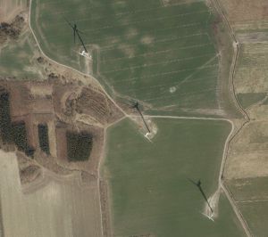
Bing Aerial Maps in windPRO provides amazing, high-resolution aerial imagery for most parts of the world. Coverage varies by area, country, and region. The Bing Maps team continuously updates this aerial imagery dataset.
Usage Notes
- The Microsoft Bing Aerial Maps are provided with windPRO 4.0 as an experimental feature.
- For information about map updates, please consult the Bing Maps blog.
- Billing of the Bing Aerial Maps in windPRO is covered as part of your windPRO service subscription - as long as your usage is compliant with the "Microsoft Bing Maps Services - terms of use and licenses" (see below)
Availability from within windPRO
- From map window: Click the ‘Add map’ globe-icon -> then ‘Dynamic Maps’.
- From main menu: Click ‘Project’ -> ‘Properties’ -> ‘Background Maps’ -> ‘Dynamic Maps’ -> 'Bing Aerial Maps'
License and Attribution
Use of this layer and maps created with it implies agreement with the terms and conditions of the Microsoft Bing Maps Services License here and here. EMD holds a "Developer License" that covers use of bing-maps within windPRO, with map-access implemented through the Bing Maps Platform API.
Acknowledgement
- A big thank you goes to the Microsoft Bing Maps team and its data providers - for producing this amazing digital dataset: It surely helps us in the development of renewable energy projects.