EMD Electrical Grid Map: Difference between revisions
(→Legend) |
|||
| Line 10: | Line 10: | ||
Samples of two selected places in Denmark and Austria are shown in the figure below. | Samples of two selected places in Denmark and Austria are shown in the figure below. | ||
[[File: | [[File:EmdElectricalGrid|center|thumb|800px|Samples of EMD Electrical Grid Map (left: Part of Aalborg, Denmark, right: Part of Vienna, Austria)<br>© OpenStreetMap contributors]] | ||
== Legend == | == Legend == | ||
Revision as of 13:21, 26 November 2024
Introduction
Open Street Map (OSM) is an open and editable map. It has a global coverage, and is created and edited by a community effort.
Please visit the OSM project homepage (http://www.openstreetmap.org) in order to learn more and also how to contribute to build an even better map.
The EMD Electrical Grid Map, is based on the Open Street Map project, but focuses on the electrical grid data. This is done by dulling normal map colors, and draw elements from the electrical grid on top of the map.
Samples of two selected places in Denmark and Austria are shown in the figure below.
© OpenStreetMap contributors
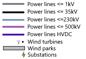
Legend
Power lines are split into 5 categories, shown at different zoom levels:
- Up to 1kV: Shown from zoom level 11 in dark grey
- Up to 35kV: Show from zoom level 11 in light green
- Up to 230kV: Shown from zoom level 5 in light purple
- Up to 500kW: Shown from zoom level 5 in dark purple
- High voltage DC: Shown from zoom level 5 in dark blue
Power cables under ground/water is drawn dashed.
- Substations are shown from zoom level 8 as a lightning symbol
- Wind Turbine parks are shown from zoom level 8 as a light grey polygon
- Individual turbines are shown a dots from zoom level 8 and as a turbine symbol from zoom level 12

© OpenStreetMap contributors
Usage Notes
- Issue with mapping of disputed territories around the world (1):
EMD policies on the OSM dynamic map in windPRO is aligned with official OSM policies. Citation from OSM-website: "Currently, we record one set that, in OpenStreetMap contributor opinion, is most widely internationally recognised and best meets realities on the ground, generally meaning physical control. In areas without clearly defined borders, the line is approximate." Learn more at the OSM wiki: https://wiki.openstreetmap.org/wiki/Disputed_territories. - Issue with mapping of disputed territories around the world (2):
If it is not feasable for you to use the OSM-map based on actual in-situ conditons, such as if you need to use a map with your official national (claimed) borders or the interntional recognized borders: In this situation, we recommend to procure an official map from your national ordnance-survey or preferred map-provider. Then attach this map as a background map to windPRO. In windPRO it is very easy to add georefernced images and map-servers: see how in the BASIS manual (section 2.4, this is available from the windPRO knowledgebase).
Data License
OpenStreetMap is open data, licensed under the Open Data Commons Open Database License (ODbL). The full license text is available from http://www.openstreetmap.org/copyright. You are free to copy, distribute, transmit and adapt our data, as long as you credit OpenStreetMap and its contributors.
Credits
OpenStreetMap require that you use the credit “© OpenStreetMap contributors”. Please remember to add this text when using EMD Electrical Grid Map.