UK-Land-Form PANORAMA: Difference between revisions
No edit summary |
No edit summary |
||
| Line 1: | Line 1: | ||
[[Category: Online Data]][[Category: Digital Elevation Models]] | [[Category: Online Data]][[Category: Digital Elevation Models]] | ||
== Introduction == | == Introduction == | ||
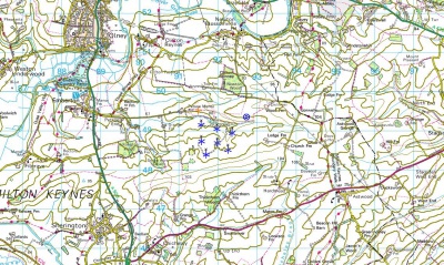
[[File:LandFormPANORAMA.jpg|right|400px|thumb|Land-Form PANORAMA data shown at the Milton Keynes Wind Farm. Picture contains Ordnance Survey data © Crown copyright and database right 2013]]Land-Form PANORAMA is a digital elevation dataset for Great Britain: Two versions of the dataset exist: one vector-dataset that provides height contours with a 10 m vertical spacing and one gridded dataset with a grid-spacing of 50 m. The resolution of the dataset corresponds to a 1:50000 mapping. Please note that the dataset is unmaintained. | [[File:LandFormPANORAMA.jpg|right|400px|thumb|Land-Form PANORAMA data shown at the Milton Keynes Wind Farm. Picture contains Ordnance Survey data © Crown copyright and database right 2013 Ordnance Survey]]Land-Form PANORAMA is a digital elevation dataset for Great Britain: Two versions of the dataset exist: one vector-dataset that provides height contours with a 10 m vertical spacing and one gridded dataset with a grid-spacing of 50 m. The resolution of the dataset corresponds to a 1:50000 mapping. Please note that the dataset is unmaintained. | ||
== Coverage == | == Coverage == | ||
| Line 16: | Line 16: | ||
The data is distributed according to the [http://help.emd.dk/mediawiki/images/e/e5/OsOpenDataTerms.pdf OS OpenData terms] . Please take proper care to add proper atribution in order to acknowledge the source of information. Typically, this is done by adding the following statement to your report-picture or map: | The data is distributed according to the [http://help.emd.dk/mediawiki/images/e/e5/OsOpenDataTerms.pdf OS OpenData terms] . Please take proper care to add proper atribution in order to acknowledge the source of information. Typically, this is done by adding the following statement to your report-picture or map: | ||
Contains Ordnance Survey data © Crown copyright and database right [year] | Contains Ordnance Survey data © Crown copyright and database right [year] Ordnance Survey | ||
== Raw Data Types == | == Raw Data Types == | ||
Revision as of 13:44, 6 June 2013
Introduction

Land-Form PANORAMA is a digital elevation dataset for Great Britain: Two versions of the dataset exist: one vector-dataset that provides height contours with a 10 m vertical spacing and one gridded dataset with a grid-spacing of 50 m. The resolution of the dataset corresponds to a 1:50000 mapping. Please note that the dataset is unmaintained.
Coverage
This dataset covers the whole of Great Britain (not including Northern Ireland).
Availability in WindPRO
The data is available from the WindPRO online services. The data can be accessed from the online-services in the following objects:
- Line Object (with purpose to height contour lines)
- Elevation Grid Object
Licence and Acknowledgement
The data is distributed according to the OS OpenData terms . Please take proper care to add proper atribution in order to acknowledge the source of information. Typically, this is done by adding the following statement to your report-picture or map:
Contains Ordnance Survey data © Crown copyright and database right [year] Ordnance Survey
Raw Data Types
- Raw vector data is stored in the DXF-format.
- Grid data is stored in either ASCII-Grid or NTF-format.
External Links
- Original data is available from the web-page of the Ordnance Survey http://www.ordnancesurvey.co.uk/oswebsite/products/land-form-panorama/index.html.
- OS OpenData Terms / Licence is available here: http://www.ordnancesurvey.co.uk/oswebsite/docs/licences/os-opendata-licence.pdf.