Swedish SLU Forest Map

Introduction
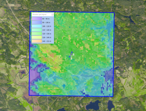
The Swedish University of Agricultural Sciences (SLU) is developing and updating a forest map with Swedish National coverage. The map is developed using a ‘k nearest neighbors’ method driven by data obtained from a combination of LANDSAT and SPOT satellite images along with field data from the Swedish National Forest Inventory. The map holds a spatial coverage for the most of Sweden – with a grid resolution of 25m. In WindPRO we use the forest height data, but the original dataset also holds information about forest age, species and standing volume. Currently (2018), forest maps are available for years 2010, 2005 and 2000. In windPRO we distribute the latest version from 2010.
A Note on Usage: SLU states that the map primarily intended for use with larger areas of forest, so if the area is less than a few hundred hectares then the information should be used with a degree of caution.
Availability from within WindPRO
The data are available directly from within windPRO in 25 meter resolution. The data can be accessed from the online-services in the 'Elevation Grid Object' in the following way.
- Open the 'Elevation Grid Object'.
- Select ‘Data type’ to ‘Heights above terrain (a.g.l) for “elements”.
- Click ‘Add Layer from Online Data‘.
Data Type and Use in windPRO
The Swedish SLU Forest Map are delivered as gridded data with a spatial resolution of 25 meters. It holds the tree height data as of 2010. The data is used for forest modelling - and is very helpful in for establishing the displacement heights as well as the added roughness for the Objective Roughness Approach (ORA) model.
Coverage
This dataset covers Sweden.
License
External Links
- More information on the SLU Forest Map: Available at https://www.slu.se/en/Collaborative-Centres-and-Projects/the-swedish-national-forest-inventory/forest-statistics/slu-forest-map/
Acknowledgement
The Swedish University of Agricultural Sciences, Department of Forest Resource Management, Swedish University of Agricultural Sciences are acknowledged for development and release of the free and open dataset of forest heights.