Copernicus Global Land Service - Land Cover 100m
Introduction


The CGLS-LC100 is a dynamic land cover map at 100m resolution and a part of the product portfolio for the Copernicus Global Land Service (CGLS) see [1]. It has the target to deliver a yearly, global land cover map which primarily will be based based on PROBA-V – and later to be merged and replaced by Sentinel-2 satellite sources. Currently (2020), a dataset with near global coverage has been released with a 100m grid resolution. The map represents 2015 land cover and was derived from PROBA-V time series combined with local land cover training datasets as well as ancillary datasets.
Dataset Overview
- Spatial Coverage: Global
- Resolution: 100 m.
- Data Type: Land Cover / Land Use Mapping - with roughness length mapping by EMD (lookup table)
- Versions:
- 2015: Current version in windpro
- 2015 (Africa-demo): Preliminary dataset for Africa (now discontinued)
- Themaric Accuracy: 80.1% +/-0.7% (see User manual, [2])
- Updates: A yearly release is planned.
Validation
The product user manual (version 1 from 2017) holds data from the product validation from the Africa demonstration dataset. Here a comparison against other available global land cover maps is reported. Based on data from 3887 reference points, the CGLS-LS100 data come out with the best overall agreement to the ‘ground truth’ data. The overall agreement is as follows:
| Dataset Name | Overall Agreement |
|---|---|
| GlobCover 2009 | 50.8% |
| LC-CCI 2010 | 55.5% |
| MODIS 2010 | 63.0% |
| Globeland 2010 | 57.2% |
| CGLS-LC100 | 66.0% |
Legends
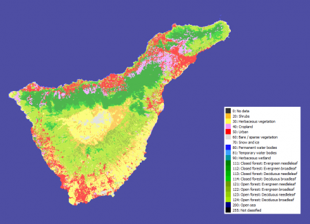
The legend is based on the UN LCCS (United Nations Land Cover Classification System).
For the CGLS-LS100 main land cover product, it holds 23 descreete classes, see the table below.
| ID | Land Cover Type | EMD Roughness Length | Definition UN LCSS |
|---|---|---|---|
| 0 | No data | z0=NA | NA |
| 20 | Shrubs | z0=0.070 | These are woody perennial plants with persistent and woody stems and without any defined main stem being less than 5 m tall. The shrub foliage can be either evergreen or deciduous. |
| 30 | Herbaceous vegetation | z0=0.500 | Plants without persistent stem or shoots above ground and lacking definite firm structure. Tree and shrub cover is less than 10%. |
| 40 | Cropland | z0=0.100 | Lands covered with temporary crops followed by harvest and a bare soil period (e.g., single and multiple cropping systems). Note that perennial woody crops will be classified as the appropriate forest or shrub land cover type. |
| 50 | Urban / built up | z0=0.400 | Land covered by buildings and other man-made structures. |
| 60 | Bare/sparse vegetation | z0=0.020 | Lands with exposed soil, sand, or rocks and never has more than 10% vegetated cover during any time of the year. |
| 70 | Snow and ice | z0=0.001 | Lands under snow or ice cover throughout the year. |
| 80 | Water bodies - permanent | z0=0.000 | Lakes, reservoirs, and rivers. Can be either fresh or salt-water bodies. |
| 90 | Wetland - herbaceous | z0=0.100 | Lands with a permanent mixture of water and herbaceous or woody vegetation. The vegetation can be present in either salt, brackish, or fresh water. |
| 100 | Moss and lichen | z0=0.0024 | Moss and lichen |
| 111 | Forest, closed, evergreen needle leaf | z0=0.500 | Tree canopy >70%, almost all needle leaf trees remain green all year. Canopy is never without green foliage. |
| 112 | Forest, closed, evergreen, broad leaf | z0=0.500 | Tree canopy >70%, almost all broadleaf trees remain green year round. Canopy is never without green foliage. |
| 113 | Forest, closed, deciduous, needle leaf | z0=0.500 | Tree canopy >70%, consists of seasonal needle leaf tree communities with an annual cycle of leaf-on and leaf-off periods |
| 114 | Forest, closed, deciduous, broad leaf | z0=0.500 | Tree canopy >70%, consists of seasonal broadleaf tree communities with an annual cycle of leaf-on and leaf-off periods |
| 115 | Closed forest, mixed | z0=0.50 | Closed forest, mix of types |
| 116 | Closed forest, unknown | z0=0.50 | Closed forest, not matching any of the other definitions |
| 121 | Forest, open, evergreen, needle leaf | z0=0.400 | Top layer- trees 15-70% and second layer- mixed of shrubs and grassland, almost all needle leaf trees remain green all year. Canopy is never without green foliage. |
| 122 | Forest, open, evergreen, broad leaf | z0=0.400 | Top layer- trees 15-70% and second layer- mixed of shrubs and grassland, almost all broadleaf trees remain green year round. Canopy is never without green foliage. |
| 123 | Forest, open, deciduous, needle leaf | z0=0.400 | Top layer- trees 15-70% and second layer- mixed of shrubs and grassland, consists of seasonal needle leaf tree communities with an annual cycle of leaf-on and leaf-off periods. |
| 124 | Forest, open, deciduous, broad leaf | z0=0.400 | Top layer- trees 15-70% and second layer- mixed of shrubs and grassland, consists of seasonal needle leaf tree communities with an annual cycle of leaf-on and leaf-off periods. |
| 125 | Open forest, mixed | z0=0.40 | Open forest, mix of types |
| 126 | Open forest, unknown | z0=0.40 | Open forest, not matching any of the other definition |
| 200 | Open Sea | z0=0.000 | Oceans, seas. Can be either fresh or salt-water bodies. |
| 255 | Not classified | z0=NA | NA |
Data License and Credits
Data from the Global Land Service is subjected to the free and open access policy from the European Union’s Copernicus Regulation (see here: https://www.copernicus.eu/en/how/how-access-data). Please make sure to use a proper attribution when using these CGLS-LC100 data, such as:
Source: Contains modified Copernicus Service information [2020].
This product was generated by the Global Land Service of Copernicus. It is based on PROBA-V data by ESA and distributed by VITO.
windPRO distribution and adaption by EMD International A/S.
For a complete acknowledgement and credit, the following statement can be used:
"The product was generated by the Global component of the Land Service of Copernicus, the Earth
Observation programme of the European Commission. The research leading to the current version
of the product has received funding from various European Commission Research and Technical
Development programs. The product is based on PROBA-V data provided by Belgian Science Policy
Office (BELSPO) and distributed by VITO. windPRO distribution and adaption by EMD International A/S."
Acknowledgement
- The European Commission and the Copernicus team are acknowledged for the development and release of the free and open Copernicus data.
- Integration of this dataset into EMD services was co-supported through the InnoWind project (www.innowind.dk) which is co-funded by the Danish Innovation Fund
References
- Copernicus Global Land Service, available at: https://land.copernicus.eu
- Copernicus Global Land Operations “Vegetation and Energy” – Product User Manual – Moderate Dynamic Land Cover 100m, Version I2.10, 2019-05-10
- Copernicus Global Land Operations “Vegetation and Energy” – Product User Manual – Moderate Dynamic Land Cover 100m, Version I1.00, 2017-09-28
- InnoWind project, http://www.innowind.dk