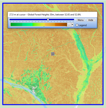
Near-Global Forest Canopy Heights GLAD

Introduction
The Near Global Forest Canopy Height (GLAD, 2019) is a dataset developed from a fusion of GEDI lidar data (Global Ecosystem Dynamics Investigation Lidar) and Landsat imagery data.
This dataset has a near global spatial coverage ranging from latitudes 52.6S to 52.6N.
Currently (2020) it is to be considered as a prototype map as both machine learning algorithms and available data are still being being improved.
The dataset was developed by the Global Land Analysis and Discovery (GLAD) laboratory in the Department of Geographical Sciences at the University of Maryland.
The data reflects the 95% relative height of the canopy. In the current version, tree heights beyond 30m are saturated by the model used.
Usage Notes
- Canopy heights above 30m height is underestimated as the model used saturated above 30 m: The height og the tallest trees are not adequately represented
- Map is still condisidered as a protopype - altorithms and data are being improved.
- GEDI data overestimate forest height on slopes within temperate and subtropical mountain grasslands
- Tree height over cities and suburbs may be confounded with building height
- Geolocation precision and land surface height estimation may be responsible for some map errors
Availability from within WindPRO
The forest height data is available directly from within windPRO in 30 meter resolution. The data can be accessed from the online-services in the 'Elevation Grid Object' in the following way.
- Open the 'Elevation Grid Object'.
- Select ‘Data type’ to ‘Heights above terrain (a.g.l) for “elements”.
- Click ‘Add Layer from Online Data‘.
Technical Details
Format: Geotiff
Pixel values: Canopy height 2019 (m)
Spatial resolution: 0.00025 degree (approximately 30m)
Geographical coverage: From 51.6S to 51.6N
Coordinate system: WGS84 geographic coordinates (in original data)
Pixel values:
0-60 - tree height in meters
101 Water, 102 Snow/ice, 103 no data
Null values:
32767 is a null value: the pixel does not belong to forestry land or canopy height is outside boundaries set (0.5m to 30m)
Coverage
This dataset nearly covers the world, ranging from latitudes 52.6S to 52.6N
License and Acknowledgement
The map is in the public domain. The Global Land Analysis and Discovery laboratory in the Department of Geographical Sciences at the University of Maryland has made the data available free of charge.
We recommend using the following attribution when using the data:
Source:
Global forest height data from the Global Land Analysis and Discovery laboratory in the Department of Geographical Sciences at the University of Maryland. Processing and distribution through EMD and windPRO. Public Domain.
References:
P. Potapov, X. Li, A. Hernandez-Serna, A. Tyukavina, M.C. Hansen, A. Kommareddy, A. Pickens, S. Turubanova, H. Tang, C. E. Silva, J. Armston, R. Dubayah, J. B. Blair, M. Hofton (2020): Global Forest Canopy Height (2019), https://glad.earthengine.app/view/global-forest-canopy-height-2019