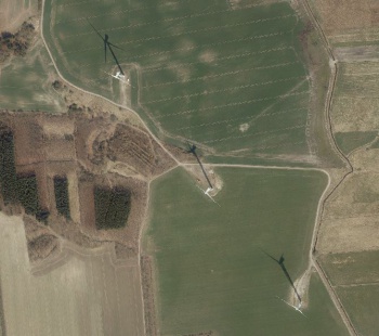
Danish Orthophoto Mosaic

Introduction
The Danish Orthophoto Mosaic is a part of the dynamic, zoomable maps in windPRO. The orthophotos were released by the Danich Geodata Agency and – in order to cover the entire Denmark - they come from multiple annual campaigns. Update frequency for the orthophotos is every year. The mosaic in windPRO is based on the most recent data available. Pixel size is ~0.50m.
Usage Notes
- The mosaic was created from available data sources accessed in Match 2019
- The most recent imagery is used to create the mosaic
Availability from within windPRO
- From map window: Click the ‘Add map’ globe-icon -> then ‘Dynamic Maps’.
- From main menu: Click ‘Project’ -> ‘Properties’ -> ‘Background Maps’ -> ‘Dynamic Maps’
License and Attribution
Contains data from the Danish Geodata Agency, Danish Springtime Orthophotos, 2019
Acknowledgement
- The Danish Geodata Agency are thanked for producing this digital dataset – and disseminating it in the public domain and thus for aiding the development of renewable energy.
- Integration of this dataset into EMD services - was co-supported through the InnoWind project (www.innowind.dk) - which is co-funded by the Danish Innovation Fund