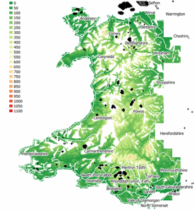
UK-Wales Elevation Model

Introduction
The UK - Wales Elevation model in 5m grid resolution is a digital terrain model (DTM) produced from higher resolution LiDAR scans originally obtained from the Natural Resources Wales. The original model at 2m resolution is named ‘LiDAR Composite Dataset – DTM – version 2m.’ The derived elevation model delivered with windPRO is at 5m resolution – and is bi-linearly resampled by EMD to obtain a slightly coarser resolution - 5m – this is done in order for the data to be operational for the large areas needed in the context of wind farm analysis’. Coverage for the data is approximately 70% of Wales territory.
Usage Notes
- Download and processing time is in minutes - so please be patient! Due to the large amounts of high-resolution elevation data and the tile-based storage system, you will experience that downloading the data for a site may last a few minutes. Please consider downloading 'smaller' areas (say 10km x 10km instead of 20km x 20km)
- Higher resolution data exist for selected areas in the region based on more recent LiDAR surveys: These are in resolutions from 0.25m to 2m – and may be accessed directly from the geodata-portal of Wales (see link below). More information about the Wales Lidar products can be found in the LiDAR Guidance document from the Natural Resources Wales.
Availability from within windPRO
The data are available directly from within windPRO in 5-meter grid resolution. The data can be accessed from the online-services in the following objects:
- Line Object (with purpose to height contour lines)
- Elevation Grid Object
Reference System
The following reference systems were used in the original data:
- Horizontal: OSGB36 British National Grid (EPSG: 27700)
- Vertical: Elevations recorded above Ordnance Datum Newlyn
License and Attribution
The product belongs to the open geospatial data of the Natural Resources Wales. The data are license under a under a ‘Open Government License for Public Sector Information’. This license is compatible with the Creative Commons Attribution License 4.0. Please use the following attribution when using this dataset:
- Source: Contains Natural Resources Wales Information ©. Natural Resources Wales and database right. Adapted and distributed by EMD and windPRO.
Acknowledgements
- The Welsh Government, Natural Resources Wales and the public of Wales are thanked for producing this digital elevation dataset – and disseminating it in the public domain and thus for aiding the development of renewable energy.
- Integration of this dataset into EMD services - was co-supported through the InnoWind project (www.innowind.dk) - which is co-funded by the Danish Innovation Fund
External Links
- Geodata from the Wales: http://lle.gov.wales/home
- InnoWind project - http://www.innowind.dk