Difference between revisions of "Category:Atlas Data"
Jump to navigation
Jump to search
m (→Introduction) |
m (→Introduction) |
||
| Line 1: | Line 1: | ||
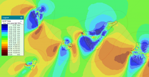
[[Image:GASP_CanaryIslands.png|500px|right|thumb|Illustration of Global Atlas of Site Parameters (GASP) within the windprospecting.com portal]] | [[Image:GASP_CanaryIslands.png|500px|right|thumb|Illustration of Global Atlas of Site Parameters (GASP) within the windprospecting.com portal]] | ||
== Introduction == | == Introduction == | ||
| − | Global and regional atlas datasets have been integrated into EMD software tools such as [http://www.windpro.com windPRO 3.5+], [http://www.windprospecting.com/ windPROSPECTING] and [https://api.emd.dk/ EMD-API]. The | + | Global and regional atlas datasets have been integrated into EMD software tools such as [http://www.windpro.com windPRO 3.5+], [http://www.windprospecting.com/ windPROSPECTING] and [https://api.emd.dk/ EMD-API]. |
| + | |||
| + | The atlas data allows users to make pre-feasibilty studies using pre-calculated atlas data sources - and to easily do a screening larger areas and to determine which locations are suitable for further analysis and potential development. | ||
== Let us know! == | == Let us know! == | ||
EMD and our development teasms continuously working to add better and higher quality dataset into our software tools like windPRO. We welcome suggestions for new and open datasets to integrated: Please submit any proposals at [https://tinyurl.com/new-windpro-dataset this feedback form]. | EMD and our development teasms continuously working to add better and higher quality dataset into our software tools like windPRO. We welcome suggestions for new and open datasets to integrated: Please submit any proposals at [https://tinyurl.com/new-windpro-dataset this feedback form]. | ||
Revision as of 11:50, 8 June 2021
Introduction
Global and regional atlas datasets have been integrated into EMD software tools such as windPRO 3.5+, windPROSPECTING and EMD-API.
The atlas data allows users to make pre-feasibilty studies using pre-calculated atlas data sources - and to easily do a screening larger areas and to determine which locations are suitable for further analysis and potential development.
Let us know!
EMD and our development teasms continuously working to add better and higher quality dataset into our software tools like windPRO. We welcome suggestions for new and open datasets to integrated: Please submit any proposals at this feedback form.
Pages in category "Atlas Data"
The following 2 pages are in this category, out of 2 total.
