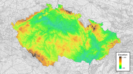
Czech Republic DTM
Note: This model is currently being integrated in windPRO.
Introduction
The Czech Republic elevation model is a digital terrain model (DTM) produced from airborne laser scanning (LIDAR) data obtained in years 2009-2014. The data in windPRO is sourced from Geoportal ČÚZK operated by the Czech Land Survey Office. The model in windPRO is derived from the INSPIRE compliant dataset - which again is derived from the Digital Terrain Model of the Czech Republic – 4th generation (DMR 4G). Coverage is the whole of the Czech Republic. In windPRO we deliver two DTM's, a fine-resoution model (5m grid) and a version resampled by EMD to obtain a slightly coarser resolution (20 m). This is in order for the data to be operational for the larger areas needed in the context of wind farm analysis’.
Dataset Overview
- Spatial Coverage: Czech Republic
- Resolution: 5 m and 20m
- Data-type: Digital Terrain Model (DTM)
- Coordinate system:
- Horizontal: ETRS89/UTM 33N (EPSG:3045)
- Vertical: EVREF2007 (EPSG:5621)
- Version: Data downloaded in December 2023.
- Vertical Accuracy: 0.3m in bare terrain and 1.0m in forested terrain (for DMR 4G dataset)
Usage Notes
- Please allow 1-2 minutes for windPRO to process and download the high-resolution data (5m grid resolution). This is due to the size and resolution of the dataset.
Availability from within WindPRO
The data are available directly from within windPRO in 5-meter and 20-meter grid resolutions. The data can be accessed from the online-services in the following objects:
- Line Object (with purpose to height contour lines)
- Elevation Grid Object
License and Attribution
The product is released following the Creative Commons By Attribution 4.0 license. When using the data, please acknowledge the source of information and use a proper attribution, such as:
Source:
Elevation data from the Land Survey Office of the Czech Republic (based on DMR 4G).
Adapted and distributed by EMD and windPRO.
Acknowledgement
- The Land Survey Office of the Czech Republic are thanked for producing this digital elevation dataset – and disseminating it in the public domain and thus for aiding the development of renewable energy.
