Dynamic maps: Difference between revisions
Jump to navigation
Jump to search
No edit summary |
No edit summary |
||
| Line 3: | Line 3: | ||
''Dynamic maps'' are downloaded on-the-fly in windPRO. This means you can zoom and pan around the map window like you do in e.g. Google Maps, Bing Maps. | ''Dynamic maps'' are downloaded on-the-fly in windPRO. This means you can zoom and pan around the map window like you do in e.g. Google Maps, Bing Maps. | ||
windPRO comes with the following | windPRO comes with the following dynamic maps: | ||
* [[WindPRO_Global_Satellite_Imagery| windPRO Global Satellite Imagery - 10m]] | * [[WindPRO_Global_Satellite_Imagery| windPRO Global Satellite Imagery - 10m]] | ||
* [[WindPRO_European_Satellite_Imagery| windPRO European Satellite Imagery - 2.5m]] | |||
* [[Open_Street_Map|EMD Open Street Map]] | * [[Open_Street_Map|EMD Open Street Map]] | ||
* Stamen Terrain from: [http://maps.stamen.com/#terrain/ maps.stamen.com] | * Stamen Terrain from: [http://maps.stamen.com/#terrain/ maps.stamen.com] | ||
* Open Topo Map from: [https://opentopomap.org/credits opentopomap.org] | * Open Topo Map from: [https://opentopomap.org/credits opentopomap.org] | ||
More datasets are expected to be added over time. Maps developed by EMD may be updated at any time. | More datasets are expected to be added over time. | ||
Maps developed by EMD may be updated at any time. | |||
Revision as of 12:04, 15 June 2018

Introduction
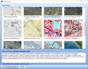
Dynamic maps are downloaded on-the-fly in windPRO. This means you can zoom and pan around the map window like you do in e.g. Google Maps, Bing Maps.
windPRO comes with the following dynamic maps:
- windPRO Global Satellite Imagery - 10m
- windPRO European Satellite Imagery - 2.5m
- EMD Open Street Map
- Stamen Terrain from: maps.stamen.com
- Open Topo Map from: opentopomap.org
More datasets are expected to be added over time. Maps developed by EMD may be updated at any time.