Viewfinder Panoramas: Difference between revisions
m (→Introduction) |
|||
| (41 intermediate revisions by 2 users not shown) | |||
| Line 1: | Line 1: | ||
[[Category: Online Data]][[Category: Digital Elevation Models]] | [[Category: Online Data]][[Category: Digital Elevation Models]] | ||
== Introduction == | == Introduction == | ||
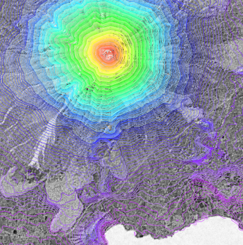
The Viewfinder Panoramas dataset is a digital elevation dataset with focus on the areas outside SRTM coverage. Also, the dataset has been focusing on fixing the voids in the SRTM dataset, e.g. by improving the DEM data in mountainous | [[File:ExampleSRTM.png|right|thumb|350px|Satellite Image with DEM Overlay. The image shows a part of the Ometepe Island in Lake Nicaragua with SRTM height contour data.]] | ||
The Viewfinder Panoramas dataset is a digital elevation dataset with focus on the areas outside SRTM coverage. Also, the dataset has been focusing on fixing the voids in the SRTM dataset, e.g. by improving the DEM data in mountainous terrain. The dataset is developed and maintained by Jonathan de Ferranti and published on his website [http://www.viewfinderpanoramas.org http://www.viewfinderpanoramas.org]. Please note: Johathan de Ferranti is continously updating and improving the data, so it might be worth giving his web-site a review if you find that data in WindPRO is missing. | |||
=== Dataset Overview === | |||
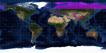
* '''Spatial Coverage:''' Outside SRTM coverage and areas where SRTM has voids (see image to the right). | |||
* '''Resolution:''' 3 arc-second (approximately 90m) | |||
* '''Data-type:''' [[:Category%3ADigital_Elevation_Models#What_type_of_elevation_model.3F_DEM.2C_DSM_and_DTM.3F|Digital Surface Model (DSM)]] | |||
* '''Coordinate system (horizontal):''' Geographic WGS (EPSG:4326) | |||
* '''Version:''' N/A | |||
* '''Vertical Accuracy:''' N/A | |||
* '''Raw data:''' HGT format, i.e. the same distribution format as the [[Shuttle_Radar_Topography_Mission|SRTM dataset]]. | |||
== Coverage == | |||
The figure and table below summarizes the coverage and the different available regions in the Viewfinder Panoramas dataset. Please refer to [http://www.viewfinderpanoramas.org http://www.viewfinderpanoramas.org] for further details. | |||
[[File:ViewfinderPanoramasCoverage.png|right|350px|thumb|Coverage of the Viewfinder Panoramas Dataset]] | |||
== Data Sources == | |||
The table below shows the sources used by Jonathan de Ferranti in developing the DEM models. Sources for the DEM models are typically Russian military maps in scales 1:100000 and 1:200000, but also other local and global sources are used, see the table below. | |||
{| class="wikitable" | |||
|+ align="bottom"|Table: Data Sources in the Viewfinder Panoramas dataset. | |||
! Dataset Region | |||
! Sources | |||
|- | |||
| High Asia | |||
| SRTM, Russian 1:100000 and 1:200000, Nepal 1:50000 and various other | |||
|- | |||
| Andes | |||
| SRTM, local 1:50000 and 1:100000 topographical maps | |||
|- | |||
| Alps | |||
| Local 1:25000 and 1:500000; Russian 1:100000; SRTM (limited use only) | |||
|- | |||
| Greenland | |||
| Local 1:25000 and 1:500000; Russian 1:100000; SRTM (limited use only) | |||
|- | |||
| North Eurasia, including Scandinavia and Siberia | |||
| Russian 1:100000 and 1:200000, 1:50000 topographical maps of Norwegian Jotunheimen, More and Romsdal. | |||
There is some input from SRTM for Finland and Russia south of 60°21'; otherwise these data are wholly from topographic maps. | |||
|- | |||
| North Atlantic, including Iceland, Faeroes and Shetland | |||
| Russian 1:100000 and 1:200000; 1:100000 topographical maps of Iceland and Svalbard | |||
|- | |||
| Other Europe | |||
| Varies: Russian 1:50000, 1:100000, 1:200000; more detailed topographical maps locally, SRTM | |||
|- | |||
| Africa | |||
| SRTM, local maps, photographs, Russian 1:100000 | |||
|- | |||
| Antarctica | |||
| 200m DEM from Radarsat Antarctic Mapping Project Digital Elevation Model Version 2 (NSIDC). The data was re-sampled to 3". | |||
|- | |||
| Others | |||
| Varies: SRTM, Landsat, Russian 1:100000 1:200000, Local maps 1:25000 1:50000 1:100000 1:250000 | |||
|} | |||
== Availability from within WindPRO == | == Availability from within WindPRO == | ||
The data is available directly from within WindPRO. The data can be reached from the online-services in the following objects: | |||
* Line Object (with purpose to height contour lines) | * Line Object (with purpose to height contour lines) | ||
* Elevation Grid Object | * Elevation Grid Object | ||
In addition to loading the data directly from the EMD online services, then WindPRO also supports importing the *.hgt files that can be downloaded from | In addition to loading the data directly from the EMD online services, then WindPRO also supports importing the *.hgt files that can be downloaded from the internet homepage of Jonathan de Ferranti. | ||
== | == License and Attribution == | ||
The dataset is available in WindPRO by courtesy of Jonathan de Ferranti and his website [http://www.viewfinderpanoramas.org www.viewfinderpanoramas.org].<br> | |||
We recommend that you use a proper attribution when using this dataset, such as: | |||
<pre> | |||
Contains: Viewfinder Panoramas data created by Jonathan de Ferranti and available through www.viewfinderpanoramas.org. | |||
Distribution through EMD and windPRO. | |||
</pre> | |||
== External Links == | == External Links == | ||
* Original data is available from the | * Original data is available from the Viewfinder Panoramas web-page created by Jonathan de Ferranti's [http://www.viewfinderpanoramas.org http://www.viewfinderpanoramas.org]. | ||
Latest revision as of 14:01, 24 June 2020
Introduction

The Viewfinder Panoramas dataset is a digital elevation dataset with focus on the areas outside SRTM coverage. Also, the dataset has been focusing on fixing the voids in the SRTM dataset, e.g. by improving the DEM data in mountainous terrain. The dataset is developed and maintained by Jonathan de Ferranti and published on his website http://www.viewfinderpanoramas.org. Please note: Johathan de Ferranti is continously updating and improving the data, so it might be worth giving his web-site a review if you find that data in WindPRO is missing.
Dataset Overview
- Spatial Coverage: Outside SRTM coverage and areas where SRTM has voids (see image to the right).
- Resolution: 3 arc-second (approximately 90m)
- Data-type: Digital Surface Model (DSM)
- Coordinate system (horizontal): Geographic WGS (EPSG:4326)
- Version: N/A
- Vertical Accuracy: N/A
- Raw data: HGT format, i.e. the same distribution format as the SRTM dataset.
Coverage
The figure and table below summarizes the coverage and the different available regions in the Viewfinder Panoramas dataset. Please refer to http://www.viewfinderpanoramas.org for further details.

Data Sources
The table below shows the sources used by Jonathan de Ferranti in developing the DEM models. Sources for the DEM models are typically Russian military maps in scales 1:100000 and 1:200000, but also other local and global sources are used, see the table below.
| Dataset Region | Sources |
|---|---|
| High Asia | SRTM, Russian 1:100000 and 1:200000, Nepal 1:50000 and various other |
| Andes | SRTM, local 1:50000 and 1:100000 topographical maps |
| Alps | Local 1:25000 and 1:500000; Russian 1:100000; SRTM (limited use only) |
| Greenland | Local 1:25000 and 1:500000; Russian 1:100000; SRTM (limited use only) |
| North Eurasia, including Scandinavia and Siberia | Russian 1:100000 and 1:200000, 1:50000 topographical maps of Norwegian Jotunheimen, More and Romsdal.
There is some input from SRTM for Finland and Russia south of 60°21'; otherwise these data are wholly from topographic maps. |
| North Atlantic, including Iceland, Faeroes and Shetland | Russian 1:100000 and 1:200000; 1:100000 topographical maps of Iceland and Svalbard |
| Other Europe | Varies: Russian 1:50000, 1:100000, 1:200000; more detailed topographical maps locally, SRTM |
| Africa | SRTM, local maps, photographs, Russian 1:100000 |
| Antarctica | 200m DEM from Radarsat Antarctic Mapping Project Digital Elevation Model Version 2 (NSIDC). The data was re-sampled to 3". |
| Others | Varies: SRTM, Landsat, Russian 1:100000 1:200000, Local maps 1:25000 1:50000 1:100000 1:250000 |
Availability from within WindPRO
The data is available directly from within WindPRO. The data can be reached from the online-services in the following objects:
- Line Object (with purpose to height contour lines)
- Elevation Grid Object
In addition to loading the data directly from the EMD online services, then WindPRO also supports importing the *.hgt files that can be downloaded from the internet homepage of Jonathan de Ferranti.
License and Attribution
The dataset is available in WindPRO by courtesy of Jonathan de Ferranti and his website www.viewfinderpanoramas.org.
We recommend that you use a proper attribution when using this dataset, such as:
Contains: Viewfinder Panoramas data created by Jonathan de Ferranti and available through www.viewfinderpanoramas.org.
Distribution through EMD and windPRO.
External Links
- Original data is available from the Viewfinder Panoramas web-page created by Jonathan de Ferranti's http://www.viewfinderpanoramas.org.