Viewfinder Panoramas
Introduction
The Viewfinder Panoramas dataset is a digital elevation dataset with focus on the areas outside SRTM coverage. Also, the dataset has been focusing on fixing the voids in the SRTM dataset, e.g. by improving the DEM data in mountainous terrains. The dataset is developed by Jonathan de Ferranti and published on his website www.viewfinderpanoramas.org. Sources for the DEM models are typically Russian military maps in scales 1:100000 and 1:200000, but also other local and global sources are used, see the table below.
Availability from within WindPRO
The data is available directly from within WindPRO. The data can be reached from the online-services in the following objects:
- Line Object (with purpose to height contour lines)
- Elevation Grid Object
In addition to loading the data directly from the EMD online services, then WindPRO also supports importing the *.hgt files that can be downloaded from the internet homepage of Jonathan de Ferranti.
Data Type
Raw data are stored in the HGT format, i.e. the same distribution format as the SRTM dataset.
Coverage
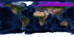
About 80% of the total landmass of the Earth is mapped by the STRM data, covering all land between 56 degrees south and 60 degrees northern latitude. A view of the data coverage is shown in the figure below.
External Links
- Original data is available from the Viewfinder Panoramas web-page created by Jonathan de Ferranti's http://www.viewfinderpanoramas.com.
Acknowledgement
Jonathan de Ferranti is thanked for making allowing us to make the digital elevation data available from within WindPRO.

